As you can imagine, this was not an easy project to undertake, was hugely political, came at a great expense, and was fraught with many delays. Ultimately, the arrival of the automobile, the push for the "beautification" of Ottawa, and the optimism of the roaring twenties led to this incredible project which transformed the west end.
I recently discovered a series of incredible, newly-shared photos on the Library and Archives Canada website (which is a rarity to find new content of any kind) showing the Champlain Bridge under construction. But not just aerial photos or boring bridge photos, but actually showing the men and machinery at work. It's an amazing glimpse into early 20th century engineering works, and helps bring to life the difficulties of building a bridge of that magnitude through the middle of the Ottawa River. I'm excited to share these photos today.
I've also mixed in other photos I've found over the years showing the Bridge in various stages of completion. It took a long time for Island Park Drive and the Bridge to be built, all in small phases. I've done my best to create a bit of a timeline as well, to chronicle the development. In all honesty, a book could be written about the challenges that came about at each phase. No decisions were easy (where the driveway was to be located? Through which farms and properties would it go? To which islands would it go? Would it link to Quebec? Who would pay for it?). And on and on it went.
* * *
Here is a timeline on the history of the Bridge, along with applicable photos over time:
July 1896: Robert H. Cowley acquires all of the land north of the CP Railway tracks (now Scott Street/Transitway) between Patricia and Carleton Avenue, right to the water (Nepean Township Lot 33, Concession A).
March 1899: Cowley hires John Bower Lewis, Ontario Land Surveyor, to take a survey of the three islands in the Ottawa River.
April 1900: Cowley purchases the adjoining land to the west (the east half of Nepean Township lot 32), expanding his holdings to approximately present day Remic Avenue.
September 1902: Cowley wrote to the Ontario Commissioner of Crown Lands to confirm his prioritized claim to the three islands off the shore of his lot 32 property. He also wrote to the Ottawa Improvement Commission (OIC) offering to waive his claim, and encouraging the OIC to acquire the islands, and build a connecting driveway through his (Cowley's) land. Word had obviously begun to spread in Ottawa about the OIC's interest in extending their Driveway (which at the time ended at the Experimental Farm) to the northwest. This was obviously a savvy move by Cowley, as the OIC driveway running through his property would drastically increase its value.
August 1903: Cowley lays out the subdivision plan for the Champlain Park neighbourhood (originally known as Riverside Park). The subdivision likely would have occurred soon anyways, but was likely fast-tracked to further appeal to the OIC as a popular summer resort location in the west end (which it soon became). You can read more about Cowley and the early days of Champlain Park in an article I wrote last year at https://kitchissippi.com/2021/10/12/robert-h-cowleys-vision-and-the-birth-of-champlain-park/
Early 1907: The OIC acquires the three islands from the government of Ontario.
July 1907: Commissioners of the Ottawa Improvement Commission visited the area and held a small ceremony to announce that the islands had been given names (after members of the Commission themselves!) and that these islands would be the terminus of the proposed new western driveway.
 |
| Ottawa Journal - July 6, 1907 |
1907-1920: Nothing happens. No official project is announced, no work is done. Cowley, believing that the driveway is coming soon, begins using the coming driveway in promotion for Riverside Park lots, but anyone buying a lot in anticipation would require a lot of patience. Eventually the OIC discovers that the area flooded heavily each year, and that portions of the planned roadway would spend the spring months under as much as 15 feet of water. By 1911 the driveway plan was considered a "mistake" and cancelled. Once WWI hits, any hope of revisiting the concept stalls completely. Some of Cowley's lot buyers/investors were not happy.
December 24, 1920: On Christmas Eve, it is front page news in Ottawa that as part of their spending plan for 1921, the OIC will build the driveway extension to Riverside Park. Though since all the land required for the project had not been acquired yet, they could not announce the official route yet.
 |
| Aerial photo from 1920 showing the three islands and a bit of Champlain Park at bottom left. You can also see the accumulation of stray logs along the shore. |
July 11, 1921: Work finally begins on construction of the West End Driveway! Phase one includes just the area from Richmond Road to the water's edge (Cowley's property), with some work to occur on Bate Island.

1922: The stretch to the River from Richmond Road was completed sometime in 1922. These photos below are from LAC and are undated, but are likely from 1922 or 1923. You can see the Driveway suddenly and quietly ends at the River, where you could drive your Model T right up to the water!
 |
| Ottawa River looking north to the islands and Gatineau in the distance (LAC, PA-034414) |
 |
| (LAC, PA-034415) |
 |
| Abutment where Island Park Drive ended at the water (LAC, PA-034416) |
 |
| This is a view down Island Park Drive which also shows its footpath and bridle path. Photographer is standing just a little south of where Sunnymede intersects today. (LAC, PA-034413) |
 |
| 1922 oblique aerial view looking north showing the new West End Driveway cutting through the wilderness. Other than the cottages near Westboro Beach and in Champlain Park, north of Scott at this time is largely just trees and bush. |
Late fall 1922: The West End Driveway segment from Richmond Road to the Grand Trunk Railway tracks (where the Queensway runs today) was completed. Efforts to extend south of the GTR in 1922 was delayed due to political reasons (at one point, 100 workers were laid off over an argument between the OIC and city council over the $1,400 cost of a new survey that was required for the area around Ruskin Street).
Spring-Summer 1923: The Driveway segment from the GTR to Carling Avenue was completed. Meanwhile debate raged about whether a link to Quebec should be made by connecting the bridge from Bate Island or constructing a bridge from Lemieux Island. City Council was pushing Lemieux Island, which made a lot more sense (it was 600 feet from Lemieux to the Quebec side, versus 2,000 from Bate Island), Lemieux Island was seen as a larger and more picturesque potential park space (at 17 acres, versus 11 acres combined for the three small islands), and it was to alleviate congestion at the Chaudiere far more than would a bridge at Bate Island. Ultimately, the OIC was committed to their plan to go to Bate Island, and wasn't worrying in the short term about the Quebec connection.
September 1924: Work finally began on the Champlain Bridge.
 |
| Ottawa Citizen - September 12, 1924 |
October 14, 1923: The full length of the new West End Drive (aka Island Park Drive) opened for traffic for the first time. There was no ceremony, simply early that Sunday morning, the barricades were removed by the OIC at Carling Avenue, allowing vehicles to travel the entire length from Carling to the River.
Fall 1924: By year end, all of the piers and abutments were in place for the first segment of the bridge to the first island, and it was ready to go for the installation of the iron portion in the spring.
In total there would be 420 feet to the first island (Riopelle). Then 70 feet to the next island (Cunningham), and finally 320 feet to the third (Bate). The bridges were to be built to handle a load of 20 tons, 24 feet wide, with a 5-foot sidewalk on either side. Five piers and six spans in the first bridge, four piers and five spans in the other. Making construction easier was the hard, rocky bottom and shallow water from the shore to the first island.
December 24, 1924: The contract for the iron work of the Champlain Bridge was awarded to Dominion Bridge Company. Their bid was the lowest in the tenders process, and they were to start in the spring of 1925.
 |
| Dominion Bridge Company ad, 1919 |
Spring 1925: The first bridge segments are in place! And thanks to some photos taken by Pittaway Photos of Ottawa, the moment is captured in time:
 |
| (LAC: e999908998-u) |
 |
| (LAC: e999908999-u) |
 |
| (LAC: e999909000-u) |
 |
| Aerial photo showing the bridge in place to the Island. August 12, 1925 |
Spring 1926: The flooring for the third bridge (from Cunningham Island to Bate Island) was completed, officially bringing the route to Bate Island to a finish. However, the roadway would not be opened for either pedestrian or vehicular traffic for another year.
May 1927: The Federal District Commission (the new name for the OIC, before it would later become NCC) made an announcement that the islands would be finally soon be opened up, and that all three would be transformed into small natural parks. Cunningham and Riopelle Islands were to be reserved for pedestrians, accessible by a staircase down from the bridge, while Bate would be encircled by a driveway for cars, so that they could park and enjoy the views from all angles. The opening of the bridges was delayed until the islands were ready for the public.
June 20, 1927: Thomas Ahearn, chairman of the FDC, announced that within thirty days, a start would be made on the construction of the "Islands Park" bridge from Bate Island to the Quebec shore, and opened by fall 1928. The start was delayed due to high water, with the concrete work beginning first.
September 13, 1927: At noon on a warm Tuesday in September, Governor-General Lord Willingdon cut the ribbon for the opening of the bridge to the islands at a ceremony attended by 200 people. The G-G was the first car to cross the bridge. The final price tag on the bridge to Bate Island was approximately $180,000 including the approaches, viaducts and clearing on the island.
 |
| Ottawa Journal - September 13, 1927 |
 |
| Lady and Lord Willingdon (Governor-General from 1926-1931) pictured in 1927, though not at the opening of the Champlain Bridge |
 |
| Ottawa Citizen - August 29, 1927 |
October 7, 1927: The Montreal firm of Quinlan, Robertson and Janin was awarded the $147,000 contract for construction of the sub-structure and flooring for the Bate Island-to-Quebec segment of the Champlain Bridge. The FDC supplied all the stone required (purchased locally) and the cement was supplied by the Canada Cement Company. There was some contentiousness around the selection of the Montreal firm, when most of the eight bidders for the contract were from Ottawa.
October 14, 1927: Construction began right away on the new segment. Careful planning was required, as the construction of a 1,900 foot bridge in rapid-running water was no easy task. All work was done starting on the Quebec side, nothing was brought in from the Ontario or Bate Island side. Before any work could be started, a 25-foot wide trestle bridge had to be built in order to accommodate the equipment needed in construction, including a gasoline-powered locomotive. It was constructed using 10x10 timbers, that would hold the 56 pound rails laid over it. A few photos from LAC capture the earliest days of construction, which ran right through the chilly winter of 1927-28. (I've done my best to try to put them in a chronological order):
 |
| Preliminary work in the water. A floating barge can be seen in the background, with Bate Island in the distance. (LAC - e999909060-u) |
 |
| Group of workers holding their tools in the water, with the barge still in behind. (LAC - e999909061-u) |
 |
| Construction site and shanties on the river's edge. (LAC - e999909062-u) |
 |
| Trestle bridge under construction. (LAC - e999909063-u) |
 |
| Machinery used in early construction. (LAC e999909048-u) |
 |
| Wood shanties and materials for construction (LAC - e999909059-u) |
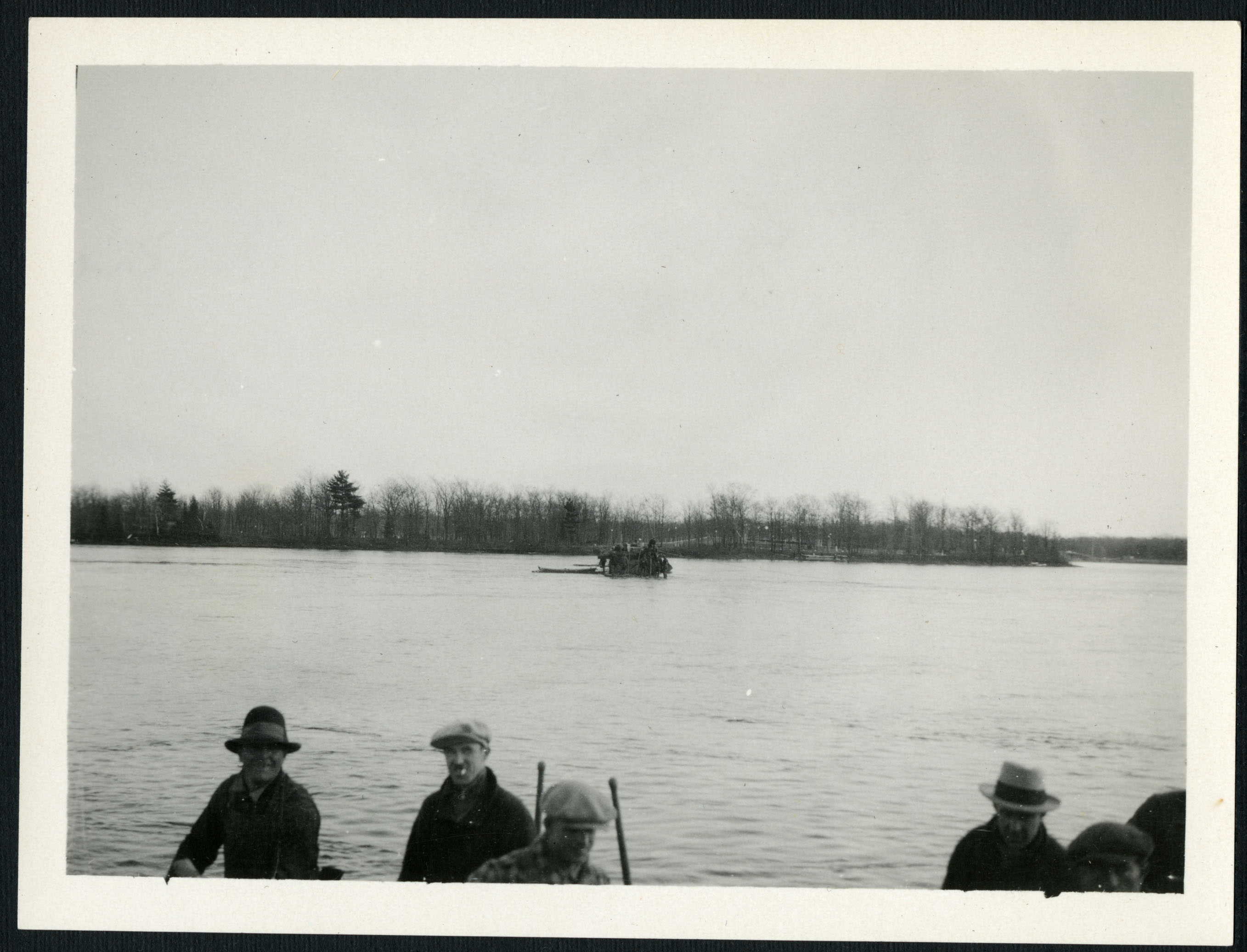
 |
| Logs beind hauled from river during construction. (LAC - e999909049-u) |
 |
| Logs being hauled from the River (LAC - e999909046-u) |
 |
| Worker in diver suit doing underwater work. (LAC - e999909050-u) |
 |
| Underwater work (LAC - e99909056-u) |
 |
| Trestle work on the shore (LAC - e999909051-u) |
 |
| Trestle bridge (LAC - e999909058-u) |
Winter 1927-1928: Work continued on the bridge throughout the winter, as the FDC wanted the bridge opened by the fall of 1928.
 |
| Icicles form on the beams of the trestle during the cold winter (LAC - e999909052-u) |
 |
| Work during winter (LAC - e999909053-u) |
 |
| Machinery at the Bridge worksite (LAC - e999909054-u) |
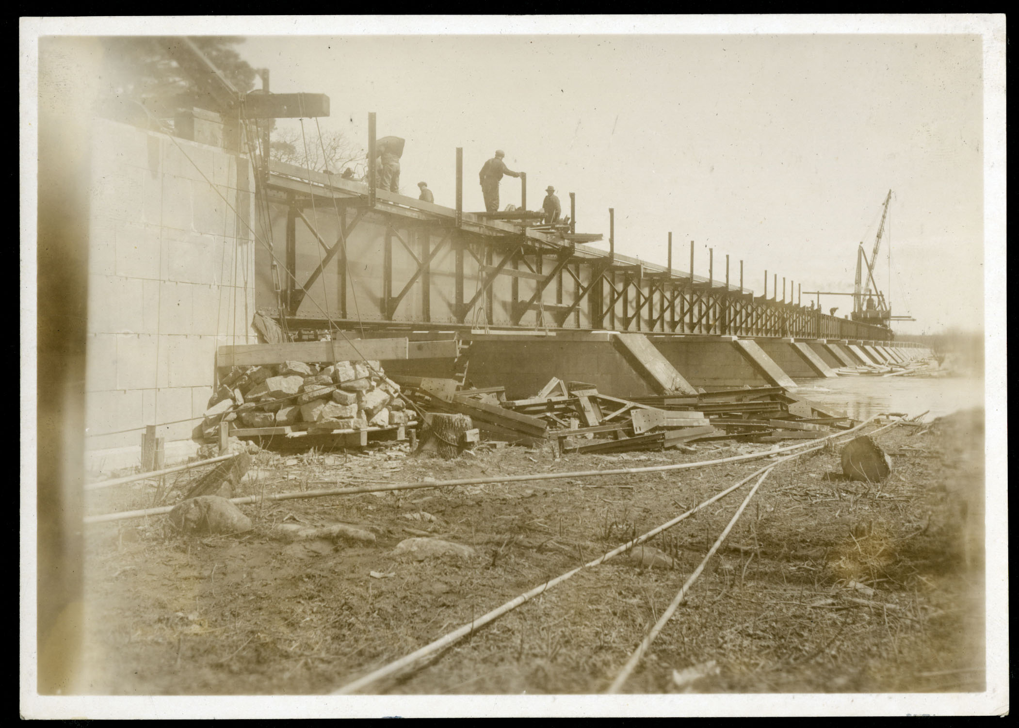
Late Spring 1928: the Substructure was in place by May.
 |
| (LAC - e999909047-u) |
 |
| (LAC - e999909055-u) |
 |
| (LAC - e999909057-u) |
 |
| (LAC - e999909064-u) |
 |
| (LAC e-999909065-u) |
 |
| Crane moving girders off side-angle (LAC - e999909002-u) |
 |
| (LAC - e999909005-u) |
 |
| (LAC - e999909007-u) |
 |
| (LAC - e999909008-u) |
 |
| (LAC - e999909003-u) |
 |
| Tracks used during construction (LAC - e999909004-u) |
 |
| The bridge nearing completion (LAC - e999909006-u) |
 |
| (LAC - e999909001-u) |
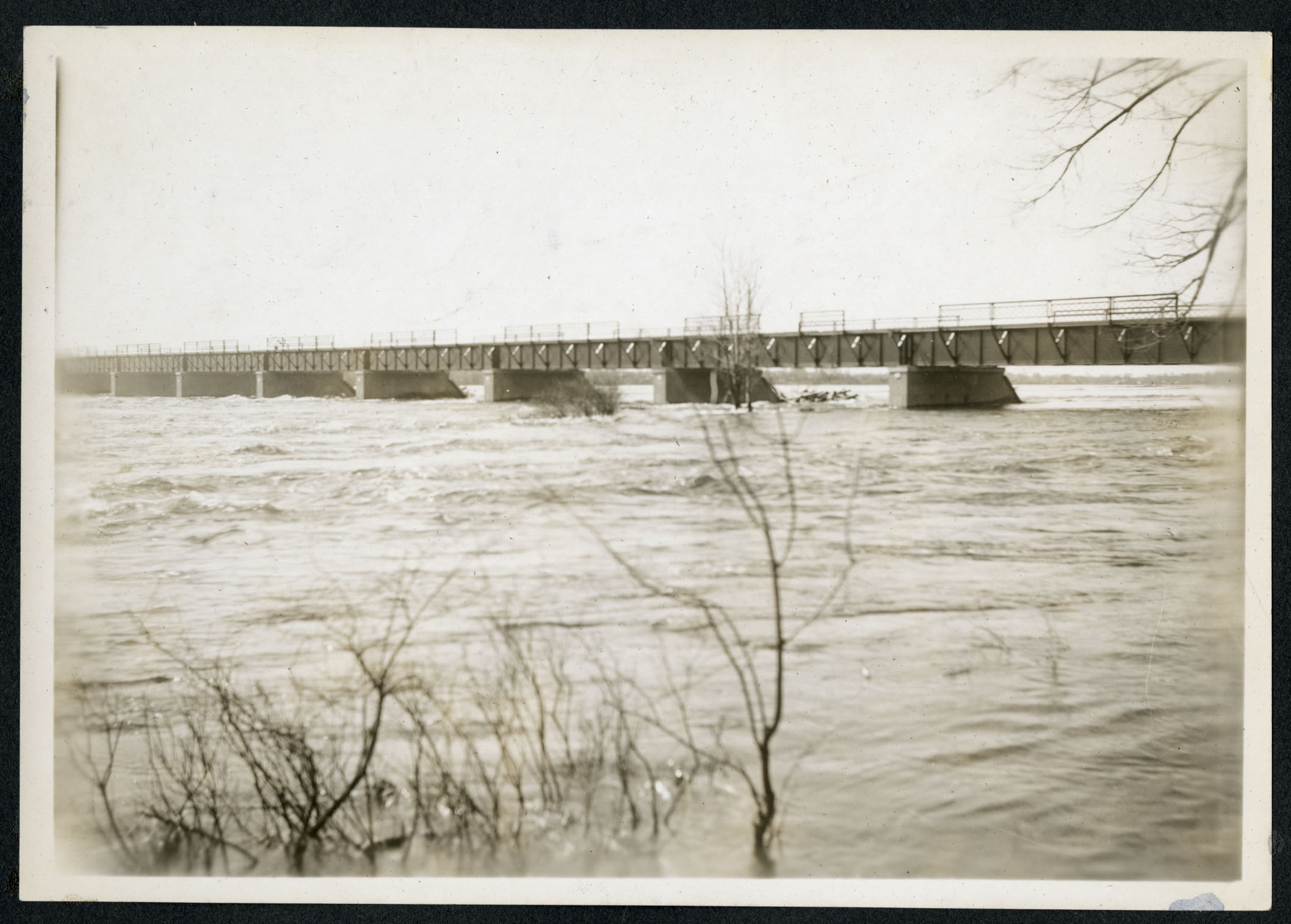
Spring 1928: Just as was warned to the FDC years prior, the area close to the Ottawa River was prone to flooding in the spring, and 1928 was a record-setting year for flooding. While construction work was held up on the north end of the bridge, the south end of the bridge found itself submerged under high water for much of the spring! The RCAF sent a plane overtop to capture the flooding from Woodroffe all the way to Champlain Park, and the photos capture the Champlain Bridge in mid-construction, but also significant submersion:
 |
| Spring 1928 view from overtop Westboro Beach |
 |
| View looking northeast, with the approach to the Champlain Bridge underwater in 1928. |
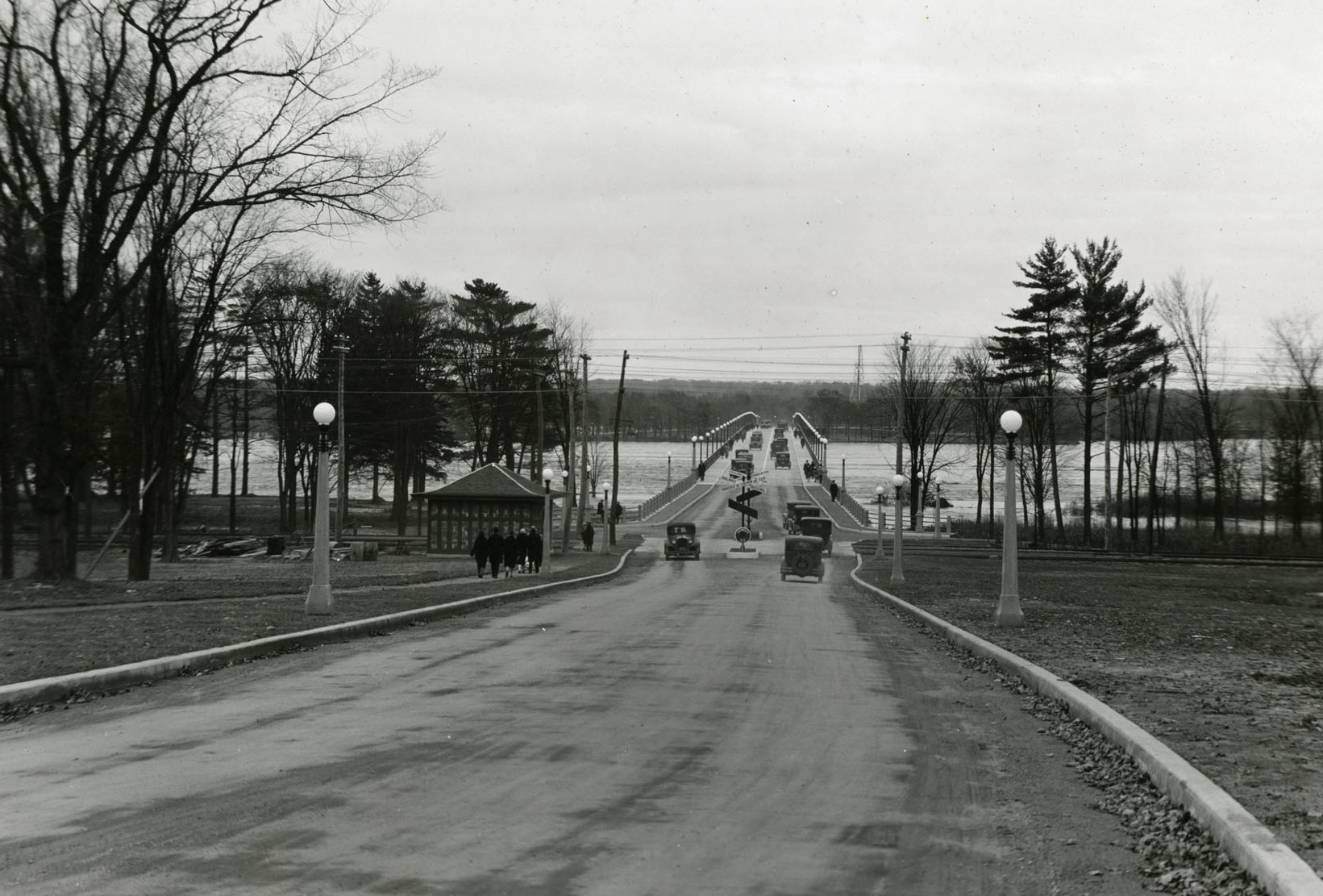
 |
| View looking south towards Island Park Drive and Champlain Park. The approach and much of Island Park Drive are under water. 1928. |
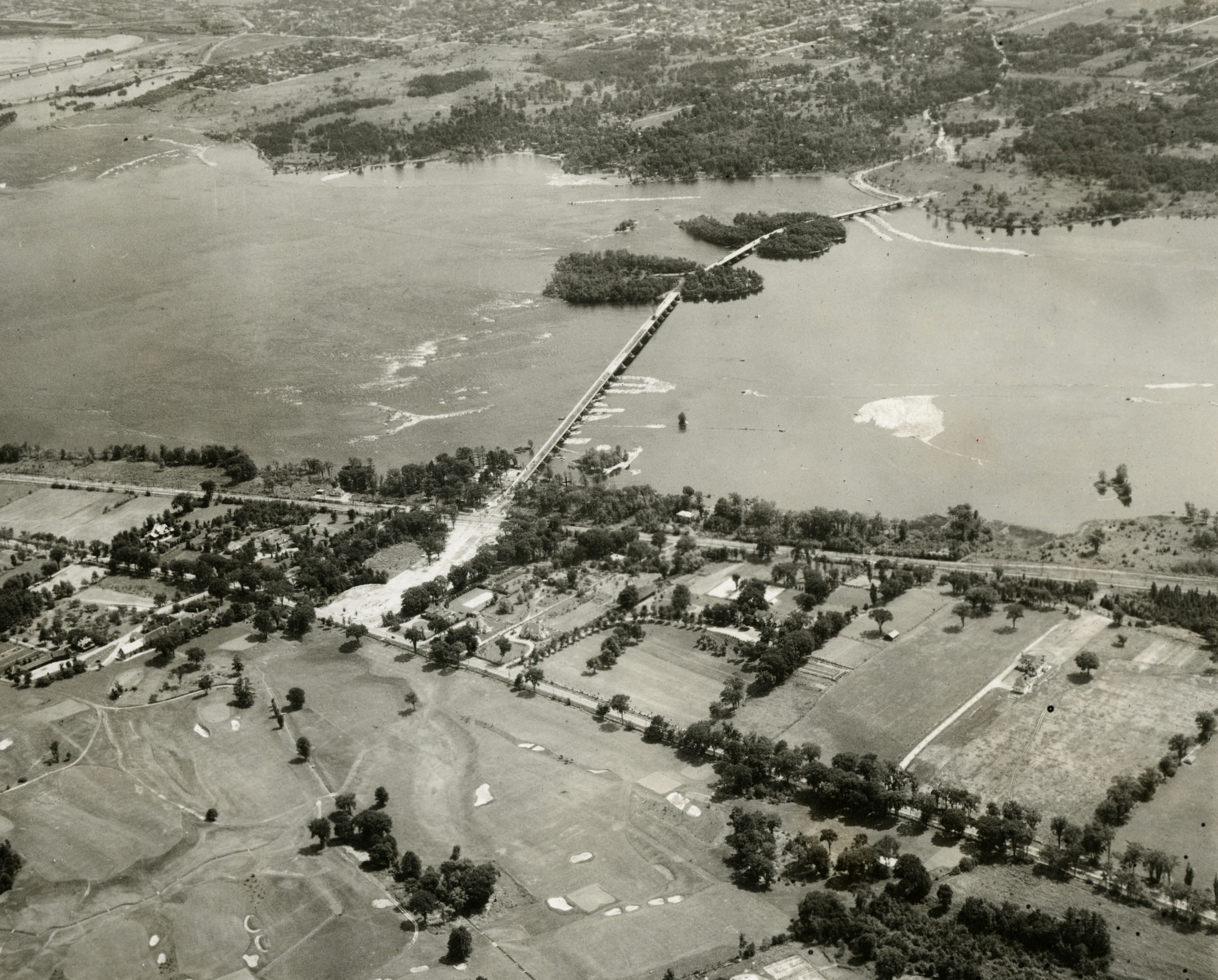
 |
| Overhead view of Bate Island looking west. The piers for the new north section are in the water. 1928. |
 |
| One last view looking southwest, again overtop of Bate Island. Spring 1928. |
Some of the damage done from ground level:
 |
| Looking south from the bridge that was washed out (LAC - e999909024-u) |
 |
| Island Park Drive under water (LAC - e999909027-u) |
 |
| Everything in the area under water. The bridge and Island Park Drive are in the background. (LAC - e999909028-u) |
May 1928: It was only in May of 1928 that the name Champlain was given to the bridge, and it happened without any fanfare that I can find in any of the local newspapers! It appears the decision was made and the name adopted, but without any coverage. It was selected by the FDC because of the local significance of Champlain stopping in the area of the Remic Rapids to take notes and elevations. FDC Chair Thomas Ahearn later stated in a request to have a plaque added to commemorate Champlain that "the very best monument to the great discoverer is the bridge itself".
July 6, 1928: The last span on the Bridge was completed.
July-August 1928: Because of the annual flooding, and what was considered a dangerous hard turn from the approach to the bridge, the FDC decided to build a new straightaway entrance to the bridge, which is the route that exists today (where Island Park Drive essentially becomes the Bridge in a relatively straight line). The original approach actually was kept by the FDC/NCC and became a parking lot just beside the bridge, though it was covered over a couple of years ago and is now just grassy parkspace.
October 22, 1928: In a grand ceremony held at 3:30 p.m., the Governor-General Lord Willingdon was once again called to cut the ribbon and open the full Bridge to vehicles. He cut the ribbon in the centre of the bridge on the exact boundary line between Ontario and Quebec. At the conclusion of the ceremony, more than 600 cars and hundreds of pedestrians crossed the bridge. Local media reported there were photographers and "motion picture men" on hand to record the event. I wonder where that footage ended up?
 |
| Part of front page story Ottawa Journal - October 23, 1928 |
On its opening, the engineers were commended for their work in building the entire span from Bate Island to Quebec in less than a year. The opening of the Champlain Bridge was considered a major triumph for the FDC as well, and its chairman Thomas Ahearn.
Here are some photos from after completion:
 |
| The original approach to the bridge from the Ottawa side, where it came in at almost a 90-degree angle. (LAC - e999909033-u) |
 |
| Looking north from the west side of Bate Island (LAC - e999909035-u) |
 |
| Looking south towards Bate Island and beyond (LAC - e999909034-u) |
 |
| Looking north from the Bate Island turnoff. (LAC - e999909036-u) |
 |
| Looking south from the north approach on Quebec side (LAC - e999909037-u) |
 |
| Entrance to bridge from Quebec (LAC - e999909038-u) |
 |
| Entrance to bridge on Quebec side (LAC - e999909067-u) |
 |
| Welcome to Quebec road signs at bridge exit. (LAC - e999909039-u) |
 |
| Aerial view from above Quebec side (LAC - e999909040-u) |
 |
| Aerial view from above Champlain Park, which shows both the old and new approach (LAC - e999909042-u) |
 |
| Aerial view above the islands looking north to Quebec side. (LAC - e999909043-u) |
I hope you enjoyed this photographic journey through the construction of the Champlain Bridge!
Super informative dedication to our history.
ReplyDeleteExcellent article, and the newly-found photos, especially of the flooding, are amazing.
ReplyDeleteI am going to share this with my gr 7/8s for some local history. Thanks!
ReplyDeletePhoto 50 appears to show the log booms just west of the bridge.
ReplyDeleteThis is so interesting! My great grandfather was in charge of the lights on the bridge.
ReplyDeleteThank you I just love this Ottawa history.
ReplyDeleteThat was an amazing read - thank you so much for sharing!
ReplyDeleteThank you for posting this information. It's very interesting. I'm amazed to see how quickly the Bate island to Quebec span was built while enduring a major spring flood.
ReplyDelete