Tuesday, December 12, 2023

A 1940s Christmas at Byron House

For the December issue of the Kitchissippi Times, I've written about a local history story that has unfortunately become lost to time. 

One of the most impressive homes on Island Park Drive played an important role during WWII! Read all about "Byron House" at https://kitchissippi.com/2023/11/30/early-days-a-1940s-christmas-at-byron-house/

Byron House/Kirkpatrick House in 1940

Bonus content! Incredibly, a telephone call from July 1941 made by two of the children at Byron House on Island Park Drive back home ot the UK was recorded and preserved by the BBC. You can hear a snippet of this call from Polly and Geoffrey Carton at: https://www.bbc.co.uk/teach/school-radio/history-ks2-world-war-2-clips-children-evacuated-abroad/zby4bdm

I've also amazingly tracked down video footage of the children at Byron House in an archive in the UK. I'm working with an archivist there to hopefully acquire this film footage (I have no idea how long it is, or what it shows), but I think it would be amazing to see some video of the house and the children enjoying it 80 years ago. Fingers crossed I'm able to get ahold of it soon.

The Byron House children out front of 539 Island Park Drive


The Byron House children work on a miniature model
of Island Park Drive as part of a school project in 1940


Sunday, December 3, 2023

Kitchissippi's Heritage over the last 20 years & the urgency of what's coming next

My November article for the Kitchissippi Times is an important one. I usually cover a single topic or event for the Times, but this month, as it was the 20th Anniversary issue for the Times, I chose to write about how heritage has evolved in our neighbourhoods over the last twenty years. But more importantly, how heritage is severely threatened by Ontario Bill 23, which in a year's time will effectively render almost all of our most heritage-worthy (but not-yet-designated) buildings exempt from designation. 

This is an issue which is getting hardly any attention in mainstream media. Maybe because there's still another year to go until it becomes a real problem. But that year will go quickly, and by then, or even six months from now, it will be too late. 

Please read the article to learn more about what we stand to lose not only in Kitchissippi, but across Ottawa and the province as a whole. 

https://kitchissippi.com/2023/11/04/protecting-the-past-how-kitchissippis-heritage-has-changed-over-20-years/

The only solutions are to cross fingers and close our eyes and hope the provincial government changes its mind about the heritage registers (not likely, maybe not even possible now); to ignore it and just let it happen and see so many heritage designation-worthy buildings be torn down and there will be nothing we can do about it; or we can act now and pursue designation of those buildings we deem most important to maintain. 

As part of the article, the Times filmed me giving a little 15 minute guided tour of Kitchissippi's most heritage-worthy buildings, with a few quick facts and details about a few of them. You'll find the video at the bottom of the article, or you can view it directly on Youtube at:

https://www.youtube.com/watch?v=WhYUjRwJkRk

I know the City and our councillor Jeff Leiper, as well as each community association in Kitchissippi, are taking steps to review what might be possible, and to prioritize which buildings ought to be reviewed for designation. I wrote up a detailed report myself for Jeff's office, and included a "top 25" list for his consideration, and I'll be speaking with all the community associations next week about it, and offering my help. But it will take a lot of community input to help push this along. It's a mad scramble, and it's a mess, but this is what we're stuck with.

If you'd like to provide your input, the City is asking for it! Check out this link for how you can contribute: https://engage.ottawa.ca/reviewing-heritage-register

More to come!


How garbage helped build the parkway and saved Mechanicsville

This fall, I wrote a two-part column for the Kitchissippi Times on how garbage was used to fill in three bays on the Ottawa River, between Mechanicsville and LeBreton Flats, creating artificial land. That land was primarily used for the creation of the Kichi Zībī Mīkan (Ottawa River Parkway), but much of it still remains unused, awaiting potential future use by the NCC for embassies or who knows what at LeBreton. 

Part one I previously posted here in the Museum (https://kitchissippi.com/2023/09/11/early-days-from-landfill-to-useable-land-how-the-ottawa-river-shoreline-was-built-using-garbage/).

This is part two: https://kitchissippi.com/2023/10/25/early-days-how-garbage-helped-build-the-parkway-and-saved-mechanicsville/

Part two focuses on Lazy Bay, and how this popular water spot was filled in, which may have actually saved Mechanicsville. If it wasn't for filling in the Bay, the Parkway may have had to run much further south, which would have cut significantly into the housing of the neighbourhood. And honestly, that wouldn't have been seen as that bad an option to City Council, who considered the whole of Mechanicsville for major urban renewal at the time. A huge 1960s project would have seen the entirety of the neighbourhood torn down a la LeBreton, and replaced by apartment blocks. Thankfully this was avoided, in part due to the filling of Lazy Bay. 

The building of the National Arts Centre also played a key role in filling in these bays, and you'll want to read about the astonishing fact that less than a year after garbage was dumped indiscriminately in to the bays, expensive contracts were let to remove some of the garbage! (But only in certain areas, certainly not the full length of the Ottawa River). 

I plan on writing a "part 3" over the Christmas break (exclusively here for the Museum) on what all this means today, and what water and soil testing and sampling has shown over the last 20-30 years. The results are interesting, and I put in quite a bit of time in the fall digging in to the results. So more to come on that soon. 

Note, I will also be making a presentation about this whole topic, which will feature many visuals/photos/etc. for the Historical Society of Ottawa on Saturday January 27th. It will be at 1 p.m. but will NOT be broadcast online I don't think. It will be an in-person Speaker Series event at the auditorium of the Ottawa Public Library. I don't believe you need to be a member of the HSO to attend, but I certainly encourage you to consider taking out a membership to help this valuable group, and the work they do to help promote and preserve heritage in Ottawa. 

https://www.historicalsocietyottawa.ca/activities/events/eventdetail/113/16,17/ottawa-s-shoreline-built-from-garbage

Please enjoy part two and perhaps I'll see you in January!

Lazy Bay-Bayview Bay-Nepean Bay in 1928

The same three bays in 2022

Thursday, September 14, 2023

Creating land: How the City's garbage became the new Ottawa River shoreline

lookng east from Bayview, November 1962
(source: City of Ottawa Archives, CA-8684)

While conducting research for my book on Mechanicsville, I began looking at the history of Lazy Bay, and the "Lazy Bay Commons", as a portion of the abutting land is sometimes called. For those of you who don't know the term, Lazy Bay is the little bay that comes in from the River alongside the Parkway, just north of Laroche Park. Lazy Bay Commons is the greenspace south of the Parkway, on which the NCC is proposing the construction of a row of embassies. 

Prior to doing this research, I'd known that when the Parkway was first built, that the City and NCC had built up areas along the shoreline to help ensure a relatively straight line of travel, close to the river, to take advantage of the picturesque views. In order to do this, a large area in the LeBreton Flats, Bayview and Mechanicsville areas (as well as an area closer to McKellar and Woodroffe) were filled in. I also knew that rock was brought in to create the base.  And probably like most people, that's about all I really knew. Yes I'd heard the rumours of old garbage dumps or pits along the route, and probably like most people, assumed it was just old temporary dumps that had existed in LeBreton or the open areas around Bayview. 

However, as I dug deeper in to the research, I discovered that in fact, the story was far more complex. That the story of the Parkway and the created land over which it travels, from Mechanicsville east through LeBreton Flats, has many interconnecting parts to other major NCC and City of Ottawa projects happening at the time. Most notably - the shifting of all city garbage dumps and collection from the west and east ends - to the shoreline of the Ottawa River. Yes, in the early 1960s, the city garbage trucks brought their loads to the shore; ordinary citizens brought their old fridges and televisions and bags of trash; and many of the houses of LeBreton Flats, exprorpriated as part of the "urban renewal" of the neighbourhood, were discarded just a few hundred feet away into Nepean Bay. 

My September column in the Kitchissippi Times introduces this topic, and the history behind the Parkway and how the new land was created. This was not just an Ottawa concept, cities across North America were doing the same thing. And the short-sighted solution to solving problems at the time, are now wreaking havoc 60 years later as plans are made to build on these articifically-created landfill sites, including most notably at Lazy Bay Commons.

Ottawa Citizen - March 8, 1963

This article is part one of a two-part series (part two will run in October), and it really only scratches the surface of the whole story, but I think gives a good overview. Please read the full story at the link below:

https://kitchissippi.com/2023/09/11/early-days-from-landfill-to-useable-land-how-the-ottawa-river-shoreline-was-built-using-garbage/

Note that in the printed/paper version of the newspaper, an error was printed, giving the date of one of the photos as 1968. That is incorrect, it was from 1962. It is fixed in the online edition.

Also, the perils of writing for a print newspaper meant that I had to cut down a lot of content into about 1,600 words, which my editor further edited down to fit. One quote I really liked that got removed I'm going to re-add here, from near the end of the article, discussing the problems in LeBreton Flats as families left their expropriated houses, and they were left boarded up and vacant:

Though the first houses began to be demolished in October 1963, Ottawa’s Fire Chief urged it wasn’t happening fast enough, and pressured the NCC, calling the houses “time bombs ready to go off”. The Journal wrote of the boarded up homes: “They’ve been taken over by drunks who wine-and-dine and sleep at their leisure, children who play in the ghostly rooms and sheds, and scavenger junkmen at work, systematically stripping them of everything saleable.” 

The NCC quickly began pulling down the houses, and placing them in the Bay. Many of the original LeBreton Flats houses still exist today – buried deep below the Parkway.

I hope you enjoy the article. Remember to watch for part two in October! Also I will be giving a public talk on this subject in January for the Historical Society of Ottawa. Stay tuned for more info on that!


Monday, June 12, 2023

Goodbye 226 Carruthers Avenue - A profile

October 2020 - Google Streetview

My recent article on 50-52 Armstrong was quite popular, so I thought I might do another similar write-up on another classic Hintonburg house about to meet its end. 

The house at 226 Carruthers Avenue is a tiny little one-and-a-half storey house set well back from the street. This little place has seen it all in Hintonburg, from the neighbourhood's earliest beginnings. It was actually the first house built on Carruthers south of Scott Street (the Hintonburg half of Carruthers). It dates back so far, in fact, that it had a Cave Street address when it was first built in the 1880s (Carruthers Avenue's original name). It stands today in the middle of a full built-up neighbourhood, with houses all around it, but in 1888 when it was first constructed, it stood against the backdrop of a small forest that came right up to the backyard.

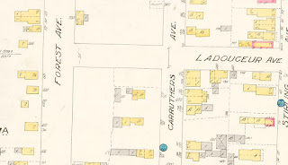
I don't have a photo of the 19th century Hintonburg forest, but this fire insurance plan demonstrates it pretty well, showing the west side of the street on the top, and no Hinchey Avenue or Pinehurst Avenue to be found. Instead, "thickly wooded ground (mostly pine)" make up the area in behind, with pine trees coming right up to the rear of the house.

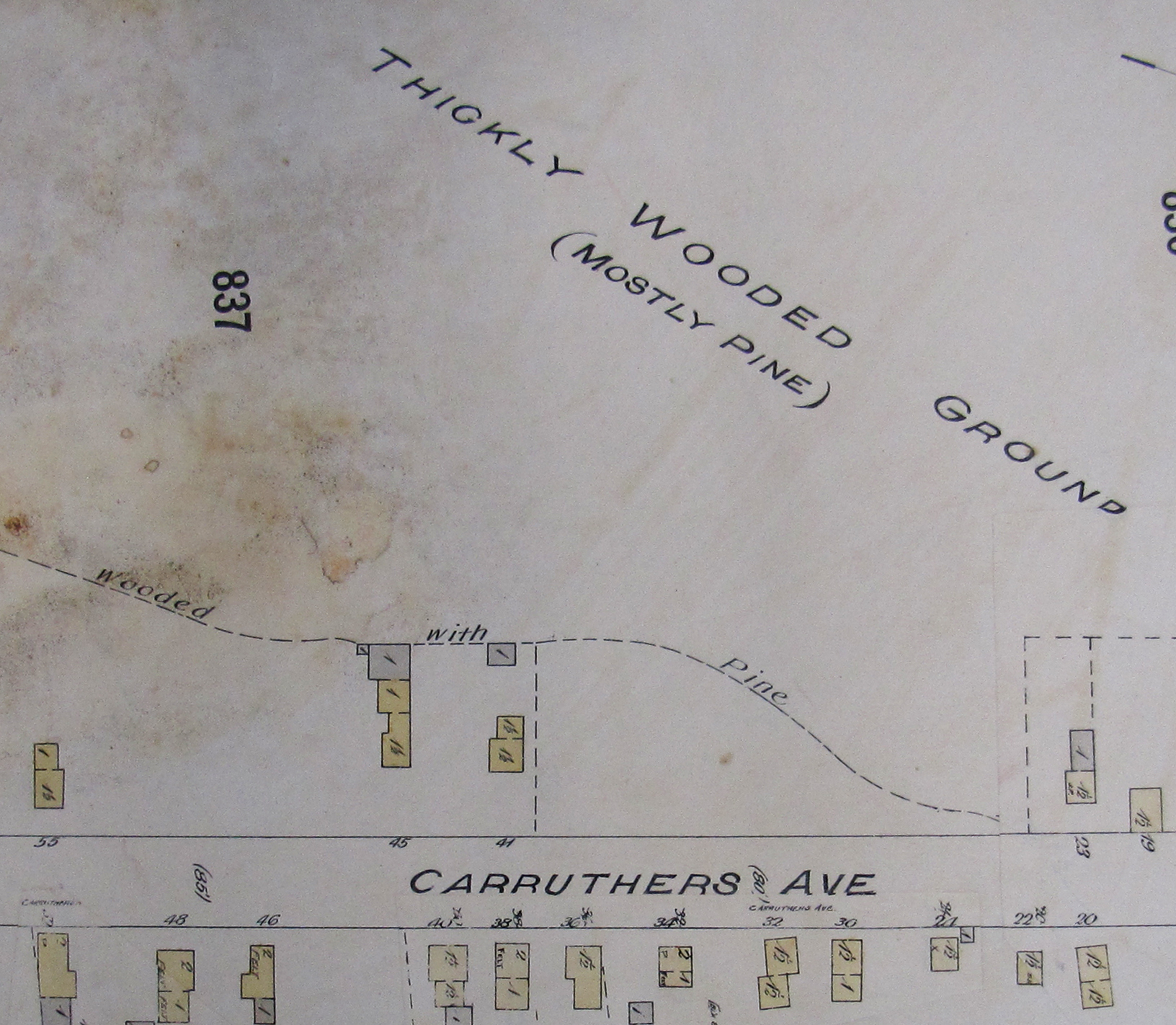
The 1902 fire insurance plan of Ottawa, showing
Carruthers Avenue. 226 Carruthers was then numbered
#41, and can be seen as one of the only houses on the west
side. The other streets to the west do not exist yet. Even
Ladouceur Street has not been cut through yet (houses in
its path on the east side of Carruthers would later be moved)

The house at 226 Carruthers is a hearty one. It has lasted 135 years, through at least three significant fires, the arrival of electricity, plumbing and sewers. It has stood as part of rural Nepean Township, the independent village of Hintonburg, and in the City of Ottawa. Much larger buildings have sprung up on either side, dwarfing the little house with its 27-foot deep front lawn. But it has persevered through it all.

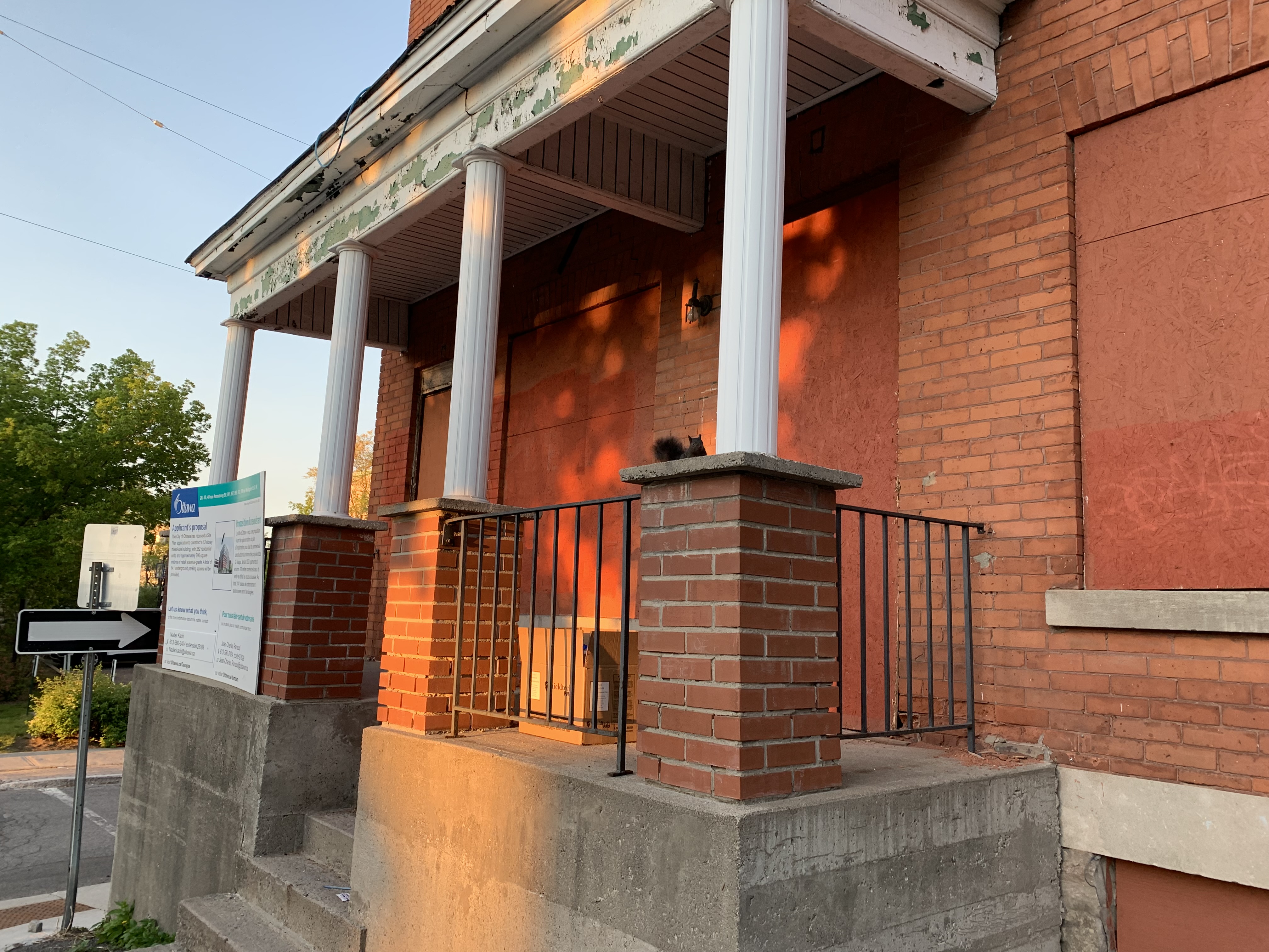
Go by today, however, and the fences are up. Demolition is imminent any day. The development plans are approved, and this small piece of property will flip things on the neighbours, suddenly dwarfing them as a big, three-storey strucutre. The little old home that hundreds of Hintonburgians have called home over the last century-and-a-third will be taken down in minutes.

226 Carruthers was constructed in 1888 by 39-year old British-born geologist Francis John Stubbington, husband of Mary Ann, and father of five (with two more yet to come). The family had arrived in Canada not long before 1888. They came right to Hintonburg, at first renting a small house on Stirling Avenue, where their fifth child, daughter Dulcibel Maria Stubbington was born in December 1887. 

Stubbington acquired lot 12 on Carruthers from lumberer Robert Hurdman, who had acquired most of Carruthers Avenue a few years prior. They had a handshake agreement on the deal. Stubbington's purchase was never officially registered, as often buyers would work out an arrangement that was akin to a "lease to own" type of agreement, where they would make payments on the land and build a house over time, with the understanding that once the land was paid off, the property would be deeded to them. Renege on the land payments, and it goes back to the original owner, including any structures that had been built thereupon. 

Stubbington would have started construction early in 1888, the small frame house likely not taking too long to build in its first, likely primitive state. 

The Stubbingtons settled into early Hintonburg life, with eldest child Mabel scoring as the top student in her class (senior third class) at Hintonburg Public School in June of 1889. Francis was listed in various sources as a geologist, engineer and machinist during his years in the village.

However, the family did not remain in Hintonburg long, as by early 1891, the family was living in the Sudbury vicinity, where they ultimately would remain, Francis no doubt called in for a mining job he couldn't refuse. Later he would be listed as a 'prospector' at Copper Cliff in records. 

The house went through a series of occupants, with its next real owner-occupant being Frederick Murch, who acquired the property from the estate of Robert Hurdman on December 29th, 1908, for the sale price of $1 (which indicates that likely Murch had been paying Hurdman gradually over years), which is confirmed by the fact that records show he had first moved into the house between 1902-1903. 

Murch was a mill labourer, and had actually first been living on Carruthers in a different house (262 Carruthers) dating back to about 1898. He was English-born, and had a wife Fanny, and two children.

By 1912, Ladouceur Street was cut through, and the appropriately-named Forest Avenue (now Hinchey) in behind was beginning to fill with houses.

1912 Fire Insurance Plan

The fire insurance plan above also shows the large rear shed that was built sometime around 1910, and still stands today (or at least an older shed with the same footprint still stands today).

***

In 1915, the double next door at 228-230 Carruthers (which is also fenced off and appears destined to be demolished sometime soon) was built. Its construction, however, appears to have been a disaster. That June, Spadina Avenue real estate agent Ernest W. Foster acquired the full lot (which included 226 Carruthers and the empty half lot to the south) from Louis A. and Minnie B. Smith, and took out a mortgage for $3,400 towards the construction of the duplex. Less than a month later, Foster signed a sale agreement with Morris Glattenburg, a St. Patrick Street grocer, to buy the full property. It is unclear if it the deal was made in anticipation of the completion of the house, or if Foster sold it mid-construction, but regardless, Glattenburg took over the project.

By October, Barrett Brothers, one of Ottawa's top lumber and contractor supply shops put a lien on the house, for lack of payment on a bill of $178.18 owing. Glattenburg took out an additional mortgage of $820, from Harold K. Pinhey, son of Charles H. Pinhey, and a local investor/capitalist. But by year's end, he gave up, and surrendered the property to Pinhey due to finances. Oddly, records show Pinhey sold the property back to Louis Smith a year later; the same Louis Smith who had owned the property prior to the double being built! 

228-230 remained a rental building for the duration of its life. You could even obtain free accommodations in 1916...if you were a lady:

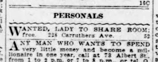
Ottawa Citizen, August 18, 1916

During WWII, it was renovated to accommodate two units in each half. A quick look at records from 1945 show families of 4 and 3 living at 230, and families of 8 and 3 living at 228. That's 18 people living in the house!

Records show that both buildings, 226 and 228-230 Carruthers have been rental properties for the last 100+ years, and interestingly, whenever the houses were sold, they were sold together, as the entirety of lot 12 on plan 83. The owners over time have been: Abbot Helmer and James H. Gowan (1917-1921), Thomas Heanin (1921-1941), Blanche Joanette (1941-1945), Rogers Joanisse (1945-1959), Jakub and Yvette Ostrowski (1959-1976), and Ainsley T.E. Anderson (1976-at least 1996, when the records I have free access to end). 

The property (again including both buildings) sold in 1941 for $3,300, in 1945 for $4,000, in 1959 for $12,000, and in 1976 for $65,000. 

***
 
Back to 226, Frederick Murch's wife died in 1914, and he moved out. A variety of tenants occupied the house over the next 20-plus years. The house shows up on the 1921 Census as the home of 24-year old Hintonburg-born "riverman" Joseph Lessard, his wife Marie Rose, and two young sons René and Leo. It also notes the house contained just three rooms (that's total rooms, not bedrooms), and that the Lessards were paying $10 per month in rent. Sadly, 3-year old René would pass away later that year from diphtheria. (Annoyingly, it appears the house was vacant or missed on the 1931 Census).

The house had its first fire late in the evening on May 9th, 1925. While Alfred O'Connor was not at home, and his wife and four children were in bed asleep. Mrs. O'Connor was awakened by smoke, and discovered that the kitchen was on fire, and spreading to the rest of the house. She managed to get all four of the kids out of bed and out of the house, and went over to the neighbours. Firemen were called, and the entire interior of the house and all contents destroyed. Alfred came home just before midnight to the scene.

The shell of the house must have been salvaged, as the house was rebuilt eventually (it was listed as being vacant in the summers of 1925, 1926 and 1927), but occupied again by 1928. 

On January 7, 1937, another fire happened in the house, when stovepipes overheated, which set fire to an upstairs partition while the house was occupied by a Mrs. D. McLeod. It was reported that damage to the house in this instance was "slight". 

Around 1937-1938, a new family moved into 226 Carruthers and would remain for well over a decade. At the time, Paul Parent was 28 years old, working as a machinist, with a wife Anita, and three young children.

On Monday February 12th, 1951, 226 Carruthers was the scene of yet another fire, but this was its most horrific and terrifying. Just before 5 p.m. that Monday afternoon, Paul and Anita's 14-year-old daughter Anita (who had the same name as her Mom) was attempting to light the wood stove in the kitchen of the house, likely to start making dinner for her family. The fire did not immediately start, so Anita grabbed a can of coal oil to help start the fire. Unfortunately, she made a mistake - she grabbed a can of gasoline that was stored in the kitchen, used in summertime for an outboard motor.  She poured the gasoline into the stove, and then lit a match. There was a massive explosion. "Spurting, searing flames enveloped her body as the stove exploded", wrote the Journal. She had been turned into a "human torch". 

The only other occupant of the home at the time was Anita's 15-year-old brother Donat Parent, who came rushing in from another room where he had been on a telephone call with a friend. Donat was "galvanized into action by shrieks of pain and terror", reported the Journal.

"At the kitchen door, he was met by a swatch of blow-torch like flames. Vainly he tried again and again to penetrate the room. It was no use", said the Journal. Donat ran outside and ran into next-door neighbour 11-year-old Ronald Lepage, who had no doubt heard the explosion. Donat sent Ronald to the corner of Hinchey and Ladouceur Street (the location of the nearest fire alarm box), to ring the alarm. Firemen from three stations were now on their way.

"Agonizing screams from his trapped sister made the youth determined that he would get into the kitchen", continued the Journal. "Then there was silence".

"Realizing that every second was precious if he was to save the girl, the youth raced around to the front of the home, and after smashing a kitchen window, pulled himself into the burning room. His sister was lying on the floor unconscious, her clothes afire", reported the Citizen. "Without thought of his own safety, Donat lowered himself into the burning room, and after smothering the flames consuming his sister's clothing, carried her out of the window and to the safety of a neighbour's home". 

Ottawa Citizen, February 13, 1951

Anita was taken next door to 224 Carruthers, the Lepage family home.  Upon arrival of the first firemen, she was transported immediately in an emergency car, and was in a fight for her life. She arrived at hospital with first, second and third degree burns on her face, arms, upper portion of her body and legs. Donat also had minor burns to his hands, arms and face, but was treated at the scene.

The teens' Mom was alerted at work a while later when police came to tell her about the fire, and the condition of her youngest daughter. 

The story was front page news the next morning, with a large photo of heroic Donat appearing at the top of that front page. The Citizen reported that Anita remained in very critical condition, and that her family was understandably very concerned. "I'm not worried for myself", Donat told the Citizen, "It's my sister's condition that worries me right now. I only hope everything will be all right." 

February 13, 1951
Front page of the Ottawa Citizen


Though I could find no other follow-ups in the media about the fire or Anita's condition, a bit of research shows that she did survive and eventually recovered. Donat Parent was a hero for his actions, as was Ronald Lepage, whose quick action in ringing the fire alarm saved 226 Carruthers. The interior suffered significant fire damage, but was repaired soon after, and the family moved back in, though it appears they did not remain long. 

Gerard and Madeleine (Richer) Rolland became longer-term tenants through the 1950s and 1960s, with three young daughters. There could have been longer-term rentals since the 1960s, but I didn't dig into this era of the house's history for this article.

Unfortunately I could not locate a vintage street-level photograph of 226 Carruthers (if anyone out there has one, I'd love to add it to this story!). I do have a couple of old low-elevation aerial photos that shows the house a little. In the top one from December 1965, the house is hidden behind the larger building at the corner (Carruthers is along the top, Hinchey at bottom), but the large shed can be seen.

December 1965 ,with large shed at rear
(Source: City of Ottawa Archives, CA-09085)

In this second photo, the house is again hidden, a victim of its major setback from the street. It's a nice shot of the store and building at 224, and the double at 228-230 at least.

April 1966
(Source: City of Ottawa Archives CA-09136)

Here are two shots taken a few weeks ago, showing both 226 Carruthers, and 228-230 fenced off, usually a sign that the bulldozers are on their way. To note though, from everything I've read, 228-230 was not intended to be demolished (yet at least), and is not a part of the redevelopment of the 226 part of the lot. So perhaps it will remain standing a bit longer. 

228-230 Carruthers Avenue - May 2023
(Photo by Dave Allston)

226 Carruthers Avenue - May 2023
(Photo by Dave Allston)

The property is now owned by an incorporated business known as 226 Carruthers Holdings Inc. Back in the fall of 2021, an application was made to the City to divide the property into two parcels, creating one parcel for the existing 228-230 part, and a new parcel for what would be built at 226. The application would also create an easement for a shared driveway. 

The new building at 226 Carruthers was to be a three-storey, three-unit dwelling.

Minor variances were sought at the City's Committee of Adjustment in October of 2021, and the application was refused (they wanted to make the new 226 lot a width of 8.4m when 10m is required; they wanted the lot area to be 225.6 m2 when a minimum of 300 m2 is required; and they wanted an interior side yard setback of just 0.2m when a minimum of 1.2m is required). The owners took the decision to the Ontario Land Tribunal, where in July of 2022, the appeal was approved, and the project could go ahead. 

Proposed three-storey, three-unit building
(Source: Fotenn Planning + Design, Twitter)


So farewell to 226 Carruthers Avenue, a small but integral piece of Hintonburg's history that will sadly be lost like so many before it. 

Friday, June 2, 2023

The 1931 Census of Canada! An Index for Kitchissippi

Ottawa Citizen, May 28, 1931

Yesterday, June 1st, 2023 marked a major milestone date for Canadian historians and genealogists! 

Library and Archives Canada after 92 years were finally legally allowed to release the Census pages as of yesterday, so they've been uploaded to the link below. However, for now, it is only raw page scans. Nothing is keyword searchable yet. That will take time, and will be accomplished through LAC partnerships with Ancestry and FamilySearch for indexing and searching. (When the 1921 release occurred, it took about three months for name and keyword searching to be released). 

Here is where you can go search: https://recherche-collection-search.bac-lac.gc.ca/eng/census2/index1931

And here is a link to some background info about the Census release: https://library-archives.canada.ca/eng/corporate/website-updates/pages/census-1931.aspx

In a few months time, we'll be able to just pop a name into a search engine and find the person in seconds. However, if you're like me, you probably just can't wait that long, and you want to look up a grandparent or other relative now! Or maybe you want to see the info on who was living in your house, since by 1931 many Kitchissippi houses were already built (this will be the first Census that many Wellington Village houses will appear for the first time, for instance!). Personally, this is an exciting day as it is the first Census my maternal grandparents will appear in, having been born in 1927 and 1930. 

I'm providing some helpful info so that you too can navigate through the files and hopefully find your ancestor quickly. Some of the info I'm sharing below will help you search generally, but I'm mainly including info that will help someone locate a person who lived in Ottawa and especially Kitchissippi.

The search function as of right now is basic, and pretty frustrating if you don't know what you're looking for. You need to enter a Province, District and Sub-district. Sounds easy enough, but it isn't. The sub-districts are just listed with vague township or ward names, and sometimes as many as a dozen or more with the same name. And there is no map or code that can help decipher.  

(If you've been reading some online websites and message boards, you may have heard recommended a website called ScholarsPortal that has a map tool that will tell you the 1931 Census district and sub-district if you enter an address. Don't use that tool, it's not accurate at all.)

It seems that for the 1931 Census, they simply used the electoral district boundaries, from the 1924 redistribution. This means that all of Kitchissippi is contained in Carleton County (which was divided basically where today's Somerset and Kitchissippi wards are split), which is also the Census district Carleton. Everything west of today's O-train line is Carleton district, everything east of it is Ottawa district.

(Source: LAC, G1116.F7 .C3 1924)

How to search for a Kitchissippi address:

So when you go to the Census page, select Province "Ontario", District "Carleton", and then for Sub-District, I've made an index in Excel listing every Census page for Kitchissippi, and which streets appear on each page. Many streets appear on multiple pages, and even in multiple sub-districts (if it's a long street), so you may have to look in a few spots. Note too that many street names have changed, so I've also added in the street name conversions at right for reference. 

Click here: Kitchissippi 1931 Census Index

Note also that in my Index, I've listed the page # meaning the actual census page # (the number written on the original copy page). You may get confused by the LAC website page numbering, which adds a title page for each sub-district. So if my index says you want page 5, then you want LAC website "item" 6. 

Still not finding your person/house?...

In about half the cases on the Census, the full civic address is listed (a street name with a house number), but in many cases, it's just a street name. Or even just simply "Nepean". Those will require a little extra digging. 

If it can be of any help, I've uploaded the entirety of the street listings for Might's City of Ottawa Directory for 1931, which shows all residents of each street, sorted by house number. It's a rather poor quality scan which I did quickly some time back at the City Archives, not intending to ever publish it, but at this point, it could be a handy tool so I thought worth uploading to share. You can save this document to your PC.

Click here: 1931 City Directory listing by street

Unfortunately, it is not an OCR scan, so you cannot keyword search it. This document will only help you if you already know what street you're looking at, and want to figure out what the house number is that's missing from the Census, or you're trying to pinpoint the location of a house on a street.  Or this could be handy if you think you know which street your relative lived on, and you want to verify that first before digging through the Census pages. 

***

How to search for a City of Ottawa address:

If you're looking for someone within the City limits of Ottawa, you'll want to search in District "Ottawa", but I'm afraid I don't have time to create an index for that. You're on your own to hunt through the individual pages. Perhaps these images below might be of help... it's the descriptors for the ward boundaries in the City at the time. This could help you narrow down your search area:


***

How to search for an Ottawa address that was once rural:

If you're searching for people who were living in what is now within Ottawa, but was in 1931 a suburb or rural area, and the Census sub-districts you're looking at show a township lot/concession as their descriptor, the best quick tool I can suggest to find a lot/concession for the address you're looking up is to do the following:

i) Go to https://maps.ottawa.ca/geoottawa/

ii) Then at the top right, click on the icon that looks like 3 pieces of paper stacked (third icon from the left). It will open a new little menu beneath it.

iii) This is the "layers" menu. Click the fourth one in the submenu "Property parcels", first by checking the little box next to it, but then clicking the arrow to the left of the check box. When it expands, check the box next to "Township Lot Labels". This will add the old traditional lot/concession numbers to the map.

iv) Go to the search box at the top left of the page and enter the address you'd like to find. If you don't know the exact address but know a general street or intersection, enter that. It will center the page to your selection, and even add a red dot on the specific address if you've entered one.

v) Zoom out a little bit by clicking on the minus ("-") sign at the top left until you can see some of those "Con" and "Lot" numbers. The one closest to your address is your old concession/lot number. If you're close in between two, you may have to look up both. But at least now you should have a lot/concession number or two to narrow down which sub-district you're going to need to read through

***

I hope this information is helpful to some of you! Good luck with your searching!!! 

If you have any questions or are lost in your search, feel free to send me an email (daveallston@rogers.com) and I can try to help!

Tuesday, May 23, 2023

Goodbye 26-32 Armstrong Street - A Profile

Everyone knows this big brick rowhouse. A classic Hintonburg structure, it has stood the test of time for 123 years. Its days are numbered, however, as the ML Devco Inc. (Magil Laurentian Realty Investments Company) will inevitably starting construction on their condo building at 979 Wellington Street West anytime now. 


I love this building, and though it seemingly has lived out its life as a tenant and boarding house for so long, it will be sad to see it go. As far as the style of building it is (an early 20th-century multi-unit brick rowhouse), there are fewer and fewer of the originals still standing in Hintonburg. In terms of its shape, it's one-of-a-kind. In terms of its life story, well, just like every house in Hintonburg, it too is one-of-a-kind.

If the walls could talk, it would share stories of Hintonburg going back to its first days as a part of the City of Ottawa. 

Carleton County Judge Christopher Armstrong owned a wide swath of the north-east corner of Hintonburg, and he built Carleton Lodge (aka Armstrong House) in 1845, which has stood directly across from 26-32 Armstrong for this past century and a quarter. 

In 1874, the Judge decided to subdivide part of his land, establishing builder lots (Carleton County Plan 57) on about three-quarters of his property, but keeping a large block for his stone house, and the surrounding lawns in front of it all the way to Wellington Street (then still called Richmond Road) and east to Bayview Road. But mere months after registering the plan, the Judge passed away suddenly.  His widow Mary Ann Armstrong continued to sell lots, and in 1884 amidst a hot real estate market in the west end village, decided to convert the sprawling front and side lawns into another new subdivision (Carleton County Plan 89) which created the lots directly to the north and east of the stone house.

Many of the lots took years to sell, and even though lot 11 was one of the largest (at about 85x100 feet), it took about 25 years to sell, and eventually it was Judge and Mary Ann Armstrong's daughter Caroline (for whom Armstrong Street was originally named - it was renamed to Armstrong in 1908 due to duplication), who finally sold the lot in two halves. Patrick J. Lacey, who had a flower shop at the northwest corner of Hilda and Wellington, bought the vacant east half of lot 11 for $350 sometime between 1905-1909 (giving him the full strip of land back to Armstrong), but I guess changed his mind, and agreed to sell the half-lot on January 10th, 1910, to Trefflé Lavigne for $700. 

Lavigne was a prominent Ottawa resident, having been Foreman of the power house for the Ottawa Electric Railway since the line first opened in 1891. He was a trustee on the separate school board (representing Victoria Ward) from 1907 to 1911, the last two of them as chairman. He had founded the St. Joseph's society in Hull in the 1880s, and was involved in other social organizations. He also owned several pieces of real estate across Ottawa, and must have seen this location in Hintonburg as a good investment opportunity.

Trefflé Lavigne, builder of 26-32 Armstrong
(Source: Ancestry, Suzanne Scharf)

Lavigne began construction on the building soon after he acquired the lot. He did not take out a mortgage, paying for its construction himself. The building appears to have been completed sometime by the fall or early winter of 1910. It was split into four separate units, with assigned civic numbers 26, 28, 30 and 32 Armstrong Street. 

26 Armstrong Street was the ground floor unit, which originally was commercial space. 28 was on the second floor above 26, while 30 and 32 were two-level rowhouses. 26/28 was an exceptionally long building, 19'8" wide by 83' long along Hilda, giving the building its unique L-shape. 

Perhaps one of the most unique features of the building is its exposed foundation, which, due to the downward slopes of both Hilda and especially Armstrong, gets to nearly six feet high at the southeast corner of the building, but only a little over two feet high on the west side. The building also fit the character of the typical builds of the era in Hintonburg with its flat roof, hand-stacked foundation and built right to the property line, with no yard or setback. 

The building looked mostly as it does today when it was first built, except there was a 2-storey cinder block addition at the south end of 26 along Hilda that was added just after construction, and which disappeared by the 1950s. There was also a thin 1-storey attached rear shed behind 30/32. 

When the building was finished, Trefflés brother Joseph Maxime Lavigne and his seven children moved in to the 26-28 half. Joseph and his 22-year old son Adolphe opened a grocery store out of 26 Armstrong, which would have been a handy addition to the neighbourhood. Meanwhile, 49-year old tinsmith Alfred Theriault and his wife and four children moved into 30 Armstrong, while 38-year old CPR brakeman John Lee moved in with his wife and two children into 32 Armstrong.

Sadly, just a few months after the house was completed, Trefflé Lavigne passed away. He died on April 24th, 1911, after a short bought of pneumonia. He was just 53 years old.

The building as it appears on the 1912 fire insurance
plan, just a year or so after it was built

The grocery store did not last long at 26 Armstrong, and in fact that unit was listed as being vacant from 1912 all the way to 1917. Very odd! 

In October of 1917, Trefflé's son Leopold Lavigne purchased the house from the estate (for $4,000) and moved into 26 Armstrong, which he converted to a residential unit. Leopold remained there for another 10 years before selling for a nice profit at $11,250 in 1927, just before the depression hit. It would remain under the ownership of George Hopper (1927-1947), E. Rosetta Leaver (1947-1963), Ivan J. Karlovcec (1963-1978), Karam and Renee Ayoub (1978-1994), and Antonio and Suzanne Bento (1994-?) (I only have access to free property registry info up until 1996). Note the entire building of all four units sold in 1994 for just $230,000.

During this time, the house was always tenanted, and at times apparently operated as a boarding house. It appears to have always had reputable tenants, as a search through old newspapers does not yield stories of drug-dealing, gangs, or other unsavoury issues related to this house. 

Ottawa Citizen, June 21, 1963

It has however, seemingly always looked a little worse for wear. As far back as 1964, the house appeared on the city's property standards list as part of its urban renewal project. It would have been identified as having significant structural or condition concerns to appear on that list. The owner at the time would have been required to perform improvements to the building or demolish it. Obviously, the renovations were done, as the building has survived another 59 years.

Here is a photo of the building from 1964 (and another from above in 1966). You can see the holes where the old cinder block addition had been, and the old chimney for the upstairs unit. I also love the old lines of laundry, Mom sitting on the little back stoop with the kids playing in the yard filled with old wood and garbage, and another little guy on a trike jealously looking in through the side fence. 

26-32 Armstrong - August 25, 1964
(City of Ottawa Archives, CA-24672)

View looking west down Armstrong at Hilda. April 1966.
26-32 Armstrong is visible on the southwest corner.
(City of Ottawa Archives, CA-09136)

Here is a recent view of the house during its final years as an occupied home:

June 2014 (Google Streetview)

Here are a few photos showing how the house the appears today. The condition of the house is poor, several windows are open and broken, as it has been boarded up since late 2020 or early 2021. No one here but a single squirrel hanging out in a quiet spot on the front porch. (All photos taken May 22, 2023 by Dave Allston):


Here is a close-up of that incredible stacked stone foundation that wraps the building. Still solidly in place 123 years later: 


Not only will this building be going, but everything on the block, including the houses at 36 and 40 Armstrong Street, as well as all of the buildings on the Wellington Street West side from 961 to 979 (all of which I profiled a couple of years ago - http://kitchissippimuseum.blogspot.com/2019/02/hidden-history-eastern-end-of.html). I won't get into the histories of 36/40 right now, maybe in a future post.

The development plan has gone through a few iterations. It started life back in 2017 as a 9-storey proposal only on the west side of the block (along Garland), that would not have touched Hilda or the 26-32 Armstrong building. ML Devco then purchased the adjoining lots in 2019-2020, so that they owned the entire block. In September 2020, a monstrous 23-storey, 304 units building was announced, which was roundly hated by all. The developer came back in April 2021 with a 12-storey proposal, with 252 residential units, essentially the plan that stands today. It remained contentious in the eyes of many, and creates a large sense of fear as a precedent-setter for the neighbourhood along Wellington Street West in the future, allowing high-rise buildings along a traditional main street, and this one is particularly disappointing as it is next to Somerset Square Park. 

View looking southwest from Armstrong
(Source: ML Devco website)

According to architect Roderick Lahey in the Cultural Impact Statement for the new build, it is noted that "material section along Armstrong and wrapping around the corner response to the Armstrong House and to the red brick building 26 Armstrong on the corner". Thus the stone and brick look, and grey and red colours of the new building is intentional, taking elements of Carleton Lodge (Armstrong House) and this old brick building that has stood here since 1910 to give some continuity to the site. 

The plan calls for three of the townhouse units to exist on the site of the current 26-32 Armstrong Street ("The ground floor of the building will be comprised of retail units fronting onto Wellington Street West with groundoriented townhouse dwelling units fronting onto Armstrong Street and wrapping around Garland Street. The townhouse units fronting onto Armstrong Street will be setback from the street, providing private front yards and at-grade amenity space in keeping with the residential character of the street.")

Some demolition took place last July and August of the buildings on Wellington. I'm not sure why there is a delay in the demolition of the Armstrong Street houses, but I believe the application to demolish was approved back in February, so it should happen any day. Thus bringing an end to the 123-year history of this unique Hintonburg building.

Thursday, May 18, 2023

The Interprovincial LRT that nearly was!

I love these kinds of stories! The "what if" scenario. Sometimes they are complete fantasy. Other times, it's something that very nearly almost was. And in my Kitchissippi Times column for May, it is one of those cases. 

Way back in 1898, west end residents grew tired of waiting for the Ottawa Electric Railway company to extend the streetcar lines to the west. False promises had been made since the first tracks were laid in central Ottawa in 1891. So several of the more affluent residents in the Westboro area got together and formed a company, The Ottawa Suburban Railway Company, and planned out an elaborate streetcar network that involved laying tracks to the west to Britannia and beyond, more tracks running south to Hog's Bank, and then on to a station downtown, and building a bridge near the Remic Rapids or Britannia to the Quebec side, with several spurs out to the rural areas of Quebec. 

The plan went all the way to the house of commons, and nearly succeeded. It became highly political, and in the end, of course it didn't happen, but it did make a big difference, and helped bring the streetcars through the west end. 

Read the whole story at the link below! 

https://kitchissippi.com/2023/05/18/what-kitchissippi-could-have-seen-the-interprovincial-lrt-that-nearly-was/

Ottawa Citizen
March 2, 1899

Tuesday, April 25, 2023

Tunney's Pasture: The Past and Future at Jane's Walk 2023


I am very happy to announce that on Sunday May 7th, I will be co-leading a Jane's Walk at Tunney's Pasture! 

This will be an exciting opportunity to walk the grounds of Tunney's Pasture and talk about both the history of the property, and what is planned as part of the redevelopment plan. I'll be walking with Tara Ouchterlony of Neighbours for Tunney's, to tell stories of the past, and share plans for the future, including details on what community members are pushing for in our important ongoing role at the table as part of the Communities Perspectives Group. 

We'll start the walk just in behind the LRT station at 11 a.m. Sunday the 7th. The walk will take us in a circle of the grounds, down Goldenrod to the grassy area next to the parkway, then along to Parkdale Avenue, and then back up to the LRT station. We'll make 8-10 stops along the way to share a story and information.

I'm excited to talk about the former residential sections (both planned and actual inside the pasture), the shantytown at the north end, commercial businesses that have existed on the site, other early planned uses, the history of the government campus, including the nuclear reactor and animal testing facilities, and lots more. It will be a jam-packed two hour walk that also has the benefit of spending time outside and getting in a decent walk!

I've acquired the use of a speaker and microphone that will help in amplifying our voices during the talk. I expect a large crowd, so we'll do our best to ensure everyone can hear! 

To attend, it is recommended you sign up in advance. Please go to the link below and on the right, enter your information in the "Walker Sign-up" section. I look forward to seeing you there!

https://www.janeswalkottawa.ca/en/walks/janes-walk-ottawa-gatineau-2023/21714


A (Hockey) League of Their Own: The Westboro Pets

I love this story! While researching something else a while back, I came across the story of the Westboro Pets, a women's hockey team from over a century ago. The more I researched, the more amazing the story became! 

You're likely familiar with the old Tom Hanks-Geena Davis movie "A League of Their Own", which brought to life the short-lived but significant popularity experienced by women's baseball during WWII. I was surprised to discover that similarly, during WWI when a large majority of young men were off fighting overseas in WWI, women's hockey experienced an explosion in popularity. And not only that, but one of Canada's top teams was located right here in Westboro! And this was back when Westboro had a population of around 5,000 people. 

So this became my subject for the April edition of the Kitchissppi Times.

It's an amazing story, and took a look of digging to pull up as many details as I could find. I also searched HARD for a photograph that I know exists somewhere out there, of the team in 1917. I know it exists because it ran in the December 1978 issue of Newswest. A few years ago I acquired the old archive of Newswest from the 70s/80s which contained copies of almost every issue and original photo from the paper in those days, but sadly (and frustratingly) the December 1978 issue is missing, and that team photo was not part of the archives (likely as it had been borrowed). The January 1979 issue made mention of the running of the photo, so I know it's out there somewhere. I have copies of photos of the Ottawa team (the Alerts), but not the Westboro Pets. So if anyone reading this has a copy of it (or miraculously a copy of the December 1978 issue of Newswest) please let me know!

For now though, please enjoy this article about the establishment of organized women's hockey in Canada, it's population surge during WWI, and how Westboro had a key role in all of it.

https://kitchissippi.com/2023/04/21/she-shoots-she-scores-the-history-of-womens-hockey-in-westboro/


Sunday, April 9, 2023

Holland Junction, the Huron-Byron streetcar yards and development

Holland Junction. Looking west from Holland Avenue up
Byron. May 15, 1951. (Source: David Knowles)

The March 2023 issue of the Kitchissippi Times had a really fun article to research. It was one of those articles that started off with one narrow subject, but as I researched it, multiple twists and turns emerged. 

I won't recap the entire article here, I encourage you to click the link below to read the whole thing at the Times website. However, I will share one extra story that got edited for space at the last minute.

You'll read in the article about how the Agudath Israel had intended to build where the Elmdale Tennis Club eventually did (at the southwest corner of Byron and Holland). And the article notes, correctly, that they instead moved into the old church on Rosemount.

However, what was left out, which I find kind of neat, was that when Agudath Israel agreed to sell the lots to the province to allow for the construction project of Fisher Park High School, as part of the deal they picked up a block of four adjoining, vacant lots fronting Holland and Huron, just north of Byron. These are the lots where 179-185 Huron Avenue North and 146-152 Holland Avenue now stand. This was plan B for where they were going to build their new synagogue and school. 

For whatever reason, Agudath Isreal decided not long after to abandon this plan, and instead move into the Rosemount Avenue church. They sold the lots to Aurele J. Henry, who, as mentioned in the article, built the nine mostly identical doubles.

How interesting to think that a Jewish synagogue and school could have been built either where the Elmdale Tennis Club exists today, or in the middle of the Holland-Huron blocks between Byron and Wellington!

Anyhow, I hope you enjoy the story of the Holland Junction waiting room, the streetcar and city yards, and the rest of this great Kitchissippi history that is revealed in this article!

https://kitchissippi.com/2023/03/20/early-days-when-holland-and-byron-was-mostly-railways/


Early 1920s view of a streetcar heading past the
Holland Junction wait station. Looking northwest
at the corner of Holland Byron. (Source: Ottawa's Streetcars)