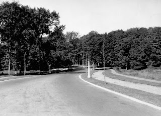
The photos are undated, but we know IPD was first opened to traffic in October of 1923, and we know that St. George's Church was built starting in late 1923, and opened in October of 1924. Since the trees (then just tiny sticks) have their leaves, and since the Church residence house is clearly in early stages of construction (and even St. George's I think is still under construction, though at a later stage), I would place the photo to be sometime in the summer of 1924.
These photos start at Iona Street, going north towards the water. I've also done my best to try to capture the same view in present-day (using the handy Google Streetview tool):
(Note to enlarge any photograph, simply click on it, and a slide show viewer will appear)
 |
| (LAC PA-034411) Island Park Drive looking north at Iona. St. George's Church is visible in the background at right. |
 |
| Roughly the same view in 2016 |
 |
| Same view in 2016 |
 |
| Same view in 2016 |
 |
| That view is slightly harder to replicate in modern day. I used Bing's "Birds-eye" map to get as close as I could. |
 |
| (LAC PA-034414) The photographer has reached the water's edge. There is no bridge yet of course, just a clear view of Riopelle Island, and the many logs washed up on shore. |
 |
| Present-day view. I think the 1924 photo is taken more to the west, but this was as far west as Google Streetview would allow. |
 |
| (LAC PA-034415) A view showing the west half of Riopelle Island, and the photographer's ride parked at the water's edge. |
 |
| (LAC PA-034416) This is a view to the east, with the old abutment to help with spring flooding. |
 |
| Present-day view. Note the original Champlain Bridge approach was located where this Remic Rapids lookout now stands. (More on that in the Kitchissippi Times article linked to above) |
That's the end of that series unfortunately. I wish the photographer had just kept on snapping pictures, and especially had taken more around the Richmond Road area, but I can't complain. At least a few photos are far, far better than none!
But... here is some bonus content. I've culled together a few aerial views of the north end of Island Park Drive from this era (pre-bridge) just to show the gradual development. Some people are not fans of aerial photos, but I love them, as they are great to show details and growth. And I think for the early 1920s, these are still incredible quality, when you consider the primitivity not only of photography, and taking photos from the air, but also of air travel itself.
The first view is from the earliest set of aerial photos I've seen, taken in 1920. There are the three islands, with Champlain Park just a smattering of little cottages at the bottom left. Pontiac is the only east-west running street visible. The white colour is the build-up of logs around the islands, and particularly around the bay:
 |
| 1920 aerial photo |
Here is another aerial view from 1920, actually from the same series, but taken on a different flight path, at a different altitude. I like the detail here. You can see the convent and Richmond Road at the far left. That's Carleton Avenue running from left to right along the bottom. Virtually little habitation west of Carleton:
 |
| 1920 aerial photo |
Here is a view looking north from up high from 1922. You can see Island Park come in to view from the very bottom-left corner, and then veers west after it passes Richmond Road. At bottom right is the very early build-up of the streets of Wellington Village to almost Holland.
 |
| 1922 aerial photo |
Below is a shot from over the water, looking south. Not a really clear photo unfortunately:
 |
| June 15, 1923 aerial photo |
And finally, here is an aerial photo from August of 1925. You can see the first leg of the Champlain Bridge under very early construction; it has reached just to Riopelle Island at this point. Scott Street is at left. It is difficult to see Island Park Drive, it is hidden behind some of the thickly treed parts of Champlain Park:
 |
| August 12, 1925 aerial photo |
I could keep going, but I'll leave the era of the construction and finishing of Champlain Bridge for another time! I hope you enjoyed the photo tour of Island Park Drive in its infancy!


A nice set of photos - thanks!
ReplyDeleteTo replicate the aerial photo from above Clearview, you could try the 3D Google Earth view available in Google Maps.
https://goo.gl/maps/5p32bBvx7YT2
I find this fascinating. Thanks, Dave.
ReplyDelete