But the real history of the land begins in about 1832 with the arrival of the Stewart family. At the time, the Thomson family, who had arrived in 1819, were residing out in Westboro (they later built the gorgeous stone mansion Maplelawn in 1831-33), and Peter Aylen around this time built near the corner of what is now Richmond and Kirkwood. To the east, the Hintons were still 20 years away from arriving, and Robert Reid hadn't yet settled on his farm property. The area, which was then part of rural Nepean Township, was completely undeveloped, isolated and was largely a mix of forest, swamp, and brush. The primitive road to the relatively new military settlement of Richmond went through the area, and combined with the proximity to the Ottawa River and the great Chaudiere Falls, as well as the burgeoning villages of Bytown (Ottawa) and Wrightsville (Hull), the area was appealing for those seeking to establish a new homestead.
 The land, which was known as "Lot 34" of "Concession 1" of Nepean Township had first been granted in 1798 to the daughter of a United Empire Loyalist, but like most of the loyalist grants, the grantees never located to the area. The lots were long, thin pieces of land, typically measuring 200 acres total. In our area, the concession lines were what is now Carling Avenue and Scott Street, and lot lines ran approx. 4-5 city blocks wide. (see map at right). So Concession 1 was the area between Carling and Scott, Concession 2 was the area south of Carling, and Concession A was the area between Scott and the Ottawa River.
The Stewart family acquired lot 34 in 1831 when William Stewart, who was a noted collector of real estate, purchased approx. 200 acres of lot 34 (the north half of concession 1, plus the concession A portion) for £175, giving him all of the land from what is now Java Street north to the River. Through two other deals soon after, he would sell off the land north of Scott Street, and acquire the land south of Java to Carling. Ultimately by 1833, Stewart would own the true 200-acre lot 34 property of concession 1. And once that was settled, he transferred the ownership to his brother Roderick Stewart in 1834.
But that's getting a bit ahead. The Stewart family first came to Canada in 1816. Isabella McLeod Stewart, the recent widow of Ranald Stewart, bravely left the Isle of Skye, Scotland for a new life, and arrived in Upper Canada with her mother, her brother John McLeod, and her ten children. They settled in Glengarry Township, but William Stewart (who was 13 when the family arrived in Canada) came to Bytown in March of 1827 as one of the village's first merchants and tavern keepers. He was elected as one of the original councillors for Bytown in 1828 (and later in 1844 would be elected representative for Russell to the Legislative Assembly of Upper Canada). He helped found the Carleton General Protestant Hospital (which later became the Civic Hospital), and during the 1830s played a role in the Ottawa River timber trade and was a founding member of the Ottawa Lumber Association. In the late 1820s, Stewart began purchasing land throughout the region, adjoining the projected route of the Rideau Canal, including this acreage in the future Wellington Village.
Stewart's purchase of lot 34 in 1831 was the start of what would become a 130-year presence of the family in the neighbourhood.
William's brother Roderick (who was younger than William by one year) first came to Bytown in 1828 when William Stewart required his assistance to run his then-successful tap room for the summer. This proved to be a questionable decision by William, as various sources tell that Roderick had a penchant for alcohol. As the stories go, Roderick was not good with money, nor an overly motivated worker, and his brothers William and Neil carried a significant burden to continually check up on him, assist him financially, and help take care of his family.
In fact it appears the December 9th, 1834 transfer of the lot 34 property from William to Roderick was made in the anticipation of giving Roderick a fresh start in life as a farmer. The official sale price was £200, but it seems doubtful William ever saw much, if any of that sum.
Different sources point to Roderick arriving in the area as early as 1831 or 1832 (perhaps before the official deed transaction was registered). He opened a large farm on his land, and built a grand stone house, which remained in the family until the 1960s. The home was built of cut limestone with hand-hewn timbers. Originally it had a cottage roof, four sides to a peak, but was later replaced with a mansard roof shown in the surviving photograph here. This house was constructed on the east side of what became Julian Avenue, just south of Wellington Street (see further down for more on this house).
.jpg) |
| Stewart Family Home on Wellington Street West (circa 1920) |
 |
| Roderick Stewart |
According
to the book "Looking Back", "Roderick grew into a large man. The
size of his head in his portrait indicates a man with a large frame. After not
having seen Roderick for some time his brother Neil Stewart wrote from
Hawkesbury to his uncle John McLeod, at Lachine on June 20th, 1825: "Roderick paid me a visit lately and was surprised of his enormous size, he told
me he would banter Lancaster from end to end...I know he will be a rattler at
the Ax."
Not long after building his house, Roderick was married to fellow Scot Williamina Ross on October 12th, 1837 in Bytown. Together they would have ten children: Isabella (born, 1838, died in infancy); Alexander (1839), Ranald (1841), Charles (1842), Christina (1844, died in infancy), Isabella (1846, died in infancy), Mary (1849), Wilhelmina (1851), John (1853) and Flora (1855).
 |
| Wilhelmina (Ross) Stewart |
Roderick did seem to have some successful periods farming the land, and it became one of Nepean Township's finest, particularly as the Richmond Road grew in importance. However, he was unable to manage his finances over the long term.
In July of 1846, Roderick's brother Neil Stewart had sent along £8 to William to
forward to Roderick "which I send him to buy flour if in need, or to
assist him in getting a person to help him with his harvest. Give it to him
without delay as he may possibly be in need." and in another letter later
that month wrote: "I merely write to know how Roderick is doing since I
left. I had a note from Charles who states that he has been perfectly sober
since, if so I beg you to give him to understand that you are reconciled to him
in a manner, and to make him feel proud for the stand he has taken, he requires
to be encouraged if he holds out. I forgot to mention to him on parting to give
you a Bill of Sale of all his valuable chattels in consideration of the
mortgage money, he should do it at once. I have written to him to that
effect."
A letter from William to his uncle John McLeod in 1847 further noted: "My own expenses are increasing and my business is not near so good as it was a few years back... at any rate I have considerable drawback on my energies in the person of Roderick, who seems to be entirely regardless of his own interests...he can work very well if he chooses...but it seems as if he had abandoned all industry...since he lived on his farm I don't believe he has been 48 hours at any time at his home...he has neither intellect or industry...he owes me now upwards of 400 pounds and I would be glad to lose that amount, if I saw him in a way of doing any good."
These letters thus explain why in 1856, William's will transferred ownership of lot 34 to Roderick's two sons Alexander and Ranald. Roderick had (unofficially) signed over ownership of his land to William, and thus when William passed away, he took care of his nephews by granting them each one half of the lot 34 property (Ranald the west half, Alex the east; the split would have run just east of Clarendon). Roderick was still alive and living in the stone house, but rather awkwardly, his eldest sons now owned his farm.
 |
| Part of an article in the Ottawa Times newspaper of 19 April 1866 mentioning the Stewart's range. |
The Stewarts also operated a popular rifle range on the property during the 1860s, where citizens of Ottawa could practice their shooting in the rural vastness.
In 1873, the Stewart brothers married a week apart. On November 12th, 1873, 32-year old Ranald married Fannie Russell Eaton, while 34-year old Alexander married Constance Anna Pinhey (1849-1932), daughter of Horace Pinhey and granddaughter of the well-known politician and mill-owner Hamnett Kirkes Pinhey (who had established the settlement of Horaceville at Pinhey's Point) on November 19th, 1873.
Just prior to the wedding, Ranald built a fairly large two storey, seven room brick house on his half of lot 34, which was located approximately 100-200 feet south of Wellington Street (then still called Richmond Road, as it was until after Hintonburg was annexed to the City of Ottawa in December of 1907), on what is now Granville Avenue. The house would remain in this location for approximately 20 years. Alexander also built a one-and-a-half-storey house on the property within a year of his marriage. This wood-frame house was also seven rooms in size, and was located just south of Wellington near Warren Avenue.
Neither couple wasted much
time in beginning their family, as in August of 1874, both Constance and Fannie
Stewart gave birth to children just ten days apart. Ranald and Fannie Stewart
had a daughter Fannie Theresa Stewart (born August 4th, 1874), the
first grandchild for Roderick and Williamina Stewart. Then on August 14th, Alexander and Constance Stewart had a son Horace Pinhey Stewart. Fannie would
live into her 60s; however Horace would pass away at the young age of 9 due to
rheumatic fever affecting his heart.
 |
| Map showing the approximate locations of the three houses built on the Stewart farm. |
The first attempt to develop the farm occurred in 1874 when an Ottawa-based real estate prospector Hector McLean purchased all of the Stewart brother's property north of Wellington Street. His endeavour, however, failed and the Stewarts reacquired almost all of the land (more on McLean and his subdivision in a future blog post!)
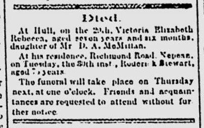
Patriarch Roderick
Stewart passed away on December 29th, 1879, at the age of 75.
 |
| Roderick's obituary from the Ottawa Citizen of December 31st, 1879. |
Following her husband's death, Williamina remained in the main family home, with her unmarried children Mary, John and Flora. Son Charles had married and moved out of the home prior to 1879, and daughter Wilhelmina married Provincial Land Surveyor Robert Sparks in 1877 and relocated to Gloucester Township. Son John around this time would relocate temporarily to Manitoba and Saskatchewan to work as one of the federal government's pioneer surveyors He had studied surveying with his brother-in-law Robert Sparks.
 |
| Alexander Stewart, portrait. |
On September 14th, 1882, tragedy struck the Stewart family as Wilhelmina's husband Robert Sparks,
then only 44 years old, was a passenger on the steamer "Asia" of the
Great Northern Transit Line which sunk in Georgian Bay after a severe storm hit
and quickly sank the overfilled boat. Only one lifeboat containing two
survivors made it to shore. Robert and his brother Frederick were among the
over one hundred passengers to lose their lives in the sinking. Wilhelmina and
her three young children moved back on to the family homestead at this
time.
On the 1884 assessment roll for the Township of Nepean (an incredible research tool that luckily has been preserved from the past), the Stewart family farm on lot 34, was listed as
being comprised of 80 acres cleared, 60 acres of woodland, 20 acres of "swamp,
marsh or waste land", and 7 acres of "fall wheat". Future assessment rolls would also indicate approximately 10 acres of orchards.
Though the Stewarts succeeded in farming in Wellington Village, there was still by the late 19th century very little built up in the area. Winters were harsh, difficult times, where neighbours were dependent on each other. The arrival of the trains helped grow the area (the Canada Central Railway - later the CPR - where the Transitway now exists in 1870; the Ottawa, Arnprior and Parry Sound Railway - later the Grand Trunk - where the Queensway now exists in 1893; and the Ottawa Electric Railway, now the Byron Linear Park, in 1900), and soon many of the farmers and landowners in the area began subdividing their properties to sell individual builder lots. Alexander Stewart followed suit, and registered a plan in 1892 for the land north of Wellington Street. Though his intent was to sell lots and profit
from the sale of lots in his subdivision, during the brief time he owned this
land before selling it in 1893, he sold only one lot.
In 1893, Alex Stewart capitalized on the growing popularity of the area, and sold his entire lot 34 holdings to a land syndicate, the Ottawa Land Association (led by the popular Andrew Holland), for an incredible sum (for the era) of $30,000. Following the sale, Alexander Stewart used his significant wealth to purchase a large 16-acre property on rue Gamelin in Gatineau, which featured the historic mansion Fairview House, which he renamed Balmoral Lodge. There he grew flowers and fruits in his retirement years.
 |
| Article from the Ottawa Journal January 27, 1888. |
In 1893, Alex Stewart capitalized on the growing popularity of the area, and sold his entire lot 34 holdings to a land syndicate, the Ottawa Land Association (led by the popular Andrew Holland), for an incredible sum (for the era) of $30,000. Following the sale, Alexander Stewart used his significant wealth to purchase a large 16-acre property on rue Gamelin in Gatineau, which featured the historic mansion Fairview House, which he renamed Balmoral Lodge. There he grew flowers and fruits in his retirement years.
Only the original stone house
remained in the possession of the family. Alex Stewart's widowed mother
Williamina Stewart (then 81 years old) remained in the home with her youngest
daughter Flora, her daughter Mary and Mary's husband William Hanright. Records in the mid-1890s are
spotty, but it appears soon after the OLA purchased the property, the wood and brick houses built by the Stewart brothers during the early 1870s were
demolished or abandoned in place. There are no records of any tenanted houses
on the property after 1893.
Notable from 1893 was that Hintonburg, for political reasons, became independent from Nepean Township. The primary reason for this was that the Ottawa Electric Railway (whose directors also directed the OLA) wished to run the tracks for the streetcars through Hintonburg, which the Township did not support. By gaining independence, Hintonburg could allow the tracks to be laid. When deciding the borders of Hintonburg, it was decided the village would reach as far west as the Stewart property, the border between lots 33 and 34, which we know now as Western Avenue, so named because when independent Hintonburg became part of the City of Ottawa in 1907, Western Avenue was its western border.
Notable from 1893 was that Hintonburg, for political reasons, became independent from Nepean Township. The primary reason for this was that the Ottawa Electric Railway (whose directors also directed the OLA) wished to run the tracks for the streetcars through Hintonburg, which the Township did not support. By gaining independence, Hintonburg could allow the tracks to be laid. When deciding the borders of Hintonburg, it was decided the village would reach as far west as the Stewart property, the border between lots 33 and 34, which we know now as Western Avenue, so named because when independent Hintonburg became part of the City of Ottawa in 1907, Western Avenue was its western border.
 |
| 1928 aerial photograph of Julian running into Wellington. That's the Stewart's house on the east side of Julian, with the pathway running to Wellington. 12 Julian Ave is directly across the street, and the house which is now part of the Cube Gallery building is also there (looking straight down Julian). |
 |
| Article from the Ottawa Journal, June 9, 1961, announcing the unfortunate sale of the home and property. |
 |
| A current aerial photo of the former Stewart house location. The house was situated where the parking lot now exists for the tall "The Julian Apts" building. |
I grew up at 45 Edina Street, which appears to be just west of the property outlined on the first map. The western boundary of the Stewart property would have been the boundary between Ottawa and Nepean at one point, which is clearly evident in the location where the sidewalks end on the streets Edina, Geneva, Helena, Faraday, Iona, Java, Kenora and Byron. I have heard rumours from at least two sources that the naming of these streets all intersecting Clarendon (Edina through Kenora) was after a family of sisters. So far, I have found nothing substantial in the City of Ottawa archives nor the Ottawa Room at the Ottawa Public Library. You hint there is another article coming about this area. I look forward to its release. Thanks for your fantastic work.
ReplyDeleteI spent my first four years (Dec., 1947- May,1952) living in that stone house on Julian Avenue. My mother was Judith Crawley (nee Sparks) and after our family built on the Meach Lake Road in Quebec my aunt Cecily Charnovska (nee Sparks) lived there until 1961.
ReplyDeleteIt really is a shame that they tore down the original farmhouse!
ReplyDelete