Sunday, January 18, 2015

Street Profiles: The History of Stirling Avenue

This is the first of what I hope will be a popular regular series that I plan to do on this blog. Once a week, I plan to run a profile of a street in Kitchissippi. I'll write about it's earliest beginnings, how it was born, when it was first built on, and discuss some of it's significant residents, houses, buildings and businesses.

For my first street profile, I have selected what I consider to be one of the more interesting streets in the history of the area. But it isn't one you would have expected. I was also inspired to choose this street by the suggestion of a high school friend who realizes that the street still has meaning to her, even years after her family has since moved away. Stirling Avenue is a relatively short street that kind of bisects Hintonburg between Wellington and Scott, and has an unbelievable amount of interesting history stuffed into its 1,400 foot length. A perfect representative of the wild and crazy history of Hintonburg itself.

Current Street Name: Stirling Avenue
Former Street Name: was known  as "Centre Street" up until 1908
First established: 1873
Name meaning: According to "Ottawa Old & New", it was named after Stirling, a City in central Scotland.
How named: Hintonburg was annexed to the City of Ottawa in December of 1907, and many streets required renaming. This was done by the Board of Control in 1908, likely under the recommendation of the outgoing Hintonburg town council.

Early days:
The history of a large portion of Hintonburg ties directly back to the land of former Scot Mr. John Anderson, who in March of 1831 acquired 100 acres in the north half of lot 36, concession 1 (many years before it was Hintonburg). The Andersons settled on the land, before John died in 1849. His widow, the former Janet Gilmour began selling off portions in the 1850s, before filing one of the earliest subdivision plans in Carleton County. She registered Plan 14, at the age of 80 in September of 1861, just a month prior to her death. The Plan was an interesting one, as it split the remaining 80 or so acres of her land, into 8 blocks (numbered with roman numerals). Each block had a different width and length, which is very curious. Anderson then transferred a block to each of her eight children. At the time, one would not have envisioned Hintonburg becoming as thickly populated as it is now, and the intention was likely mostly to provide these parcels of land, 6-10 acres in size apiece, for her children to establish either small farms or large homesteads in the rural setting outside of Ottawa.

Block VI (6), comprising a little over 7 acres, was given to daughter Agnes (married name Stewart). Agnes did not built on the lot, but maintained it for 10 years before selling in 1871 to Frances Magee, a widow and early Nepean Township settler who acquired a number of pieces of land. She was a trailblazer indeed, being a female real estate prospector in this era. It was in May of 1873 that Magee laid out what was registered as "Plan 43" at the Carleton County Registry Office. As each land-owner was free to lay out their subdivision as they wished, Magee chose to simply run a thin street down the center of the lot, and offer lots on either side. The street was called "Centre Street", and a total of 43 lots were drawn up, most being of 99' deep and 66' wide.

The original Plan 43 (Richmond Road at left, Scott at right. The entire
plan is essentially the full length of Stirling Avenue)

This background is part of a very detailed history of the early days of Hintonburg, but is excellent evidence of why the neighbourhood has a very unique layout of streets and lots. Essentially, Richmond Road existed well before any development began, and all growth happened around it's existing route. But as the area developed through a series of individual packets of property that were stitched together into the tapestry that became Hintonburg, it speaks to the character of the neighbourhood that makes it such an appealing place to live, with such an interesting history.

Magee conducted lot sales through her agent James Clark until her death in 1883. The lots fronting on the popular Richmond Road sold immediately in 1873. Richard Woodland, a butcher, purchased lots C, D, E, and 1 at the northwest corner of Richmond Road; while Peter Harvey, a blacksmith, purchased lot A. These lots were sold for roughly $100 apiece.

The Scottish-born Peter Harvey would be the first to build on the plan, constructing a small 1 1/2 storey wood-frame blacksmith shop fronting Richmond Road just east of the corner of Stirling (approximately now where the Al Jazeerah shop exists at 1101 Wellington) sometime in 1874-1875. The blacksmith shop would remain in this location until about 1910, later operated by David Moodie (1877-1890) and Thomas Blanchfield (1891-1910).

The other businesses fronting onto Richmond Road on Plan 43 would be built soon after as well. Magee House (the wonderful stone house still standing at 1119 Wellington) was built around 1880, and Francis H. Gilchrist's shop at 1111 Wellington (now Heaven's to Betsy) was built in the mid-to-late 1880s.

However the first houses that actually fronted onto Stirling Avenue itself were constructed between 1876 and 1877, when established builder Samuel McArthur built a larger 1 1/2-storey semi-detached house on lot 3 (formerly 108-110 Stirling, demolished in the 1990s, now the location of the newer row townhouses at 110 Stirling), while stonemason Richard Mathews built a smaller house on the north half of lot 5 (now the site of 92 Stirling), which was demolished sometime between 1902-1912.

77 Stirling Avenue, which was restored
beautifully in 2008-09, the oldest home
on Stirling Avenue, now 133 years old.
The oldest home built on Stirling still existing today is 77 Stirling, on lot 32, built by Thomas Mathews in 1882. He would also build the house at 85 Stirling (which still remains today) a few years later. Mathews was a stone mason, and the brother of Richard Mathews, who had built across the street.

Development occurred quickly on Stirling Avenue, indeed as it had throughout Hintonburg during the boom of the late-1880s. By 1892 there were 32 completed houses on the street (compared to just 5 in 1885).

Businesses on Stirling Avenue:
The 1912 Fire Insurance Plan,
showing the "Moving Picture
Theatre" on Stirling Avenue.

No history of Stirling would be complete without mentioning the infamous Stirling House tavern and hotel, which operated at the south-east corner of Armstrong and Stirling from 1935 until the early 1990s. Part of the building actually began life as a movie theater built between 1911 and 1912. George Ventura who would go on to become a projectionist for 40 years in Ottawa theaters operated the "West End Theatre" at 123 Stirling Avenue during the era of silent films. The small 1-storey wood building must have been an incredibly eye-opening site to visit for Hintonburg residents while it was open from 1911 until about 1915.

A rare ad from the Ottawa Journal newspaper on
October 22nd, 1913 promoting the Theatre.


The 1948 Fire Insurance Plan,
showing the Stirling Hotel.
The site would be used for various purposes over the next 20 years, including as an auto garage, paint shop, and as a butchers shop! In fact it was a butcher by trade, Joseph Bonneville, who had been operating his butcher shop out of the building in the early 1930s while residing in the small house next door at 125 Stirling, who created the Hotel. Bonneville took out a building permit in August of 1935 in order to demolish his small house, and expand the existing former theatre building into a bricked 2-storey and double-wide hotel and tavern. By early 1936, the Stirling Hotel was open for business.

For those of you unfamiliar with the lore of the Stirling House, it is absolutely legendary in Hintonburg. While I was much too young to have ever been able to visit the tavern while it was open, I do remember driving by in my childhood, and hearing some of the stories about it from my Dad and grandfather. The newspaper archives are chock-full of unbelievable stories as well. It seems that barfights were practically a daily occurrence, and the local police were regularly called in for disturbances big and small.

The former Stirling House. (Photo borrowed from the blog:
http://ottawaplaces.blogspot.ca/)

After finally closing down in the early 1990s, when the Hintonburg transformation was just in its early stages, the building sat idle for many years, until the CCOC purchased it for $2, renovated it and converted it in to housing. So it is thanks to the CCOC that we can still walk by the building today and reminisce, and have this piece of history intact from such a unique and important part of Hintonburg's past.

Other businesses have existed on Stirling Avenue over time. As was common in the late 19th and early 20th century, small grocery shops were operated out of front living rooms. Many of these came and went over the years, often not lasting more than a year or two. However, a couple of stand-out businesses did remain longer term and are worth memorializing here.

ad for Verdon's grocery from the Ottawa
Journal, November 28th, 1924.
In 1905, Jean-Baptiste Verdon opened a large grocery store, butcher shop and wholesale tobacco business out of his home at 38 Stirling Avenue. He established quite a complex of different small additions to the three houses at 34, 36 and 38 Stirling, it must have been quite a maze to investigate. J.B. Verdon passed away in 1938, but his son Conrad kept the family business running until the late 1960s. The photo below shows the business as it was just before they were demolished. The site is now a community park that runs the full length between Stirling and Carruthers.

At left is an old ad from the Grocery & Butcher Shop from 1924.


Verdon's Grocery, March 1965
(CA-24662 - City of Ottawa Archives)

The building on the north-east corner of Stirling and Armstrong (105-107 Stirling) has long been the site of various mercantile endeavours. Auguste Roy built the house around 1891, and remained there until he died at the amazing age of 98 in 1958. He operated a cab company out of the home from 1889 until 1939 (I guess he would have started off with horses before switching to automobiles as the times changed). He also operated a restaurant out of the building commencing in the late 20s or early 30s, which was taken over by local businessman Joseph P. Nolan after his retirement in 1939. It later became the Stirling Grocery Market, and Cal's Confectionery. By the mid-1950s it became the Brentwood Vacuum Cleaners and Repairs shop, Morrison Refrigeration in the 60s, and likely had a few other names and purposes before converting to exclusively residential sometime in the 1980s.


Other landmarks & notable locations on Stirling Avenue:

In 1933, the St. Francois D'Assise Separate School opened up at 12-24 Stirling Avenue, providing a larger space than what the school had previously had at the Irving Avenue location. This school was used as an art gallery by the late 1980s and became the Odawa Friendship Centre in 1996, but of course is now under renovation to become part of a larger condo structure.

To the north of the school, where the gymnasium was just recently demolished, used to be a row of houses built in the mid-1890s as rental housing. They actually managed to stick around until the 1960s, and were literally falling apart when the City of Ottawa forced their removal as part of their Urban Renewal initiative of the late 1950s. The photos below were taken in 1960 shortly before they were demolished. Both a view from the front of the house and rear are shown.


2-4-6-8-10 Stirling Ave in 1960 (front view)
(CA-20644 - City of Ottawa Archives)

2-4-6-8-10 Stirling Ave in 1960 (rear view)
(CA-20645 - City of Ottawa Archives)

And this below is just another cool old vintage photo I once found of 82 and 84 Stirling Avenue in their 1954 glory. While doing final editing on this blog, I was actually a little surprised to see the house still exists today, nicely refinished! This house was also built by Richard Matthews, sometime around 1888-1891.


(CA-24663 - City of Ottawa Archives)


To conclude this look at Stirling Avenue, I thought I would do two things. Firstly, I wanted to write a paragraph on the original 98 Stirling Avenue, which has since been replaced with a new build. This was the house which my old high school friend had still felt a connection to, and in doing a quick research of its history, found it to be a perfect representation of a Hintonburg home. The original 98 Stirling was built during the winter of 1888-1889 by Samuel McArthur (the same builder mentioned earlier who had built one of the first two homes on the street in 1876; he also had built the original town hall on Parkdale and several other notable buildings in Hintonburg). McArthur was building up quite a collection of properties which he rented out to tenants. The house was given the number 59 Centre Street (interestingly, prior to the annexation to Hintonburg, all of the houses on Stirling were numbered in the opposite way, with odd numbers on the west side, even numbers on the east). The first occupants were Edmund Thompson, a 36-year old millwright from Lochaber, Quebec, his wife Hannah Scobie, and their five children. Hannah died in April of 1892, giving birth to their sixth child. The Thompsons moved out around 1894, replaced by Leonard Sauve, a lumber culler, and his young family. This began a chain of events typical of homes in the area, where the houses were sold often, and occupants changed practically every year or two. To list every owner and occupant of the house would take literally paragraphs. But the people share almost all of the same basic characteristics: francophone, working class, young with growing large families, such as Eustache Lacroix (1900-1906), Louis de Bourgogne Routhier (1906-1910), and Jean Fissiault (1910-1913).

The Blais family of 98 Stirling Avenue, circa 1910
(photo source: Ancestry)
Most notably, in April 1913 the house was purchased by Wilfrid Blais for $650. Wilfrid was a carpenter, and the director of the Catholic Order of Foresters. He and his wife Alvina would remain in the house for 34 years, raising their TWELVE children, and (at the time of Wilfrid's death in 1944) 36 grandchildren and 7 great-grandchildren.

The Blais family sold in 1947 to Adelard and Alexandrine Dinelle. Adelard was the proprietor of Dinelle Rug Cleaners at 839 Somerset West. The Dinelle family would remain until November of 1980, selling for $25,250 to Daniele Bourbeau, who flipped it a little over two years later in January of 1983 to the Clarke family for $47,000. The original house was replaced between 2002-2005.

To close, I thought I would attach a few interesting newspaper articles about Stirling Avenue from various points in time which show just how far we've come in 100 or so years, and how crazy some of Hintonburg's past really was. Click on any of the articles below which will load up a filmstrip where you can view them in a larger size. Cheers and enjoy!

Ottawa Journal - September 22, 1909

Ottawa Journal - January 15, 1913

Ottawa Journal - March 7, 1913

Ottawa Journal - February 17, 1925

Ottawa Journal - January 26, 1935

Ottawa Journal - May 12, 1959 

Ottawa Journal - July 11, 1961

Tuesday, January 13, 2015

This Just In! Island Park Drive 1927

Just had to share this photo this morning! While diving through the depths of the National Aerial Photo Library on Booth Street last week (a favorite way to spend an afternoon every couple of months), I uncovered this gem of a photograph from June of 1927 (click on it to expand it in a pop-up window):


The photo is a view of Island Park Drive when it was new, looking south towards Scott Street from above the River. St. George's Church is visible towards the top in the centre, just below the belly of the airplane. The dusty lane that is barely there near the bottom of the photo crossing Island Park is a very early version of Clearview Avenue.

Here is a bit of an aerial shot of present-day, showing the same curve in Island Park, and the area now built up all around it.


Thursday, January 8, 2015

Broadview School and the heritage designation question

This week's issue of the Kitchissippi Times released today includes an opinion/history piece I wrote on the heritage question for Broadview School. Please check it out at http://kitchissippi.com/broadview-school-heritage/

And while I'm self-promoting, you can also view a few of the other recent history pieces I've provided the Kitchissippi Times and Ottawa Citizen at my website: http://housestory.co/press.html

The Island Park Drive at Richmond Road traffic circle

Tonight I'm sharing one of the coolest secrets of Kitchissippi's past. It's one of the topics that garners the most attention and curiosity from visitors to my little booth when I set up at Westfest or ArtsPark and share the old photos.

From 1929 until 1957, the intersection of Island Park Drive and Richmond Road, arguably one of the busiest of the west end at the time (and even now), features no traffic lights or stop signs, but instead was controlled via a traffic circle! 

Here are two shots of the traffic circle when it was first installed in the summer of 1929. The top shot is shown looking as if you were standing in the middle of Island Park Drive looking north, with Richmond Road running left to right in front of you. You can see 351 Island Park Drive in the background, and that car at the right edge would have been parked just about in the lot of the old Proshine Car Wash. (click on the photo to have it open in a larger view).

(CA-19227 - City of Ottawa Archives)

Here is a shot from the opposite angle, looking south down Island Park Drive. You can see the roof of the then five-year-old St. George's Church on the left. Very little was built up on Island Park Drive at the time, and the trees are all young.

(CA-19228 - City of Ottawa Archives)

Island Park Drive was opened up in 1923 by the Ottawa Improvement Commission (a forerunner of the Federal District Commission and later the N.C.C.) as the "West End Driveway", but at the time only ran as far as the water's edge at the Ottawa River, by the Remic Rapids. In September of 1927, the Champlain Bridge was opened to continue the Driveway, but it only extended over the three islands, not all the way across to Quebec yet. It took a year of impressive construction work to finish the bridge to the Quebec side. Not surprisingly, it increased traffic in the area substantially, not to mention that real estate was absolutely booming at this time (Wellington Village was probably 60% constructed between 1927 and 1933; Island Park Drive itself began having houses built on it; and Hampton Park, Piccadilly/Mayfair, Champlain Park, etc. were all in the peak period of development). And let's not forget that automobiles were still relatively new, and certainly the ability for the common citizen to afford and use one was still new - infrastructure for vehicular traffic was still in its infancy. If we thought the growth of Kitchissippi at present was bad, you can imagine how crazy it would have been in 1929. So the traffic circle was pitched as a way to control the traffic, as there were increasing numbers of accidents and back-ups at the intersection.

Ottawa Journal - September 5, 1929

At left is an article published in the Ottawa Journal not long after the roundabout was installed, extolling the virtues of traffic circles. The author of this article was certainly a strong proponent of this new strategy in traffic control!

Check out a vintage aerial photo from 1933 showing the traffic circle in use. (Also notable is how empty the Island Park-Richmond intersection is at the time! The Cities Service Oil Co. station is there at the north-east corner, but within a few years two more gas stations would open on the south corners. and an ice cream parlour would open on the north-west corner (but more on all this in a future blog!).


An aerial photo from 1933 showing the traffic circle at Island Park (running top to bottom)
and Richmond Road (left to right). St. George's Church is visible at bottom right, between
Piccadilly and Mayfair streets.

Finally, the traffic circle was removed in 1957, to be replaced by traffic lights. Interestingly, the removal of the circle was a debacle throughout it's final year. On boxing day of 1956, a 24-year-old police constable skidded into the circle and fractured his skull; in March, Sunday drivers taking advantage of the first nice weekend of Spring tied up Island Park Drive for hours, which was blamed on the traffic circle; in April a pedestrian was struck crossing the circle and was taken to hospital; during the first week of July the FDC began removing the earth and vegetation from the middle of the circle prematurely, before City Council had officially approved the removal of the traffic circle, resulting in the FDC having to formally apologize, but also leaving the circle in an ugly, half-demolished state for several months; and in late July Alderman Frank Boyce crashed into the circle and broke his leg while blinded by the lights of an oncoming car. 

The circle was finally completely demolished in late September (at a cost of $8,500, shared between the FDC and City of Ottawa), and was replaced by what some community members complained was an "asphalt jungle", an eyesore in comparison to the attractive centerpiece of flowers and grass which had existed in this spot for the previous 28 years. Unfortunately, little has changed in the 58 years since, it is still a relatively boring intersection. Though the changes made about 10 years ago to remove the mini-islands and turning lanes have added a bit of extra greenery to the intersection, it came at the loss of functionality for cars. With the new Convent condos now being populated and more cars added to the area every day, it is only getting worse. And ironically, the City is not only revisiting the early 20th century transportation methods by re-laying rail track that was pulled up in the latter half of the century, they are even coming full circle (please excuse the pun) when it comes to re-adding roundabouts in various spots in the City (Gatineau certainly loves them too, for those familiar with driving on the Quebec side). Maybe a return to a traffic circle at Island Park Drive and Richmond might be what we need to solve our traffic woes in the area???  :)  

Wednesday, January 7, 2015

Your input is always appreciated!

The first few posts of the new blog are up, and I hope you enjoy the content. Please bookmark this site and check back once in awhile. I won't be able to put up new posts every day, but it is my intention to try to post something up at least once or twice a week.

It is my hope that some of the posts may, over time, be commented on by visitors to the site. If you have something you can add to the discussion, some information, an old photograph, etc.,  I definitely encourage you to contribute to the topic. I do not profess to be an expert on all topics related to Kitchissippi history, and for many subjects it can be quite a challenge to find details. So please do feel free to add in what you can, I appreciate.

As well, if you have any requests for topics to be covered, or if you have any questions about anything Kitchissippi-history related, please feel free to suggest away! I'm happy to try to solve any mysteries you might have, help solve a lingering question, or explore the history of a building, property or person. Usually the most interesting mini-research projects I get into are the ones that are borne out of a random question or comment I get at Westfest or Taste of Wellington West.

Thanks so much for reading!

A map of Kitchissippi...from 1879

One of the greatest series of books ever published has got to be the Belden Atlas series of the 1870's. And I am very thankful for it. I'm not exactly sure why this series was made, but commencing in the mid-1870's a series of approximately 40 county atlases were produces for many of the counties in Ontario, Quebec and out east. Belden was the largest producer of these atlases, including the one for Carleton County, which it produced in 1879. This mammoth sized hard-cover book included various maps of North America, Canada, Ontario, Carleton County, and most importantly, the various townships and populated villages and cities within it. Also included were some very cool detailed drawings of the homesteads of some key residents of the county. The book also included written histories of the townships, and biographical information on some key figures.

The borders of Carleton County very interestingly mirror almost exactly what the City of Ottawa boundaries are today (thanks to the various amalgamations), except for an added bit of the original County of Russell, Cumberland Township. Nepean Township was one of 10 townships within it, and had boundaries of rougly Ottawa River on the north, the Rideau River on the east, approximately along where Bankfield Road and Brophy Drive are today on the south, and approximately where Eagleson Road, March Road, and Hertzberg Road are today through to Shirleys Bay on the west (thanks to Wikipedia for all of that). So now that you have the geography set up, my focus for today is on the Kitchissippi area.

The map is below (for best results, you may want to right-click on it, select "save image as" and save it to your computer so that you can view it in better detail).

To situate you, at top of the map is "Johnston's Mills", which was located just about where Sherbourne Road would run if it continued to the River beyond Byron. At the bottom of the map is the old suburb of "Rochesterville", which is now the Chinatown neighbourhood between Bronson and Preston, and LeBreton Flats can be seen to it's right. The double-line down the left edge represents the concession line, which is Carling Avenue. The pair of double-lines down the centre of the picture represent Richmond Road on the left, and the concession line (which is now Scott Street) on the right. The visible rail line is the old Central Canada Railway (later the Canadian Pacific), which of course is now the Transitway.

Each rectangular square represents one original lot. All the lots between the concession lines (Carling and Scott) were in "Concession 1" and all the lots between Scott and the Ottawa River were in "Concession A". The lots then are numbered from west to east (most lot numbers appear near the concession line on the left edge; from 31 up to 39). The lot-owners in 1879 are identified by name, and below or to the right of their name is the total number of acres owned. Parcels of land which had been already subdivided appear shaded (and those subdivisions had their own smaller maps published in the atlas). Finally, the black squares indicate built structures, and some are labelled as being a post office, mill, or toll house, but for the most part, they are the original farm houses of each lot.


A few landmarks to help locate streets and areas of 2015: Skead's Saw Mill at the river's edge near the top of the map is where Westboro Beach and Kitchissippi Lookout are located today (in fact some of the original ruins of the mill can still be seen at the lookout). The "Skead's Mills P.O." (post office) would be located at the corner of Churchill and Richmond (Skead's Mills being the original name of Westboro). The borders of lot 33 (Daniel Keyworth Cowley's property) are Patricia Avenue at the top and Western/Granville at the bottom (that's the Soeurs de la Visitation Convent represented in the little square of land within lot 33 marked "G.W.E. Est", for George W. Eaton, the owner of the Convent when it was known by it's original name 'The Elms'). The lot line between lots 35 and 36 would be Parkdale Avenue, and the layout of many of the streets of Mechanicsville, Hintonburg and Bayswater remain unchanged 135 years later.

Hope you've enjoyed checking out this map!

Wellington Village's pioneer Stewart family

The history of Wellington Village is probably the least-known history of any pocket of central Ottawa that I have come across. This area has an incredible history, unique to the communities to its east and west (Hintonburg and Westboro). Have you noticed while walking or driving through the area that there is no building in this area older than the early-1920s? I find there is a very distinct look to a house built prior to this time, particularly those built in the 19th century. I haven't studied architecture too deeply (it's on the bucket list though), so if I had that background, I'd probably be able to cite to you precisely what changed after WWI in home construction, improved materials, design, etc. But we know they are there; you can see them all over Hintonburg, on Bayswater, throughout Mechanicsville, on Parkdale, etc. And similarly, you see them on Hilson Avenue, on Churchill, here and there throughout Westboro. But nothing between Holland Avenue and Island Park Drive. There is good reason for this. Wellington Village (and the communities to the immediate north - Tunney's Pasture - and the immediate south - Elmdale) existed as a family farm for 60 years before being taken over by a real estate syndicate who sat on the vacant land for 30 years, patiently waiting for the values to go up.

But the real history of the land begins in about 1832 with the arrival of the Stewart family. At the time, the Thomson family, who had arrived in 1819, were residing out in Westboro (they later built the gorgeous stone mansion Maplelawn in 1831-33), and Peter Aylen around this time built near the corner of what is now Richmond and Kirkwood. To the east, the Hintons were still 20 years away from arriving, and Robert Reid hadn't yet settled on his farm property. The area, which was then part of rural Nepean Township, was completely undeveloped, isolated and was largely a mix of forest, swamp, and brush. The primitive road to the relatively new military settlement of Richmond went through the area, and combined with the proximity to the Ottawa River and the great Chaudiere Falls, as well as the burgeoning villages of Bytown (Ottawa) and Wrightsville (Hull), the area was appealing for those seeking to establish a new homestead.

The land, which was known as "Lot 34" of "Concession 1" of Nepean Township had first been granted in 1798 to the daughter of a United Empire Loyalist, but like most of the loyalist grants, the grantees never located to the area. The lots were long, thin pieces of land, typically measuring 200 acres total. In our area, the concession lines were what is now Carling Avenue and Scott Street, and lot lines ran approx. 4-5 city blocks wide. (see map at right). So Concession 1 was the area between Carling and Scott, Concession 2 was the area south of Carling, and Concession A was the area between Scott and the Ottawa River.

The Stewart family acquired lot 34 in 1831 when William Stewart, who was a noted collector of real estate, purchased approx. 200 acres of lot 34 (the north half of concession 1, plus the concession A portion) for £175, giving him all of the land from what is now Java Street north to the River. Through two other deals soon after, he would sell off the land north of Scott Street, and acquire the land south of Java to Carling. Ultimately by 1833, Stewart would own the true 200-acre lot 34 property of concession 1. And once that was settled, he transferred the ownership to his brother Roderick Stewart in 1834.

But that's getting a bit ahead. The Stewart family first came to Canada in 1816. Isabella McLeod Stewart, the recent widow of Ranald Stewart, bravely left the Isle of Skye, Scotland for a new life, and arrived in Upper Canada with her mother, her brother John McLeod, and her ten children. They settled in Glengarry Township, but William Stewart (who was 13 when the family arrived in Canada) came to Bytown in March of 1827 as one of the village's first merchants and tavern keepers. He was elected as one of the original councillors for Bytown in 1828 (and later in 1844 would be elected representative for Russell to the Legislative Assembly of Upper Canada). He helped found the Carleton General Protestant Hospital (which later became the Civic Hospital), and during the 1830s played a role in the Ottawa River timber trade and was a founding member of the Ottawa Lumber Association. In the late 1820s, Stewart began purchasing land throughout the region, adjoining the projected route of the Rideau Canal, including this acreage in the future Wellington Village.

Stewart's purchase of lot 34 in 1831 was the start of what would become a 130-year presence of the family in the neighbourhood.

William's brother Roderick (who was younger than William by one year) first came to Bytown in 1828 when William Stewart required his assistance to run his then-successful tap room for the summer. This proved to be a questionable decision by William, as various sources tell that Roderick had a penchant for alcohol. As the stories go, Roderick was not good with money, nor an overly motivated worker, and his brothers William and Neil carried a significant burden to continually check up on him, assist him financially, and help take care of his family.

In fact it appears the December 9th, 1834 transfer of the lot 34 property from William to Roderick was made in the anticipation of giving Roderick a fresh start in life as a farmer. The official sale price was £200, but it seems doubtful William ever saw much, if any of that sum.

Different sources point to Roderick arriving in the area as early as 1831 or 1832 (perhaps before the official deed transaction was registered). He opened a large farm on his land, and built a grand stone house, which remained in the family until the 1960s. The home was built of cut limestone with hand-hewn timbers. Originally it had a cottage roof, four sides to a peak, but was later replaced with a mansard roof shown in the surviving photograph here. This house was constructed on the east side of what became Julian Avenue, just south of Wellington Street (see further down for more on this house).
Stewart Family Home on Wellington Street West (circa 1920)


Roderick Stewart
According to the book "Looking Back", "Roderick grew into a large man. The size of his head in his portrait indicates a man with a large frame. After not having seen Roderick for some time his brother Neil Stewart wrote from Hawkesbury to his uncle John McLeod, at Lachine on June 20th, 1825: "Roderick paid me a visit lately and was surprised of his enormous size, he told me he would banter Lancaster from end to end...I know he will be a rattler at the Ax."

Not long after building his house, Roderick was married to fellow Scot Williamina Ross on October 12th, 1837 in Bytown. Together they would have ten children: Isabella (born, 1838, died in infancy); Alexander (1839), Ranald (1841), Charles (1842), Christina (1844, died in infancy), Isabella (1846, died in infancy), Mary (1849), Wilhelmina (1851), John (1853) and Flora (1855).

Wilhelmina (Ross) Stewart
Roderick did seem to have some successful periods farming the land, and it became one of Nepean Township's finest, particularly as the Richmond Road grew in importance. However, he was unable to manage his finances over the long term.

In July of 1846, Roderick's brother Neil Stewart had sent along £8 to William to forward to Roderick "which I send him to buy flour if in need, or to assist him in getting a person to help him with his harvest. Give it to him without delay as he may possibly be in need." and in another letter later that month wrote: "I merely write to know how Roderick is doing since I left. I had a note from Charles who states that he has been perfectly sober since, if so I beg you to give him to understand that you are reconciled to him in a manner, and to make him feel proud for the stand he has taken, he requires to be encouraged if he holds out. I forgot to mention to him on parting to give you a Bill of Sale of all his valuable chattels in consideration of the mortgage money, he should do it at once. I have written to him to that effect." 

A letter from William to his uncle John McLeod in 1847 further noted: "My own expenses are increasing and my business is not near so good as it was a few years back... at any rate I have considerable drawback on my energies in the person of Roderick, who seems to be entirely regardless of his own interests...he can work very well if he chooses...but it seems as if he had abandoned all industry...since he lived on his farm I don't believe he has been 48 hours at any time at his home...he has neither intellect or industry...he owes me now upwards of 400 pounds and I would be glad to lose that amount, if I saw him in a way of doing any good."

These letters thus explain why in 1856, William's will transferred ownership of lot 34 to Roderick's two sons Alexander and Ranald. Roderick had (unofficially) signed over ownership of his land to William, and thus when William passed away, he took care of his nephews by granting them each one half of the lot 34 property (Ranald the west half, Alex the east; the split would have run just east of Clarendon). Roderick was still alive and living in the stone house, but rather awkwardly, his eldest sons now owned his farm.

Part of an article in the Ottawa Times newspaper
of 19 April 1866 mentioning the Stewart's range.
The Stewarts also operated a popular rifle range on the property during the 1860s, where citizens of Ottawa could practice their shooting in the rural vastness. 

In 1873, the Stewart brothers married a week apart. On November 12th, 1873, 32-year old Ranald married Fannie Russell Eaton, while 34-year old Alexander married Constance Anna Pinhey (1849-1932), daughter of Horace Pinhey and granddaughter of the well-known politician and mill-owner Hamnett Kirkes Pinhey (who had established the settlement of Horaceville at Pinhey's Point) on November 19th, 1873.

Just prior to the wedding, Ranald built a fairly large two storey, seven room brick house on his half of lot 34, which was located approximately 100-200 feet south of Wellington Street (then still called Richmond Road, as it was until after Hintonburg was annexed to the City of Ottawa in December of 1907), on what is now Granville Avenue. The house would remain in this location for approximately 20 years. Alexander also built a one-and-a-half-storey house on the property within a year of his marriage. This wood-frame house was also seven rooms in size, and was located just south of Wellington near Warren Avenue.

Map showing the approximate locations of the three
houses built on the Stewart farm.
Neither couple wasted much time in beginning their family, as in August of 1874, both Constance and Fannie Stewart gave birth to children just ten days apart. Ranald and Fannie Stewart had a daughter Fannie Theresa Stewart (born August 4th, 1874), the first grandchild for Roderick and Williamina Stewart. Then on August 14th, Alexander and Constance Stewart had a son Horace Pinhey Stewart. Fannie would live into her 60s; however Horace would pass away at the young age of 9 due to rheumatic fever affecting his heart.

The first attempt to develop the farm occurred in 1874 when an Ottawa-based real estate prospector Hector McLean purchased all of the Stewart brother's property north of Wellington Street. His endeavour, however, failed and the Stewarts reacquired almost all of the land (more on McLean and his subdivision in a future blog post!)

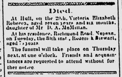
Roderick's obituary from the Ottawa Citizen of
December 31st, 1879.
Patriarch Roderick Stewart passed away on December 29th, 1879, at the age of 75.

Following her husband's death, Williamina remained in the main family home, with her unmarried children Mary, John and Flora. Son Charles had married and moved out of the home prior to 1879, and daughter Wilhelmina married Provincial Land Surveyor Robert Sparks in 1877 and relocated to Gloucester Township. Son John around this time would relocate temporarily to Manitoba and Saskatchewan to work as one of the federal government's pioneer surveyors He had studied surveying with his brother-in-law Robert Sparks.

Alexander Stewart, portrait.
In 1882, Ranald Stewart sold his half of lot 34 to his brother Alex, and moved to Welwyn, Saskatchewan with his family (he and wife Fannie had four children at that time, they would later add an additional four), where he would become one of the pioneer farmers of the province of Saskatchewan over the next 42 years.

On September 14th, 1882, tragedy struck the Stewart family as Wilhelmina's husband Robert Sparks, then only 44 years old, was a passenger on the steamer "Asia" of the Great Northern Transit Line which sunk in Georgian Bay after a severe storm hit and quickly sank the overfilled boat. Only one lifeboat containing two survivors made it to shore. Robert and his brother Frederick were among the over one hundred passengers to lose their lives in the sinking. Wilhelmina and her three young children moved back on to the family homestead at this time.

On the 1884 assessment roll for the Township of Nepean (an incredible research tool that luckily has been preserved from the past), the Stewart family farm on lot 34, was listed as being comprised of 80 acres cleared, 60 acres of woodland, 20 acres of "swamp, marsh or waste land", and 7 acres of "fall wheat". Future assessment rolls would also indicate approximately 10 acres of orchards.

Article from the Ottawa Journal January 27, 1888.
Though the Stewarts succeeded in farming in Wellington Village, there was still by the late 19th century very little built up in the area. Winters were harsh, difficult times, where neighbours were dependent on each other. The arrival of the trains helped grow the area (the Canada Central Railway - later the CPR - where the Transitway now exists in 1870; the Ottawa, Arnprior and Parry Sound Railway - later the Grand Trunk - where the Queensway now exists in 1893; and the Ottawa Electric Railway, now the Byron Linear Park, in 1900), and soon many of the farmers and landowners in the area began subdividing their properties to sell individual builder lots. Alexander Stewart followed suit, and registered a plan in 1892 for the land north of Wellington Street. Though his intent was to sell lots and profit from the sale of lots in his subdivision, during the brief time he owned this land before selling it in 1893, he sold only one lot.

In 1893, Alex Stewart capitalized on the growing popularity of the area, and sold his entire lot 34 holdings to a land syndicate, the Ottawa Land Association (led by the popular Andrew Holland), for an incredible sum (for the era) of $30,000. Following the sale, Alexander Stewart used his significant wealth to purchase a large 16-acre property on rue Gamelin in Gatineau, which featured the historic mansion Fairview House, which he renamed Balmoral Lodge. There he grew flowers and fruits in his retirement years.

Only the original stone house remained in the possession of the family. Alex Stewart's widowed mother Williamina Stewart (then 81 years old) remained in the home with her youngest daughter Flora, her daughter Mary and Mary's husband William Hanright. Records in the mid-1890s are spotty, but it appears soon after the OLA purchased the property, the wood and brick houses built by the Stewart brothers during the early 1870s were demolished or abandoned in place. There are no records of any tenanted houses on the property after 1893.

Notable from 1893 was that Hintonburg, for political reasons, became independent from Nepean Township. The primary reason for this was that the Ottawa Electric Railway (whose directors also directed the OLA) wished to run the tracks for the streetcars through Hintonburg, which the Township did not support. By gaining independence, Hintonburg could allow the tracks to be laid. When deciding the borders of Hintonburg, it was decided the village would reach as far west as the Stewart property, the border between lots 33 and 34, which we know now as Western Avenue, so named because when independent Hintonburg became part of the City of Ottawa in 1907, Western Avenue was its western border.

1928 aerial photograph of Julian running into Wellington.
That's the Stewart's house on the east side of Julian, with
the pathway running to Wellington. 12 Julian Ave is directly
across the street, and the house which is now part of the Cube
Gallery building is also there (looking straight down Julian).
The area's growth was slow after this point in time, mostly due to the OLA's willingness to sit on their investment long-term. All of this will be discussed in a future blog, but with a focus on the Stewart family, it is important to note that they remained in their original stone house on Wellington Street as the world around them grew and changed. Wellington became a major thoroughfare, streets were laid out, houses were built, businesses and schools arrived, and all the while, the classic stone mansion sat on what became Julian Avenue, with the front of the old farmhouse facing Wellington Street, and a path extending down to the busy avenue.

The Stewarts kept their small parcel of property approximately 130 feet deep and barely 50 feet wide in the family, where the old home would stand until it was sold and demolished in the summer of 1961.

Article from the Ottawa Journal, June 9, 1961, announcing the unfortunate sale of the home and property.
I can't tell you how many times I've wished that this house had been saved! Either that the Stewart family had kept it, or the NCC had stepped in to protect it. How awesome would it be to have the original 1832 farmhouse still here in the heart of Wellington Village? And to think it was torn down simply to make a small rear parking lot for the Julian Apartments. It is a shame.

A current aerial photo of the former Stewart house location. The house was
situated where the parking lot now exists for the tall "The Julian Apts" building.  
What is also a shame is the fact that the Stewart family has essentially been forgotten over the last 100 years. The first family of Wellington Village, who operated a 200-acre farm on this space for over 60 years, and contributed so significantly towards the early growth and development of the area are sadly not recognized in the area in any way. When the OLA was naming streets in the early 1900's, they had the chance to at least keep the name that McLean had originally given Caroline Avenue in his subdivision plan ("Stewart's Grove"), but elected to change it. Today, sadly there is no plaque, no memorial, and particularly unfortunately, no original farmhouse still standing.