Thursday, September 29, 2016

The story of the Fisher Park neighbourhood store


The little store on Harmer Avenue across the Fisher Park field has been a part of life for this part of Wellington Village for a long time. A surprisingly long time, as my research revealed. The store is now a take-out restaurant in the form of Carlo’s Pizzeria, which has a cult-following amongst many westenders (and many of my high school friends). I love Carlo’s myself, but a part of me sure misses the corner store that was here until the late 1990s, which was a significant landmark for me as a kid. It was in just the right spot to assure you could pick up candy or a freezie after playing sports at Fisher, or if you ran extra-fast to school in the morning, you could sneak in a quick detour for candy on the way to class. As a 8 or 9-year old, there was a definite art to that, and a pride in its successful execution! The store probably holds similar memories for generations of Fisher and Elmdale kids I’m sure.

And I think that’s what makes it all the more special, is that this store really was dedicated to the neighbourhood immediately adjacent to Fisher Park. For those living north of Byron, they would have had options on Wellington Street, and Fisher Park creates a natural barrier for those east of Holland. That’s not to say people didn’t come from beyond the immediate borders to shop at the store, but really it was a shop for the small Elmdale community. In fact, their only store; the only shop to ever exist between Harmer, Island Park, Byron and the Queensway.

I wasn’t sure how old the store was, or what it’s history was. I actually assumed it may have only dated back to the 60s or 70s, and had been converted from a dwelling house. So I was surprised to learn that indeed it was built specifically as a store, and had been in operation as one dating all the way back to 1922!

As I’ve written about before here, the neighbourhood first began with the incredible auction of lots in June of 1919 (more on that here: https://kitchissippi.com/2015/04/17/history-of-wellington-village-ottawa/). Telegrapher Joseph Ferdinand Turcotte purchased lots 2168 and 2169 fronting Harmer at the corner of Kenora, with auction bids of $325 and $350 respectively. Two years later, in March of 1921, he flipped the lots for $75 total profit to Nepean bricklayer Frederick Hammond. A lot of real estate investing happened here during the heady days of the 1920s, as the hundreds of lots in the Wellington Village area were traded and sold like stocks. Occasionally, a buyer would actually build on the lot they’d purchased, and so this finally happened on January 4th, 1922, when Edward and Lillian Sullivan purchased lot 2169 on the corner from Hammond for $500.

Edward Sullivan was 34 years old at the time (born in 1888) and had a varied career prior to opening the store. He and his wife Lillian had married in 1917, and he’d been listed as a “wood dealer” on the marriage certificate. The 1921 census listed him as a railway fireman, and directories showed he worked with the Canadian National & the Grand Trunk Railway. The Sullivan family had quite a presence on tiny Oxford Street in Hintonburg. Edward and Lillian had lived at 26 Oxford after marrying, next door to Edward's family home at 28 Oxford. Edward appears to have been one of the first of 11 siblings to marry; by 1921 there were still 7 Sullivan sons and 1 daughter all aged 18 to 32 years old, and living at home. All the boys were either weavers at the Capital Wire Cloth building on Hinton Avenue, or carpenters.

Back to Harmer Avenue, the permit for the construction of 60 Harmer was taken out in March of 1922, and construction would have occurred throughout 1922. Sullivan himself, likely with the aid of his contractor brothers, constructed the building. Building costs were partially financed by a $1,500 mortgage that was registered in August.

March 31, 1922 - a cropped portion
of a longer article listing all of the
largest building permits issued in Ottawa
in March, including Sullivan's store

The store was complete and open for business by November 14th, 1922. That specific date is known because that was the date that the post office opened for the new neighbourhood, known as “Ottawa Sub #18”. Sullivan was the Postmaster, and here the new residents, who were just beginning to acquire key infrastructure such as sewers, water and sidewalks, could now also pick up their mail close-by.

The shop functioned as a grocery store and general store, and like most of the shops of the era, did not have a name, it would have simply been known as “Edward Sullivan’s”.

October 23, 1923 ad - the first published listing of the
Sullivan corner store, from a Weston's Bakery ad.

The Sullivans resided upstairs from the store, where they raised their two children (daughter Margaret born in 1921 and son Stuart born in 1926).

I tried hard to find a vintage photograph of the store, and even managed to speak with a couple of Edward Sullivan's descendants, but without any luck. The best I can come up with from all my sources are simply a few aerial shots from the early days:

May 10, 1928

Above is a photo of the store (in about the center of the photo). Harmer Avenue can be seen running top to bottom, with Kenora running to the right at the top, and the streetcar tracks and a very primitive version of Byron Avenue at bottom. There is a collection of little white objects near the corner of Byron, I can't tell what they are. But this photo shows the completed store, and the emptiness of the rest of the block.

In August of 1925, with business going well, Sullivan acquired the vacant neighbouring lot to the north from Hammond, for $500, reuniting the pair of lots Turcotte had bought at the 1919 auction.

It was in the same year as the photo above (1928), that Sullivan took out a mortgage for $5,000 against the north lot, and built the brick three-level multi-unit home at 58 Harmer Avenue. The mortgage was taken out in November, and an aerial photo of the block from November 4th captures 58 Harmer under construction:

November 4, 1928

Construction was completed by early 1929, and the Sullivans moved into the main floor of the new house, and rented out the 2nd floor of the store, as well as the top two floors of 58 Harmer, to tenants (including Lillian's sister Esther as their long-term tenant of the 3rd floor of #58). They continued to operate the store and post office at 60 Harmer.

Ottawa Citizen - September 1, 1931 - A bit of an odd
ad; I assume it was for some kind of delivery boy?

By 1932, the store had become part of the "Victoria Independent Stores" chain of 600 stores in eastern Canada from Ottawa to Nova Scotia, which conducted some manufacturing, but was mainly organized to centralize purchasing, distribution, merchandising and advertising.

February 4, 1932 Ottawa Journal

Here is a photo from May of 1933, showing the block now significantly more built up, including the store and house at the corner of Kenora:

Harmer at Kenora - May 5, 1933

In 1932, the Sullivans had an agreement to sell 60 Harmer to Emile Otto Tobalt. Indeed Tobalt did take over operating the store on June 23rd, 1932, and did so until May 2nd, 1938. In the mid-1930s, he began using the name "Elmdale Grocery" for the shop, and this name stuck for many years. Tobalt would have a sad end to his life a few years later. While bicycling north over the Bank Street bridge on October 7th, 1949, the 65-year old Tobalt was hit by a truck which was trying to pass in a narrow space between Tobalt and a streetcar. He died from his injuries that evening. The truck driver, who claimed he was unaware he had hit a cyclist, was informed of the incident later that night. He was later charged with dangerous driving, but in the Spring of 1950 a jury found him not guilty after just 15 minutes of deliberation.

In May of 1938, after Tobalt had resigned as postmaster and shopkeeper, Lillian Sullivan took over both roles. This may have been because her husband Edward had opened up two other shops in Ottawa: the O'Connor Service Store downtown at 120 O'Connor Street near Laurier, and a grocery-butcher shop at 1136 Carling Avenue near Fisher Avenue. Neither lasted too long, and by 1943, the Sullivans were out of the grocery store business altogether. They had moved up Harmer to #23 Harmer by 1937, and at this point were renting out the store and 58 Harmer next-door. In fact, these two buildings would remain in the Sullivan family until 1978.

April 13, 1940 - An ad for B-H
Paint at the Elmdale Grocery.

On July 6th, 1942, the Sullivans left the Elmdale Grocery, and it was soon taken over by Walter Thomas Scott. He would take over as neighbourhood Postmaster as well, until the post office was shut down on March 3rd, 1944, and merged into the post office at what was then #1307 Wellington Street (J.N. Harmer's Drug Store at the corner of Smirle - now Petit Bill's Bistro).

Scott's lasting legacy from this era is a story of selling overpriced eggs! During wartimes, the Prices Board of Ottawa set caps on how much could be charged for certain foods. In November of 1942, Walter Scott was dragged into municipal court and charged with selling eggs at 65 cents and 63 cents a dozen (eggs could be charged no more than 60 cents per dozen). Scott claimed he was innocent "I really did not know I was breaking the law" he said, "I think the Prices Board bulletins are not as clear and concise as they should be for busy storekeepers." In January, the court set down fines of $10 plus $2 costs for each of the eight shopkeepers found guilty of this offense, including Scott. The Judge argued that though "there was no attempt on the part of the grocers involved to make any large profit...what they did do was not pay sufficient attention to the notices they received from the Prices Board." He did not feel a large fine was necessary, and chose to fine just the $10 as a warning.

May 13, 1948 - top half of ad

By mid-1945, the store was operated by Michael Vice, who resided at 52 Helena.

By mid-1948, John Bergeron was operating the store, which began to appear in ads and listings as the "Elmdale Groceteria". Bergeron sold meats and groceries.

On December 28, 1951, Lillian Sullivan passed away. The property and buildings which had always been listed in her name, were transferred to her sister Esther and son Stuart. This seemed odd since Edward Sullivan was still alive, however grandson Geoff Warren explained that his grandfather Edward mysteriously disappeared around this time, and was missing and presumed dead for years. Geoff himself had been raised to believe that he had died. It was only after Edward actually died in 1982 (at age 94) that it was revealed to Geoff that three years earlier, Edward had been found by his children, living a new, secret life, with a wife and child in Quebec. An odd ending to the story of the man who built the impressive buildings at the corner of Harmer and Kenora.

I was hopeful that the family would have old photos of the store, but nothing could be found. Geoff does still own a silver tea service that his grandfather had won through the store during the 1930s or 1940s, in a contest for selling the most bread. Perhaps one of the most interesting tidbits Geoff was able to share was the fact that around 1950, new neighbours had moved in next to the Sullivans on Harmer Avenue (this was when they were living at #23), and this young kid would be seen around their home often. This kid was Peter Jennings, future well-known ABC TV news reporter and host.

Stuart Sullivan ended up owning the store and large house next door until 1978, but he always found shopkeepers to actually operate the store. In 1952, the store was being managed by Vincent O'Leary.

Ad from the 1951-52 Fisher Park High School Yearbook

In July of 1954, chain grocery stores began to open up in major cities, including Ottawa, and to compete with this significant enemy of the neighbourhood corner store, many of the independent shops in Ottawa (40 in all) banded together and formed a local alliance known as Allied Food Markets, to use their combined buying power to purchase foods wholesale for lower prices, and to share in advertising and distribution. The Elmdale Grocerteria was not part of the initial group of 40, but by November had signed on, and a "Grand Opening" was held on November 11th.

November 10, 1954

The store went through several minor changes throughout the following twenty years. In 1956, it became the "Parkway Confectionery", and was operated by Charles Dalglish.

A lease signed in February of 1960 stated that commencing March 1, 1960, George Tannis Nesrallah had a 5-year lease for the store, paying rent of $960 per year.

April 1961 - view from west looking east. That is Harmer
running left to right, and Kenora running towards the bottom.

Nesrallah did not last long in the shop. In 1962, it was taken over my Mike Ayoub-Karam and his wife Mounira. Mike had been running Karam Confectionery at 115 Lees for a couple of years prior to moving on to Harmer Avenue. He quickly renamed the store "Fisher Food Centre", though it soon after became better known as "Mike's Store".

On July 31st, 1978, Stuart Sullivan sold the store and house, having grown tired of the landlord business. Nephew Geoff Warren noted that his uncle was not an overly handy person, and always hired workers to do any work required. He also grew tired of the demands and complaints of tenants, and simply decided to retire early. He had been an appraiser with CMHC as a career, and could retire comfortably at the time.

The new owners of the property were Mike and Mounira, who after being tenants for the past 16 years had obviously decided to buy the property for themselves. Mike and Mounira over their almost 30 total years in the shop would become very well known to the neighbourhood, and those of us who remember the store from the 1980s can't possibly forget them. The store became known as "Mike's Store", and it had a lunch counter, groceries, candy and anything else a kid could want. For me personally it was THE place to buy hockey cards, gum and candy. Mike had a hilarious personality, always joking, yet also a little crusty to scare away any kids who would attempt any horseplay in his store.

What actually prompted this article to be written was that a few weeks back someone mentioned to me that they had stumbled across a video of Mike on Youtube. I didn't believe it until I saw it myself. Thankfully someone filmed a home movie during this great era of the store, showing Mike joking around at the store back in 1986, and not only has the tape survived, but it has been uploaded it to Youtube! I encourage you to check this great footage out at: https://www.youtube.com/watch?v=MEQ9fpy3KFM. What's great about it is this is exactly how I remember the store, and of course Mike himself.

Here is a screencap from the video, showing the front of the store!

Mike's Store in 1986 (Source: Youtube video)

Here is another vintage shot of the store, from 1991, during the final days of Mike's ownership.

Fisher Food Centre - June 5, 1991
(Ottawa Archives CA-24763)

On November 6th, 1991, Mike and Munira sold the store to Masood Chavami and Mostafa Vahdaty. I don't remember the early 90s version of the store, and how different it became.

I was sad to look-up and find that Mike died back on August 17th, 2003 at the young age of 63 from cancer. His obituary noted that he had 34 nieces and nephews, and 39 great-nieces and nephews, but no children of his own. Perhaps that's why he appeared to get joy out of running the store, that the kids of the neighbourhood were kind of the kids he never had.

On December 10th, 1996, a large fire at the south-east corner of Wellington and Holland saw the total destruction of four businesses, including Joynt's Pharmacy and the original Carlo's Pizza.

Carlo's Pizza fire - December 10, 1996
Source: Ian A. McCord (Flickr)

In 1997, Carlo's Pizzeria re-opened at 60 Harmer Street, and they have remained in this location ever since - now closing in on 20 years here. Still a hidden gem in the west end, well-loved by its many regular customers. What an interesting 95 years this building has experienced, and as recently as 2005, the owners built an extensive residential addition onto the back of 60 Harmer (3 Kenora Street), indicating that the restaurant and store likely still has quite a number of years of life still to go. I can't imagine the neighbourhood without it!


*** Edit: Not long after I posted this article, James Hale posted to the comments section noting that he had written about the store for Ottawa Magazine back in 1984. I managed to track down a copy of his column "Citylife" from the August 1984 issue, and have posted it at this link: http://imgur.com/a/tqFpD  Thanks James, great article!

Wednesday, September 21, 2016

Live events this coming weekend!

I'm overdue to promote these! There are two great events coming up this weekend which I will be participating in. Everyone is welcome to attend, and I encourage you to come out to both!

On Friday night from 6-9 p.m., I will be the storyteller at Maker House on Wellington (987 Wellington Street West) for an event called "Around the Campfire", There is lots to check out that night - aside from the cool creations for sale at Maker House, there will be free craft beer samples, live music, and I will be sharing stories/photos/artifacts throughout the evening.

More info details at: https://www.evensi.ca/around-the-campfire-kitchissippi-stories-w-dave-allston/185969110 and at:
https://www.facebook.com/events/1788045768076278/

Then on Sunday (weather permitting) I will be setting up a table of photos/artifacts at the McKellar Park Fall Festival! This event runs from 10:30 to 2:30, and I'll be there at opening until at least 1:00! Lots of family/kid things to do, and its all in support of the McKellar Park Community Association. So if you missed me at Tastes of Wellington West last week because of the rain (that was my biggest set-up yet, so it pained me to have to dismantle it quickly in the rain after only about 90 minutes), then here is another chance to drop by and view some of the stuff I'll have on hand, and say hi.

More info at: https://mckellarparkcommunity.wordpress.com/

And I have about three articles about 90% finished, which I am really excited about sharing, so look forward to a few blog posts here in the coming days!

Thursday, September 15, 2016

100 years of Nepean High School & how secondary education developed in Kitchissippi

My article in the Kitchissippi Times this week is a neat one. I am a former Nepean High School student, and participated in the school's 75th Anniversary celebrations in my last year of high school way back in 1998 (they actually entrusted a 17 year old kid with the coordination of the history & nostalgia displays), so all the way back then I started doing research into the earliest days of the school. I recently had a chance to research even further back in time, to how the school actually came about. The result is the story that the high school classes actually first began in Westboro in 1916 - exactly 100 years ago this month. And not only that, but a class photo of that original class (with all nine of its students) survives. So it naturally made for a great article for the Times this month.

I tried to cover some of the things I had wondered myself: what the difference is between 'Collegiate Institute' and 'High School', what advanced education options did students have in the 19th century, what other locations were considered for Nepean High School, etc. So all of that is covered in this article, which tells of the birth of Nepean High School (a big celebration no doubt will be had in 7 years in 2023 when the school officially turns 100!).

Please feel free to read it on the Kitchissippi Times webpage, just released today at:
https://kitchissippi.com/2016/09/15/kitchissippi-school-100-years-old/

Tuesday, September 6, 2016

The Museum Goes Live! Saturday September 17th at Tastes of Wellington West!

On Saturday September 17th, I'm happy to announce that the Kitchissippi Museum will be LIVE! I will be set up for the Tastes of Wellington West event from 11 a.m. until 3 p.m. with a huge amount of different things to share. As always, I'll have hundreds of old photos to look through, copies of old maps, documents, other neat things. On display will be a few 36x24 framed aerial photos of the neighbourhood (including one recent acquisition that is an incredible shot of Wellington Village from 1974, an oblique 'bird's-eye-view' at a low elevation. It's a clear and detailed, colour view down Wellington Street and the streets running off of it).

One of the main highlight's for September 17th is that I'll have on display an original fire alarm box! For anyone born after about 1960, this is likely something you've never seen before, and probably never heard of! Until the late 1960s, every neighbourhood had these large boxes installed on pedestals or poles which were connected with the local fire stations. When a fire or emergency was discovered, someone would open the little door and pull a lever which rang the alarm and sent a signal to the station, bringing the fire department to the neighbourhood. The box I have was located at the corner of Woodroffe and Carling Avenue, potentially from about the mid-1920s until they were all removed in the late 60s. It is a complete box with all original parts. This is a very cool piece of vintage Ottawa history, and I'm happy to have it have it to share on the 17th!

This year I'm happy to announce that the Ottawa Bagelshop and Deli (1321 Wellington Street West) has invited me to set up on their patio, at the corner of Wellington and Grange. So you can come by there on Saturday the 17th, between 11 a.m. and 3 p.m. (weather permitting) and come say hi, and view some of the photos and artifacts that I'll have set up. (You can also bring your Ouija board or EMF Reader to try to connect with the past: http://kitchissippimuseum.blogspot.ca/2015/01/the-secret-past-life-of-bagelshop.html)

For more information on Tastes of Wellington West, please check out: http://wellingtonwest.ca/tastes-wellington-west-2016/  and the map showing all participating businesses (including the Kitchissippi Museum) at: http://ed7211.wixsite.com/tww16/map

Friday, September 2, 2016

Street Profiles: The History of Wavell Avenue

Current Street Name: Wavell Avenue
Former Street Names: Sixth Avenue (1911-1944)
First established: 1911

Sir Archibald Wavell (1883-1950)
Photo taken 1938 (Source: alchetron.com)
Name meaning: The street is named for Sir Archibald Wavell, who was a senior officer of the British Army. He served in the Second Boer War, the Bazar Valley Campaign and the Great War, during which he was wounded in the Second Battle of Ypres. He served in the Second World War, initially as Commander-in-Chief Middle East, in which role he led British forces to victory over the Italians in western Egypt and eastern Libya during Operation Compass in December 1940, only to be defeated by the German Army in the Western Desert in April 1941. He served as Commander-in-Chief, India, from July 1941 until June 1943 (apart from a brief tour as Commander of ABDACOM) and then served as Viceroy of India until his retirement in February 1947. His rank at retirement was of Field Marshal.

How named: The avenues of McKellar Park originally all had numbered streets. In anticipation of the neighbourhood being annexed to the City of Ottawa, it would be required that street names be changed. As well, it was the patriotic thing to do at the time, to rename streets after heroes of WWII. Nepean Township Council selected these new names and passed Bylaw 24067 on April 8th, 1944, officially making the changes. Sixth Avenue thus was patriotically renamed at this time to Wavell Avenue.

Early Days & First Houses:
The history of the early days of the McKellar farm and neighbourhood I detailed in a previous article on Fraser Avenue (please see: http://kitchissippimuseum.blogspot.ca/2015/01/street-profiles-history-of-fraser-avenue.html). So this article will cover the specific history of Wavell Avenue itself, commencing after the McKellar Farm had become a residential subdivision. This article will also feature an additional emphasis on the McKellar Park playgrounds and fields, which are of course so closely tied to Wavell Avenue.

Wavell Avenue developed extremely slowly, perhaps more slowly than any other street in McKellar Park. In its early days as Sixth Avenue, it featured really only two houses on it until the mid-1940s!

Lots went on sale by the McKellar Townsite realty group in March of 1911, and the first sales began to be registered in June. The first lot sold on Wavell (Sixth) Avenue was lot 942, now the location of 530 Wavell Avenue (though #530 was not built until around 1950). This lot was sold to Daniel Robertson for $450, who three days later also picked up the neighbouring lot 941 (532 Wavell's lot) for $500 (the $50 premium must have been for the corner lot location), One other lot was sold in June, lot 945 (514 Wavell at the southwest corner of Byron) to J. R. Breckenridge.

The first house built on Wavell was what is now 540 Wavell Avenue. It was constructed in the summer of 1912 at the corner of Sixth and Wilton (Wavell and Crossfield) by Mr. Albert Edward Wright, a 48-year old conductor with the Canadian Pacific Railroad. He was one of the first investors in to the McKellar Townsite project, acquiring three lots on the west side of Sixth Avenue at the corner of Wilton, on October 23rd, 1911 for $1,250. He sold his family home on Somerset Street in March of 1912, and construction of the new home likely began in April.

However, this story has a sad twist, as in January of 1913, likely before the house was fully complete, Mr. Wright's wife Emma died at home of heart failure at the young age of 49.

Albert E. Wright would later remarry, and the family remained in the house until selling in 1923. Wright would go on to work for CPR for 42 years, becoming chairman of the Order of Railway Conductors, and was a respected member of many fraternal organizations in Ottawa.

A promotional postcard by the McKellar Townsite issued around 1915 shows the Wright home in its original glory, with not a thing around it!

540 Wavell Avenue, circa 1915.
(Photo courtesy of Ken Elder Collection)

540 Wavell today (Google Streetview)

Lot sales on Sixth Avenue would continue slowly. Beyond the four purchases in 1911 mentioned above, Erasmus Earle purchased lots 936 and 937 (the site of 554 and 556 Wavell) in October of 1911, three lots were sold in 1912, none in 1913, one in 1914, and none again in 1915.

Real estate agent William H. Tate constructed a large home in 1914 at the bottom of Wavell fronting Byron, actually at the corner of Courtenay. But of course this doesn't count as a Wavell house.

The second house on the street was completed in early 1918, on lot 920, built by Thomas Magee, a 48-year old salesman, for his 7-person family. The home was constructed slowly, starting life as basically a small wood cottage. It was expanded on gradually over the first few years, perhaps as Mr. Magee could afford to enlarge it. It later became the long-time home of the Bedford family. Incredibly, this house survived until 2008, when it was torn down and replaced with a large new build, at 626 Wavell.

626 Wavell in September 2007
(Source: Google Streetview)

The view below shows Sixth Avenue in 1920, from the earliest set of aerial photos I have ever found of west Ottawa. It shows great detail of the street. Richmond/Byron is at right, and the street impressively has a completed sidewalk on the west side of the street running from Byron to the Magee house. which was located just north of Dovercourt. Beyond Dovercourt there is some small structure that is visible (there is also another to the west where Courtney would run), but I have no idea what they were. It is not golf course related, because the course did not arrive until 1927. The Wayside Inn on Richmond Road can be seen at the far north end. That old mansion house stood until the 1970s at the foot of Wavell, looking directly down the centre of the street.

Aerial  photograph of Sixth Avenue (Wavell) in 1920

McKellar Golf & into the 1930s:

The biggest highlight for Wavell Avenue during the 1920s, was the addition of the McKellar Golf Course in 1927. The course played to Courtney Avenue on its western border, Carling on the south, halfway between Keenan and Dovercourt to the north, and to the back of the Fraser Avenue property lines on the east. The Magee house sat on the edge of the course, and in fact the 16th green was in their backyard, and the 17th tee was just to the south. I'm sure Jean and Phyllis Courtenay, the widow and her daughter who had moved into the home around 1926-1927 (and subsequent families) were able to sit out on the front porch and watch golfers tee off from just a few feet away.

The clubhouse was built in early 1927, and fronted onto Gainsborough, where 614 and 618 Gainsborough now stand. It would also have backed onto Wavell Avenue, situated at the rear of the lots where 613 and 617 Wavell now stand. A little has been written about the golf course already (you can read Bob Grainger's excellent article about it here: https://kitchissippi.com/2014/05/01/mckellar-park-golf-course/), and there is even more to be written about the golf course (I'm working on an extensive article about it now, to be published sometime this fall, so I'll save the details for that).

Below are two photos of McKellar park from 1928, taken from an aircraft at an oblique angle. I love these photos because it shows so much detail of the area! (Click on any photo to enlarge it, or I encourage you to right-click and save to view off your computer, which will allow you to zoom in a little more).

The first photo shows the detail of all of McKellar Park. You can see Nepean High School and Broadview in the background. That is Crossfield coming down the left edge of the photo. The Wright house (540 Wavell) is the larger white-roofed house towards the bottom left corner (where Crossfield ends). If you follow that to the right, then you'll eventually get to the golf clubhouse near the right edge (white building with two large distinct windows on the back side). Dovercourt (then called Balmoral) can be seen running off at the right edge.

McKellar Park 1928

The photo below was taken on the same day, but from a different photograph (closer up). It doesn't show the detail as far east (Nepean and Broadview aren't shown), but it does give clearer detail of Wavell. The photo starts at the River at left, then the large Wayside Inn can be seen, the Tate house on the south side of Byron, then Crossfield and the Wright house again. The golf clubhouse is out of view in the photo.

McKellar Park 1928

Below are some true aerial photos of Wavell from 1933. The top photo shows Byron at the top, and the Wright house on the west side. Still nothing anywhere else, and the future park property has a few trees and little else of note. I like the 1933 set because they were taken at a very low altitude, and have a great resolution for details:

May 1933 aerial view of north end of Wavell

The photo below is from the same series of photos, but showing Wavell and the golf course. So the Magee house is at the top left corner, and the golf clubhouse is across the street and a bit to the north from it, at the top edge. Fraser Avenue is at the far right, and Carling Avenue is at the bottom. Keep in mind this photo was taken in early May, so it was before the grounds were manicured for the season. But you can definitely see distinct markers of the greens and tees throughout the McKellar Park area.

May 1933 aerial phograph showing
most of the golf course.

In the early 1930s, foundations of some kind were built at the far south end of Wavell on lots 873 and 874 (about near where Lauder Drive runs now). They are both visible near the bottom left corner of the photo above. No further construction occurred on these lots, and it is unknown why their owners J. H. Ralph and Frank Longhurst, had started building on them.

It's also important to note that in 1934-35, in the thick of the depression, with the market for lot sales and home building completely dead, the McKellar Townsite Company which had subdivided all of McKellar Park and created the neighbourhood, gave up. The property taxes due on all of their unsold properties began to accumulate, and the amount was significant. The company decided, with no end in sight to the depression, that it was easier to surrender their property to Nepean Township and walk away. Thus Nepean Township seized ownership of 27 of the 58 Wavell Avenue lots north of Dovercourt due to unpaid taxes. The problem would grow worse. By the mid-1940s, with WWII having further affected the economy, the entire east side of Wavell up to the golf course land had been surrendered to the Township. All of the individuals who had purchased lots during the decades of the 1910s and 1920 with the dream of building their own home, or making money off of a real estate investment, gave up on those dreams. They all deemed the property to not be worth the $20-$30 of taxes each year to carry.

However, this sad turn of events for so many individuals would as a result lead to the then-unintended scenario of a large quantity of undeveloped land being available for required park space. But more on that below.

Just to show the still-rural/resort type of existence that McKellar Park still had by the late 1930s, below is an ad run advertising a room for rent during the summer on Sixth Avenue, under the "Summer Resorts" category.

June 19, 1937

The Modern Era of Wavell Avenue

It was in April of 1944 that Sixth Avenue became Wavell Avenue. At the time, there were still just the two houses on Wavell.

In early 1946, construction began on the house at the corner of Byron (834 Byron), built for George A. B. Read.

Certainly after WWII, real estate in Ottawa began to take off, as an atmosphere of optimism, positivity and patriotic pride took over. Technological advancements during WWII led to improvements in all areas of life. The civil service was increasing in size significantly. And thousands of returning soldiers needed jobs, and of course, homes.

Thus it was in 1948 that the McKellar Park area really began to grow. Nepean Township was willing to sell land for next to nothing (literally next to nothing - in some cases the Township were selling lots at $25 and $50 each!), with the promise to immediately build on the lot. The incentive for the Township being that having houses built would mean greater tax income. The first block of new houses were built up just south of Keenan, in late 1948.

Journal, October 1, 1948

The 1948 Fire Insurance Plan view of Wavell (which is actually updated to early 1950) is shown below, and shows the new houses on Wavell by Keenan. Houses in yellow are wood-frame construction, blue is stone or concrete block foundation, pink indicates brick. Each house is shown in its approximate location, with its approximate size. The numbers within the box indicate number of storeys, type of building (D=dwelling) and roof type.

Wavell Avenue from the 1948 Insurance Plan of Ottawa

Annexation was a significant event for McKellar Park, as on January 1st, 1950, the neighbourhood became part of the City of Ottawa. The story of annexation is a long one, and best saved for a future post. But the next section of this article will detail one of the fallouts from the agreement for annexation, as establishment of utilities infrastructure was a key reason residents opted to join Ottawa.

In anticipation of annexation, the McKellar Park Ratepayers Association voted in December of 1949 to change their name to the McKellar Park Community Association, so as to include all residents, not just those who paid taxes.

The beginnings of the McKellar Park

As part of the agreement for annexation, Nepean Township was required to acquire and prepare playground land in each neighbourhood of the portions of Nepean to be annexed to Ottawa. Nepean Council had shortages of available land, and in some cases had to provide smaller areas than required, even going so far as to reclaim old swamp land and package it as park space (i.e. the area we now know as the Dovercourt Community Centre park, was known as "Cole swamp", and had to be purchased by the Township for $5,000). Nepean could not put together sufficient space in two areas, Highland Park and Carlington, so Councillor Ernest Jones, who was also chairman of the city's playground committee, noted that Ottawa should move quickly to acquire land in those fast-developing communities soon.

In April of 1949, the 15 parcels of land which Nepean would hand over to Ottawa were announced, and on that list was what we now know as McKellar Park (the park space itself). The grounds were described as being in a "well-preserved and well-drained condition". The site was ideal, and made possible by the coincidence that no house had ever been built on the land, and that all landowners had surrendered their property to the Township during the 1930s. Had even one house been built in this area, or if a vacant lot owner had refused to sell, its possible that another site may have been chosen for the park.

In November of 1950, it was announced that the ice rink and playground facilities at Woodroffe (adjacent to the public school) was to be moved to McKellar Park. A lack of available water was given as the reason; water sufficient only for the school purposes forced the Ottawa playgrounds committee to find an alternate site, and any potential spots in the immediate Woodroffe area were deemed to costly to develop. The public rink facilities which came to McKellar included a public address system, skating circle and hockey rink, which was to be set up at the north end of the park.

Soon after annexation as well, the city built a recreation building, a swimming pool designed for tots and elementary school children, and laid out two baseball diamonds.

As reported in the Journal in 1963, McKellar Park was one of the first associations to be handed control over the park, the recreation building and the programming. This apparently happened in 1954, as an experiment to see if a community association could take over the duties of the city's Recreation and Parks Department.

June 24, 1963 Ottawa Journal photo of
McKellar Park children.

Tennis courts were added later, sometime in the late 1970s or early 1980s I believe.

In May of 1983, the Community Association received $7,500 funding from the City towards their $13,262 project to install playground equipment for children. Part of the project included that the residents themselves would install the equipment, under the supervision of a foreman from the manufacturer, saving the city $2,647.

The 1950s

One of the key promises of annexation was the arrival of water and sewer to McKellar Park. Up until 1950, neither existed in most of the neighbourhood. Residents obtained water from wells, and used outhouses on the back corner of their property. Storm and surface water was carried away through informal ditches and holes which were both dangerous and unhealthy. From several news reports of the era, Wavell sounded especially bad in terms of open pits and stagnant water. Thus in April of 1950, it was announced that water mains would begin to be installed by the City Water Works Department to the area of McKellar Park north of Dovercourt (i.e. north of the golf course). This would supply city water to 600 new households, from Denbury to Wavell, north to Byron.

This was actually made possible by the erection of the old elevated water tower behind the Royal Ottawa Hospital, which could hold 750,000 gallons of water. The tank was first put into use in May of 1950, and still stood until just a few years ago. The tower was required because the Lemieux Island plant was already working at capacity, and could not have handled the extra load required of the McKellar Park neighbourhood. A reservoir built in Carlington a couple of years later would further assist as the city continued to grow west and south.

The fall of 1950 saw the work begin on the excavation of trenches down Wavell, and the installation of 6" cast iron water mains on Wavell from Byron to about 200 feet south of Keenan (the property line between 605 and 609 Wavell was the limit).

In 1951, plans were made to install sewers, and in fact the main sewer trunk was to run down Wavell Avenue (hence why it was and likely still is referred to as the Wavell Avenue Storm Sewer), with branch lines connecting to the other streets, and an outlet running under Byron and Richmond to the River. However, it was not easy. The cost of the sewers became a hot political battle. The City of Ottawa argued that abutting property owners should pay a large percentage of the total cost, calculated per foot of lot frontage, which differed from their usual (pre-annexation) policy that the city paid the full cost for sewers. It also went against the agreement made prior to annexation that residents believed had been made, whereby the property owners would not be charged. The estimate on the project was $566,500 for 51,500 lineal feet of sewer. The benefiting property owners would be required to pay $338,255, or $2.79 per foot frontage charge, the City would pay the rest. Despite the fight by local Alderman Howard Henry and the McKellar Park Community Association, the City won out, though it would be a battle waged for two years until they were installed finally in the fall of 1953.

The McKellar Golf Club was last played on in the fall of 1952. In the spring of 1953, the owners announced that the 80 acres of land would be put up for sale. Many potential buyers put in bids, including one for a major sports centre with swimming pools and tennis courts. Many residents argued the City should purchase the land and keep it as a golf course or at least park space.

However, on May 22nd, 1953, much to the shock west Ottawans, it was announced that a syndicate (Principle Investments from Toronto) had purchased the land for $300,000, and had plans to build an enormous shopping centre on the property, with parking spaces for 2,640 cars.

The Community Association fought hard against this proposal, which was to decide the future of the neighbourhood. Residents argued the city should step in and expropriate all or most of the property, to maintain park space, or at minimum to limit construction to single family homes. A vote at City Council in October became a circus when council voted to send the expropriation decision to the Board of Control. After the initial vote saw the motion approved, much to the delight of all McKellar residents in attendance, a recount showed that one vote had been recorded incorrectly, and in fact the motion had actually been lost by a single vote. Thus, the developer was free to do with the property as they wished. Soon after, the development plan was published in the newspapers:

October 31, 1953

In November of 1953, the syndicate sold 100 lots to a Toronto-based developer called Community Housing Projects for $250,000, nearly the full price they had paid for their entire 80 acre purchase only months earlier. Home building started south of Dovercourt in early 1954. Meanwhile, within a year, the company had backed down on their intentions to build the large shopping centre, and instead began selling lots to developers as per the original McKellar plan. Soon after it was announced they had acquired more land to the west, and in 1956 completed Carlingwood Mall. But it is shocking how close Carlingwood came to being built where streets like Sherbourne, Wembley and Lauder now run!

By 1955, construction on Wavell was in full swing. Essentially by 1957 the street had a house on just about every lot, including south of Dovercourt. The ad below is from the fall of 1955 when the construction was going full bore. Dugas Construction (run by Henri Dugas) and Leroux Construction (run by Wilfrid Leroux) are mentioned as the builders on Wavell, and certainly both were responsible for the construction of many houses in the west end in the 50s and 60s, particularly in the Britannia Heights neighbourhood.

October 1, 1955
Ottawa Citizen

Meanwhile the water mains and sewers were installed to the new growing portions of Wavell. In June of 1954, it was announced water mains would go in on Wavell south of Dovercourt, at $3.62 per foot for frontage. In 1956 sewer pipes south of Keenan were laid to connect to the original line.

A view looking north down the east side Wavell, apparently
from in front of 621 Wavell. The Wayside Inn can be seen
at the very end of the street. From April 9, 1956
(Source: Ottawa Archives, CA-19415)

The photo below was taken on Wavell a week later, but facing south from the corner of Dovercourt, showing the drainage ditch, the raw conditions of the road, and all of the new houses on Wavell.

Wavell at Dovercourt south-east corner drainage ditch.
April 16, 1956
(Source: Ottawa Archives, CA-19404)

Storm sewer drainage plans were announced in December of 1956 for the southern portion of Wavell (south of Dovercourt), at a cost of $383,200 (the main drain ran from Dovercourt to Tillbury, then east on Tillbury to Broadview, then to Carling), homeowners paying $2.79 per foot frontage. The contractor given the job (Strano Construction) by the Board of Control to install the storm sewers was fought against by Alderman Henry who argued that they were incapable of doing the job, and cited a job the contractor had done the previous year with one broken down truck and one backbone. "As far as I know, that contractor's status is now approximately the same as it was then." he added. He was skeptical of the low bid for the job, and wanted his capabilities better examined. Presumably all went well with the work, as there are no other stories related to this job.

In June of 1959, tenders were opened for the asphalt paving and creation of curbs on Wavell from Keenan to Byron, and also a sidewalk on this portion of the street (but a sidewalk just on the west side of the street).

Businesses on Wavell Avenue

You would probably not expect that any commercial businesses had been operated on Wavell Avenue over the years. As a strictly residential street, that is mostly true. There is evidence of a couple of small businesses operating on the street, one for a fairly long period of time.

Morrison's Refrigeration (early on called "Morrison's Refrigeration and Radio Service") operated out of 580 Wavell, I assume mostly out of the large attached double-garage that exists there now. The business was operated by Jack Morrison, starting in 1952. Morrison's must have handled a fairly large amount of sales and service, it could afford to run newspaper ads almost daily during this period. In 1964, Jack moved the business to 257 Preston Street, and later Stirling Avenue.

May 14, 1953

Two other business comes up in searches. One was "Rent-a-Floral", a flowers business at 663 Wavell in the early 1970s, and the second was Penguin Productions, which operated out of 626 Wavell (the Thomas Magee house) in the mid 1970s.

May 21, 1976

Interesting Stories & Photos & Newspaper Articles

Here are a few random stories and photographs that I came across in my research on Wavell Avenue. The first is an early story from the Sixth Avenue days about an accident occurring at the corner of Byron:

May 1, 1929

In the fall of 1946, it was discovered that there were six sets of twins attending Nepean High School! One of the pairs were Beatrice and Bernice Bedford, who resided in the Magee-built house.

September 12, 1946

An ad for 600 Wavell when it was finished in 1950:

December 15, 1950

In May of 1951, the front page news in Ottawa was the mysterious disappearance of 500 feet of pipe which cut off the McKellar golf course from water, leaving the greens dry and damaged, and the golf club threatening law suits against the City. The missing pipe was later found in possession of the City Works Department. The pipe line had been installed by the Club years earlier to the River, to supply water for the greens. Water was pumped into the intake at the River's edge, through the 3" iron pipeline to the golf course.

Club officials were stumped when the saw that pumping equipment was working fine, but upon investigation found that the pipeline had been cut and removed at Wavell. A huge ditch had been dug and the pipe removed. A series of calls to various departments in the City found no answers until finally it was discovered that a work crew installing a drainage ditch had removed the pipe, knowing no city pipe to exist in the area, and believing it to be decommissioned.

Ottawa Journal, May 23, 1951


The photo below was published when local residents complained of the inconsistency of the sidewalks on Dovercourt Avenue, and the dangers it posed to school children. The sidewalks on the north side of Dovercourt did stop at Gainsborough at the time. So the photo at right appears to be taken with Wavell just in the background.

June 4, 1963

The hot topic across Canada in 1964 was the design of the Canadian flag. Known as the Great Flag Debate, everyone had strong opinions on the subject. Well worth Googling/reading about! One such strong opinion was held by an L. U. Smith of 604 Wavell Avenue, whose letter to the editor in 1964 is symbolic of the intensity of the debate that raged throughout the country in 1964.

February 1, 1964
Ottawa Journal

Mary Wilson's first walk to school in the fall of 1965 was captured on the front page of the Ottawa Journal:


September 7, 1965

On Friday May 17th, 1968, a 13-year old boy was killed on Wavell when he and a 14-year old friend stole a car and wrecked it on a house at the corner of Tillbury. The Cadillac was driven by the 14-year old, who after driving south down Wavell, failed to take the curve turning from Wavell to Tillbury. The car "then careened into a cement veranda at 662 Tillbury Avenue and slid sideways crashing into the side of the two-storey house." The driver suffered facial lacerations and head injuries, while the 13-year old passenger Geoffrey Cameron Field of Prince Charles Road died after he went through the front windshield. The car had been stolen on Thursday evening (the keys had been left in the ignition of a homeowner on Carling), and the accident occurred at 7:50 a.m. the next morning.

In 1975, a house could still be had for less than $50,000. Here is an ad for 601 Wavell:

February 22, 1975

In November of 1982, McKellar residents requested the 4-way stop at Dovercourt and Wavell be changed to just a two-way stop (obviously with Wavell retaining the stops signs). A petition was signed by many residents who complained that "many motorists on Dovercourt ignore them or screech to a halt, creating excessive noise", and thus the stop signs on Dovercourt should be removed. I'm not sure if the signs were ever removed, but the 4-way stop of course exists today.

Sunday, August 28, 2016

Street Profiles: The History of Forward Avenue

Current Street Name: Forward Avenue
Former Street Names: Fourth Street (1872-1912)
First established: 1872

James A. Forward
Name meaning: The street is named for James A. Forward. Born on a farm on the outskirts of Montreal at the east end of St. Catherine Street in 1869, he spent his young adult years in Lachute at a grist mill, where he learned the flour and feed business. He opened a grain elevator at the northwest corner of Wellington and McCormick on Tuesday October 1st, 1895. The mill had previously been operated by Alex McCormick, who had given Forward his first job in Ottawa in 1893. and where Forward worked and learned the trade over the following few years. Forward kept this flour and feed business going until 1942. At its peak it was handling 200,000 bushels of grain per year, and over $2,000 per month of Five Roses Flour. Forward was known as "Honest Jim" during his many years in business and politics. He first represented the public as a member of Hintonburg Council for five years. When Hintonburg joined Ottawa, he ran for Ottawa council in 1910, and was elected as Alderman. He served Dalhousie and later the new Elmdale ward for over 26 years until 1938 (only taking a break in 1914-15), when he was appointed controller by City Council. He was later elected to the Board of Control for 1940 until the end of 1942 According to an Ottawa Citizen article, Forward was known as "Honest Jim" to "thousands of residents of the Capital who loved and respected him for his high business principles and unimpeachable integrity in municipal affairs...When he took a stand in City Council no one could sway him from his conviction of what was right and proper. He took no middle course but followed the line of action dictated by his concept of duty and his understanding of the immediate problem. It is not being trite to say that no other may in council was more highly esteemed by his colleagues for his unfailing common sense, A man of simple tastes, he many a time had driven to committee meetings in his truck, and received the good-humored chaff of his fellow members as he walked into the room wit his clothes still dusty with flour." The Journal added that "Mr. Forward was one of those fine, decent, dependable citizens who are the backbone of a community. He gave lavishly of his time to civic affairs, gave close study to civic problems, and brought to bear upon them not intuition, not a flashing mind, but the weight of a plain man's common sense, and common sense served well both him and the city." Forward and his wife celebrated their 50th Anniversary in April of 1941, and he passed away Monday January 25th, 1943. Funeral services took place from his home at 425 Parkdale Avenue (or now better known as Abbeyfield House) next to Parkdale United Church.

How named: The streets of Mechanicsville originally all had numbered streets. When Mechanicsville was annexed to the City of Ottawa in 1911, it obviously created duplicate street names. The Board of Control for Ottawa was asked to come up with new names for these duplicate streets. So, on June 27th, 1911 at a meeting of the Board of Control, Fourth Street was renamed to Forward Avenue to honour James A. Forward for all contributions to the west end in politics and business.

It's interesting to note that Forward Avenue was not renamed to match its Hintonburg counterpart on the opposite side of Scott Street and the CPR tracks. as others were (like Hinchey and Carruthers). The reason for this is that Forward was never a through street. There was never a crossing over the CPR tracks, like there was for Parkdale, Hinchey and Carruthers. So to minimize confusion and highlight the lack of a crossing, Fourth Street was given a new name, and not simply renamed Pinehurst, though I'm sure consideration was given to the matter.

Early Days & First Houses:
Forward Avenue is a particularly interesting street to profile, because so many of the original houses are gone. At its peak in the early 50s, there were approximately 71 houses on the street (including a couple of businesses). Of those 71, only 20 remain. So while all of the streets in Mechanicsville and Hintonburg have been affected be redevelopment, none has been harder hit than Forward.

Forward Avenue was first laid out in the original Mechanicsville plan. The plan was filed in July of 1872 by Blasdell and Baldwin, who operated lumber mills near the Chaudiere, and who looked to establish a residential area for their workers. In 1872 there were only a few farming homesteads west of Bayswater, and it was just the thin, rocky Richmond Road that ran to the west. The Canada Central Railway had just opened their line from Lebreton to Carleton Place in 1870, and so this small area between the rail line and the river was chosen by Blasdell and Baldwin as an ideal spot for their small subdivision. It also helped that the land was available cheap from the Nicholas Sparks estate. Lot sales in the new "Mechanicsville" section began in that summer of 1872.

The original Mechanicsville Plan (Carleton County Plan 35).
Note the "Road to Ottawa" at the bottom, and the original
buildings built near the water at the north end (the subject
of a future blog post!). Blasdell and Baldwin kept the area north
of what is now Burnside undivided (but would later create a
plan for that portion of the land)

Records from this era are extremely scarce, and it requires some deep digging to come up with information on the residents of the area. The city directories of these years did not include Mechanicsville. The first Census to include Mechanicsville would not be until 1881. And even land registry records at this time are incomplete; this is not uncommon from this period that land-owners would sell a lot, even assist the owner in building a home, but nothing would be officially registered with Carleton County (Mechanicsville would not become part of the City of Ottawa until 1911). In many cases, the land-owners reneged on their purchase, or abandoned ownership, and thus their names never appeared in any official documents. The best source of data for the 1870s is the old Nepean Township assessment rolls, and even these are iffy at best. In this era, the roll-takers often wrote names phonetically, thus with a large French population, names were often badly misspelled; "Guilbault" became "Gibo", "Boudreault" became "Budrow", and so on. Also the rolls, believe it or not, were inconsistent in their completion. Many lots would be missed or skipped, and the roll was taken over a three month time frame, therefore ownership may have changed in the meantime, resulting in some lots being listed twice with two different owners, etc.

Forward Avenue on the original plan extended only to the north as far as Burnside (then called Pine Street). Blasdell and Baldwin curiously though filed a new Plan 41 just four months later in November of 1872. extending Fifth (Parkdale), Fourth (Forward) and Third (Hinchey) an extra block to the north to Spruce Street (Emmerson), but yet no further than that. I can only guess that there may have been more of a demand from land buyers for lots closer to the River. Certainly evidence shows this northern portion became built up much quicker. Proximity to the River being more important at the time than proximity to Richmond Road.

Based on available sources, it can be determined that the first two houses built on what is now Forward Avenue were constructed within the first few months of the Mechanicsville subdivision being established. One of these houses even still exists today, a true original Mechanicsville home!

The house at 134 Forward Avenue impressively has stood on this spot for 144 years. It's a small little wood-frame house, with two short additions added over time, but it has somehow survived from the beginning, and it may well be the oldest house in Mechanicsville. It was constructed in 1872 by a fairly prominent Ottawa contractor Richard Abbott, who four years earlier had worked closely on the construction of the first dam at the Chaudiere falls. The first occupant was 30-year old Thomas Chess (little other biographical information can be found on Chess), but soon after became the long-time home of Gilbert Dinnelle and his family, and later Daniel and Mary Lahey. It is certainly significant that this house still stands!

134 Forward Avenue in 2016 (courtesy Google Streetview)

The other house built between 1872 and 1873 was #148 Forward, a home that was originally just 1 1/2 storeys and 3 rooms, built by 65-year old Irishman Samuel Cook. This house was later renovated to 2 1/2 storeys, and survived until the early 1960s. On a personal note, this was also the home where my grandfather Ted Sauve was born in 1927! The Sauves resided there for a short period in the late 20s and early 30s. Since it was always a pretty roughly constructed house, when the City was embarking on their "urban renewal" project in the late 1950s, it was photographed from front and back before being demolished.

Ted Sauve, 1928 at 148 Forward Ave

148 Forward view towards the street, circa 1956
(Source: City of Ottawa Archives, CA-25253)

148 Forward view towards the backyard, circa 1956
(Source: City of Ottawa Archives, CA-24669)

The next two houses built on Forward were at the north end of the street by the corner of Emmerson.

70 Forward was a thin, 1 1/2-storey wood-frame house built by Donald McLean between 1873-1874, and first occupied by 57-year old labourer John Cummins. It survived until the 1980s, when the north end of the block was demolished to make way for the Island View apartment building at 44 Emmerson.

No new houses were built until three years later, when a tiny, square-shaped 1 1/2-storey wood-framed duplex was constructed in 1877 by 24-year old Baptiste Lafleur. This house was located on the east side of Forward, fronting on to Emmerson (#40/42 Emmerson). Of course, this whole area of Forward and Emmerson doesn't even exist anymore, it's just a fenced-off grassy field owned by the NCC. This portion was part of the Parkway expropriation in the late 1950s, so by the early 60s, all of the houses were demolished in order for the NCC to have a, well, fenced-off grassy field. Kind of senseless, in retrospect.

1877 also saw the construction of 99 Forward, a long, wood two-storey house. It along with the rest of the houses on the east side of Forward north of Burnside were demolished in the early 1970s to make way for the Riverton Park apartments complex.

Between 1879-1880, a house was constructed at 190 Forward near Scott Street by well-known butcher Joseph F. Hanrahan, but it was lost to fire by 1883. A new house on this lot was built 20 years later, a small one-storey home that was enlarged around WWI to 2-storeys, as it remained until it was demolished around 2010, along with the cool home next door at 192 (which was built just after 1910). This property has sat as a parking lot for several years.

Unique cool houses of Forward Avenue now lost. This is
192 (left) and 190 (right). 190 was built by butcher

Unfortunately, most of the original swath of Forward Avenue houses have disappeared. The earliest houses have been lost for a variety of reasons. The primary reason is simply that most were likely no better than a shack or shed. They were all of wood construction, often just one storey, sometimes comprised of just two rooms (that's not bedrooms, that's rooms total). The houses were built by workers at the mills, improved gradually as they could afford it. Of course there were no sewers, no electricity and no water at this time, so truly these houses were little more than sheds.

By 1886, there was a total of 15 houses on the street (development was fairly slow until the 1890s with a slow economy), and of those original 15, only the one shown above (#134) still remains. By 1891, there were 25 houses on the street, of which just two remain, #134, and the next-oldest house that still remains on the street, 133 Forward Avenue. #133 was built between 1889-90 by Thomas Coakley, a 39-year old general labourer, who had just immigrated from England with his wife and six children.

133 Forward in May 2016, the Coakley house, the
second-oldest remaining house on Forward Avenue.

This house below, a duplex at 154-156 Forward was built around 1885 by James Newton. It remained until the mid-1990s when it was demolished to make way for the large group of townhouses at the south end of Forward.

154-156 Forward, circa 1990.
(Photo courtesy of Maureen Cullingham, who impressively
has taken photos of all of the houses in Mechanicsville on
a regular basis dating back to the late 1980s). 

History of Businesses on Forward Avenue:

There have been a few businesses which have existed on Forward, some of the quite notable in the history of Mechanicsville.

Between 1901 and 1902, the first business opened on Forward Avenue (then still Fourth Street). Adelard Bisson opened a grocery store at the south-east corner of Pine (Burnside) in what was 123 Forward/56 Burnside (this building was torn down in the 1980s to make way for the apartments at 50 Burnside) . Bisson was a 36-year old former cab driver. Business must have been good in the early days, as in 1907, he had the house bricked, only the second house bricked on Forward Avenue.

In 1908, a second business was opened, a grocery store was opened on the opposite corner (the south-west corner of Pine) by Alexandre Latreille in what is now 122-124 Forward & 64 Burnside. Latreille had it bricked in 1909. This store by the mid-1920's became better known as the River View Hotel when it was purchased by Nelson Gibeault. As the River View Hotel, it had a small bar-tavern on the main floor, and the upstairs was rented out as rooms. Gibeault, who had been operating a grocery store at 109 Forward after WWI, ran the hotel at the corner of Burnside until 1942, then focused back on running a grocery business at 64 Burnside until 1956. He died in 1959.

The former River View Hotel, 122-124 Forward in May 2016.

Details of the River View Hotel are hard to come by, but one funny article exists from 1942, when Gibeault attempted to hide from court:

Ottawa Journal, February 13, 1942

Lucky for Gibeault, both charges were dismissed the following Monday, when Constable Oscar Charbonneau testified that though he found 18-year old William Dunn drinking beer at the hotel, he was unable to offer proof of Dunn's age, so the case was dismissed.

***

Of course an article on the history of Forward Avenue must include the story of the Artelle family, and their ice-selling business. The earliest the Artelles can be traced to Forward is the year 1900. Alfred married his first wife Georgina on July 26th, 1898, at Billings Bridge. Their whereabouts are unknown until early 1900, when Alfred and Georgina were listed as residing in a rented home at 178 Forward (and Alfred's widowed mother Sarah resided around the corner at 65 Lyndale). It appears that it was during the year of 1900, while residing in the rented quarters next door, Alfred built 174 Forward Avenue at the south-west corner of Lyndale for his now growing family to reside in (his first two children Alfred Jr. and Albert were born in 1899 and 1900 respectively. Interestingly, the family name appears as "D'Artelle" in most records prior to 1902, then switches to "Artelle" after this. The deed of sale in the land registry even spells it "de Hastell".

In his obituary, it was reported that he had formed the A. Artelle Ice Company in 1913, and certainly the earliest advertisement for this work can be found in February of 1913:

February 11, 1913. Even his own ad had his name
misspelt as "Artell".

It is possible Artelle dabbled in ice-selling prior to that, as on the 1912 fire insurance plan, there is a series of various sheds and outbuildings on the property at Forward and Lyndale, a total of six in various sizes, including two connected at the rear of the house and along the back property of 2-storeys in height.

Starting in 1917, Artelle began acquiring vacant lots at the south end of Forward Avenue, and constructed large ice houses. His ice houses show up on lots 17 and 18 on the east side of the street by January 1922 (see the image below). The ice house on the west side of the street did not belong to Artelle, it belonged to Napoleon Dore, his competitor, who had gone into the ice, wood and coal dealer business in the area in 1914. Unfortunately, I cannot locate any photos of any of these original ice houses. The ice house on the west side of the street, and the upper right house on the east side both survived into the early 1950s. Here is a fire insurance plan illustration of the ice houses, to demonstrate their incredible size. For comparison, the houses at 194, 189 and 191 can be seen as yellow rectangles, while the ice houses are shown as large grey boxes. 

January 1922 fire insurance plan view of the south
end of Forward Avenue, showing the huge ice houses
constructed on either side of the street, just south of the last
houses, which are #194 on the west side, and #191 on the
east. They are all wood construction, and the equivalent
of 3 storeys in height.

An ad for Artelle Ice from June 11, 1924.

In the 1930s, or possibly early 1940s, new and more modern ice houses were built on the east side, closer to Scott Street. One such ice house is captured in a photo below from 1956, when it had become the property of the Tobin-Everedy Company.


Former Artelle ice house, then a Tobin-
Everedy warehouse, from May of 1956,
at the south end of Forward. Scott Street
can be seen in the background.

The concept of a business of ice selling would be completely foreign to most in 2016. Here is generally how it would have worked: Harvesting of ice at the Ottawa River would occur when winter reached its coldest point, and might go on for two months or more, depending on the length of the winter. The ice was required to be at a depth of at least 18 inches, but ideally it would reach 24 or more. Work would often be done at night as well, when the ice was at its thickest. Large teams of men would be hired to harvest from a particular area of the Ottawa River. A large area would be plotted out, marked, and then scraped clear of all snow. An ice plow would then be pulled over the ice with its eight teeth marking the ice to identify where the cuts would be required to divide the ice into individual "cakes". In the early days, an ice saw would be used to cut. The ice saw featured a four-foot blade with a curved metal neck and a wooden crossbar handle. Later on, gasoline powered circular saws could be used. The cakes were then pushed along the ice to the shore, with the cold air drying them quickly. A two-horse sled was loaded and then would be pulled up through the streets of Mechanicsville to the storage sheds or ice houses.

Once at the ice houses, oak planks would be laid out to pull the ice up on, so as to stack them. Each layer would receive a sprinkling of sawdust so that the cakes would later separate easily. Around the edges, a foot of tamped sawdust would insulate the stack, and there it would sit until the summer or hopefully all the way until the fall, sold by the ice dealers and delivered to homes directly to the ice box (the early version of the refrigerator). The colder and longer the previous winter was, the cheaper the ice would be that summer. A short, warm winter might mean a critical ice shortage. It was estimated that waste through melting, spoiling, etc. in the early days of ice making was at the 90% level, but by the 1900s, would be only at 20-50%, depending on the efficiency of the company and its workers.

With water contamination issues a serious issue in Ottawa and particularly the Mechanicsville-Hintonburg area in 1910-1913, it was announced in 1913 that ice cutting was no longer allowed below the CPR bridge. Nepean Bay had been a popular ice cutting spot, but due to the contamination from Cave Creek and other sources, the cutters had to focus on the areas west of the bridge, particularly in Lazy Bay at the end of Stonehurst (remember that the River used to come right up to Burnside Avenue, before the area was filled in a bit for the Parkway in the 1960s).

Ice dealing was a keystone business in the Mechanicsville area. Other families in this business during its peak in the 1920s included Dore, Hobbs, Lacroix, Ring & Paterson, Vaillancourt and of course the Vachons.

Artelle sold the business to his son Alfred Jr. in 1928, though his other four sons also worked in the business as well (Albert, Edgar, Edward and Michael). The business in later years was also referred to as the "Ideal Ice Company" and "Superior Ice Company". The Artelles would also work in general contracting work as well. Here are a few newspaper ads for the Artelles:

January 5, 1943

Edgar Artelle's truck at a job on Hinchey Avenue near
Burnside Avenue. (Note the misspelling "Fordward")
 (Source: Conrad Charbonneau on Facebook, May 2014)

January 7, 1948

The ice-making business suffered through the 1930s due to the economic depression, in that ice became a luxury for many. It was dealt a death-blow after WWII when modern refrigerators with cheaply-produced electric motors became commonly available, along with the growing popularity of manufactured ice. It is no surprise then that in 1949, the Artelle Ice Company went out of business, selling off its remaining assets. It certainly is impressive that they had survived as long as they did.

May 11, 1949

A couple of the sons did continue to work in the ice business in the 1950s. Michael Artelle operated Superior Ice out of 174 Forward into the mid-50s, while Edward Artelle was dealing ice from sheds at his home at 32 Lowrey Street. Meanwhile, Dore Ice took over the Artelle ice houses from 1949 until about 1952 when they too went out of business. In the summer of 1954, Tobin-Everedy Ltd. moved its offices and warehouses to 193 Forward, into the former ice houses. (More on Tobin-Everedy below).

***

Lucien Charbonneau opened a grocery store and butchers shop on Forward Avenue before 1939, first at 82 Forward by 1940, then after 86 was constructed between 1945-1946, he moved there. By 1955, it was operated by Lucien Sigouin; by 1963 it was an Excell Food Market; and by the mid-1970s it was Dube's Provibec, operated by Denis Dube. 86 Forward still stands today, one of the final old structures still standing north of Burnside. Below are two old photos of the Charbonneau store posted by Conrad Charbonneau last year. I imagine the top photo is the store at 82 Forward, and the middle photo is after he moved to 86 Forward.

Lucien Charbonneau grocery store over the
various eras (Source: Conrad Charbonneau)

The Larcoques converted their home at 71 Forward in to a business during the difficult years of the depression and into WWII. In the early 1930s, Frank Larocque operated a grocery store, and by 1948, 71 was listed as a restaurant operated by Mrs. Aurore Larcoque. A few years later, it became "Perier Confectionery" operated by Noel and Colombe Perier.

160 Forward was "Edna's Place" confectionery in 1948, operated by Edna Vanasse. It operated only briefly.

After the closure of the Artelle Ice, the south end of Forward became a bit of an industrial and commercial area, with a variety of businesses: American News moved to 202 (more on that below); the Lucille Beauty Salon operated at 191; Gordie's Hydraulic Service at 191 1/2; Tobin-Everedy Ltd. at 193; Dore Motors at 195; Ray Neon Sign at 205; and Saunders Auto at 212.

The American News Company Ltd., wholesale distributor of magazines, also moved to this area around this time, from their previous location on York Street. They established a new commercial building at 202 Forward. In June of 1955, the Company was raided by Ottawa Police, and charged with distributing "obscene literature" in the form of paper-backed books. This came a month after a break-in at the shop, where safecrackers broke in and blew off a six-inch thick door to a heavy office safe, only to find the safe contained just eight dollars and stamps. The paper added "The explosion was heard by residents of Forward Avenue, but they paid little attention to it and did not inform police." This building later became Henderson's Furniture in the 1970s.

Gordie's Hydraulic briefly operated out of an add-on to the Artelle ice house at 191 1/2 Forward, but the garage was soon after taken over by Tobin-Everedy.


Gordie's Hydraulic - May 21 1956 after fire

Tobin-Everedy had been located on Edison in Westboro, before opening in their expanded location at 193 Forward (in the old converted Artelle ice houses) in June of 1954.

March 20, 1957

The south end of the street changed significantly due to a fire in 1956, and other buildings being constructed in the late 1950s. By 1964 it appeared as per below:

1964 view of the south end of Forward. Scott Street and the
CPR tracks are along the bottom, and Parkdale along the left.
The American News building and two houses can be seen
on the west side, while new warehouses are on the east side.
(cropped from Ottawa Archives photo CA-10851)

And here is another shot from 1967:

Another view of the same area, south end of Forward,
aerial photo from December 20, 1967. Scott Street along
the right, Parkdale at the bottom.

August 25, 1960

June 23, 1962

July 22, 1970

Mechanicsville Separate School

The first event of note on Forward Avenue was the construction of the old Mechanicsville Separate School, which opened in 1886 on the east side of the street. The land (four lots - 7, 8, 9 and 10 on the east side of Forward) was acquired by the Catholic Church on December 21st, 1885, and a mortgage taken out in January 1886 towards its construction. F.X. Sauve was one of the key officials representing the Roman Catholic Episcopal Corporation in its establishment. It was located at 159 Forward Avenue, and was fairly small in size. It was constructed 2 storeys high, in brick, fronting Forward about 50 feet in width, and 30 feet in depth. It was located in the center of a three lot block 150 feet wide, with large schoolyards on both sides of the school (a small 1-storey brick addition was added at the back during the 1920s). The school soon after became known as St. Antoine de Padoue, and was operated by the Grey Nuns. Unfortunately I have found no photo of this old school to date.

In 1955, the Ottawa separate school board invested significantly in new school construction, and added five new schools during the year, including a replacement for the old Mechanicsville Separate School. The old school was demolished, and the new Notre Dame des Anges was completed in time for the start of the 1955-56 school year.

Unfortunately dark photo from the Journal, September 3, 1955

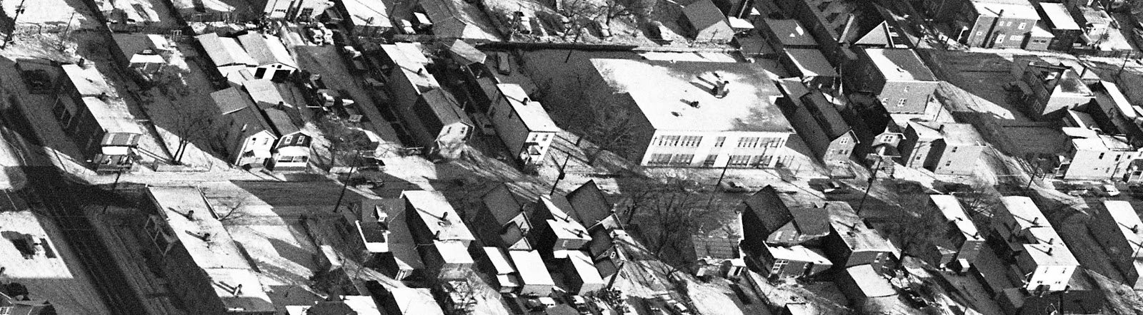
1963 view of Forward Avenue looking east, including
the Notre Dame des Anges school in the middle.
(cropped from Ottawa Archives photo CA-8697)

The building later operated as a Montessori School in the mid-1970s, and the Ottawa School of Art from about 1978 until late summer 1983.

April 19, 1975

December 29, 1979

Ironically it was exactly 100 years after becoming Catholic property that the Separate Board sold it. The Regional Municipality of Ottawa Carleton purchased the building for $381,000 in February of 1985. Moffatt Construction handled the job of converting the school into housing units. The job was completed by the end of August 1985, and the RMOC operated the building as 17 emergency shelter units for homeless families (women and children fleeing family violence, victims of fires and floods, those evicted from their homes, or newcomers to Canada with nowhere else to go). In 1990, the building was expanded with the addition of a third floor, allowing for 25 units total, which resulted in the closure of the underutilized Waller Street shelter. This shelter continues to operate today, with more a focus on women and immigrants/refugees.

Miscellaneous Stories from the Early Days

Smallpox hit Mechanicsville, and especially Forward Avenue in the fall of 1901, when two children of the Cusson family and three children of the Saumur family came down with smallpox. At the same time, a child of Francis Meunier of Hinchey Avenue died from it, while there were many other cases throughout the village. The smallpox outbreak was significant in 1901 in greater Ottawa, and patients were treated at the isolation "hospital" on Porter's Island, which was a small wood shack and a series of outdoor tents.

One of Mechanicsville's earliest residents was Hyacinthe Latreille, who operated a grocery shop and small hotel and tavern on Hinchey Avenue in the 1890s at the north end when Hinchey used to extend to Emmerson. The family later moved on to Forward around 1901, and there the Latreilles would remain for nearly 100 years, into the 1980s.

March 7, 1910

The first house to be bricked was Alexander Dennault's house at 160 Forward Avenue, which was built between 1899-1901, and bricked upon completion. This house had survived until the 1990s. Dennault was a yard master for the CPR (he also had owned for many years the duplex house next store at 154-156 which he had acquired from James Newton in 1886).

The typhoid problems of Ottawa, but particularly the neighbourhood, of the pre-WWI era are well documented (here is a bit I wrote on Cave Creek last year: https://kitchissippi.com/2016/03/30/cave-creek-ottawa/), and in December of 1913, the Nordenfelt family was significantly affected. The father Oscar was an immigrant from Sweden, the couple marrying in 1897 and having recently moved to Mechanicsville from Dundas, Ontario.

Ottawa Journal - December 22, 1913

The advertisement below from 1918 lists two houses on Forward Avenue for rent. 142 Forward could be rented for $5 per month, while 116 Forward  could be had for $7 per month!

April 3, 1918

The last block of Forward Avenue to have concrete sidewalks installed was the southern block, from the CPR tracks to Lyndale. These sidewalks were included in the city's local improvements work orders in late 1923 or early 1924.

Into the 1930s, it was still common for Mechanicsville residents to keep animals on their property. The photo below was taken at 93 Forward Avenue in approx. 1928.

Ronald Blais at 93 Forward, circa 1928.
(Source: Facebook posted by
Aline Ullett, March 2015)

From the late 1800s until as late as December of 1970, fire alarm boxes were a feature of all neighbourhoods in Ottawa. They originally were required in the days before telephones were commonplace in all homes. A person would open a small door, pull a lever and then turn a knob or pull a hook. A spring-loaded wheel would then activate, tapping out a pulsed electrical signal corresponding to the box's number to the fire department headquarters, who would then send out wagons to that box. One of Mechanicsville's two fire boxes was located at the south-west corner of Forward and Burnside (just outside of the River View Hotel).

Below is an early, clear aerial photograph of Forward Avenue from 1933. showing the north end of the street. Parkdale Avenue is at the top, with Emmerson at right and Burnside at the left. Only two houses from this entire photo still exist today (82 and 84 Forward).

Aerial photo from May 5, 1933 showing the north end of
Forward Avenue and Parkdale

The 1930s and Onwards on Forward Avenue

Fires were an issue for all of Mechanicsville. There was about one per month throughout the 1800s and first half of the 1900s. Numerous reports through the years show Forward Avenue had its share of house fires, understandable due to the wood construction of houses, the poor quality of the build, the shoddy electrical installations, wood fireplaces, heating pipes, etc, The close clustering of the houses could turn a small house fire into a burning block. Forward had many fires over the years, but one notable one with sad fatalities.

In the early hours of May 2nd, 1938, a fire struck the home of Nelson Lacasse, former alderman of Elmdale ward, at 71 Lyndale, at the north-east corner of Forward. Sadly, two of his grandchildren, Jeannine Lacasse (aged two years) and Alice (three months) died in the fire. Overheated stove pipes were given as the cause of the fire, which broke out in the bedroom above the kitchen, where Nelson's son Rene and the two children were sleeping. By the time Rene work up, the room was engulfed in flames, and he was unable to reach his daughters. Both he and his father suffered serious burns attempting to reach the children, as did three firefighters as well. Rene's mother and three sisters survived the fire, as did a 17-year old brother who had left for work earlier. Rene Lacasse had lost his job six months earlier and the family had been forced to move in to his father's home.

Making the story even more sad, Rene's wife Lucille was in the hospital at the time of the fire, in critical condition owing to a serious illness from which she was not expected to survive. She had major surgery scheduled the day of the fire. To the surprise of many, Lucille's condition improved, to the point where she was able to go home a week later. The family was not able to tell her of the death of her two children for several days, and she missed the tragic funeral held the day after the fire at St. Francois D'Assise Church.

As was the case with most fires, even though the home was heavily damaged by the fire, the interior was rebuilt, and the home still stands today. The fire led to the City conducting stricter inspections of stove-heated homes, to ensure the pipes were protected, and located a safe distance from the walls. The Fire Chief noted in the Lacasse fire that the pipes passed closely to the wood partition, which was also coated with several layers of wallpaper, loose in parts, which contributed to the rapid spread of the fire.

***

As with most streets in Ottawa, Forward Avenue was not without their heroes in WWII. A few of the residents noted in records as having enlisted in the war effort include Sgt. Edmond Labrecque of 137 Forward:

June 15, 1944

Others noted as having participated in the war were Sgt. A.J.M. Landry of 167 Forward, Cpl. G R. Jodoin of 2 Forward, CSM H.F. Sullivan of 128 Forward, Pte. H. O'Connor of 1 Forward, Pte. J. O. Bourguignon of 106 Forward, Sgt. R. E. Auger of 179 Forward, Pte. H. D. Stewart of 82 1/2 Forward, L. Cpl. W. Lepage of 100 Forward, and L. Cpl. R. D. M. Donovan of 114 1/2 Forward. And this list is probably not even complete.

On Canada Day, 1946, Reginald Gourgon, 36, of 125 Parkdale Avenue was killed at the corner of Burnside and Forward when he grabbed a live electrical wire which had been brought down by the branch of a tree which had broken off during a major 70-mile-an-hour storm that hit Ottawa. Gourgon had been walking along Forward after the worst of the storm, and noticed the wire on the sidewalk. Though a large group of men were close-by keeping children from approaching the wire, Gourgon suddenly attempted to move it off the sidewalk onto the road, and the wire, containing 2,200 volts instantly electrocuted him. He fell to the ground, his right hand still holding the wire. Albert Aspeck of 128 Forward forced the wire from his hand with a large rock. The fire alarm box located right next to the incident was pulled, and three stations replied immediately, but of course, nothing could be done for Gourgon.

The photo below is taken on Forward Avenue in 1952, though I can't quite tell where exactly it was taken.

Forward Avenue, 1952
(Courtesy of Maureen Mathurin-Kempster)

On June 29th, 1953, a fire hit 160 and 162 Forward Avenue, luckily with no injuries or fatalities, despite the enormous number of people occupying the two houses at the time! Defective wiring was given as the cause of the fire which broke out at the back of the two-storey home at 160 owned by Andrew J. Findlay, which tore through the wooden sheds at the back, and then jumped the laneway and gutted 162 Forward, owned by Alfred Tremblay. Mrs. Findlay was having dinner at 160 with her brother and her four children when the tenant who lived upstairs at 160 shouted down about the fire. Mrs. Findlay also had five infants in the downstairs bedroom (home daycare) and rescued them out two at a time, handing them to neighbours. Meanwhile, Mr. Tremblay and his wife and six children all escaped uninjured as well.

A major fire hit Forward Avenue on Sunday May 20th, 1956, when children playing with firecrackers burned down one of the old ice houses/warehouses at the south end of Forward, and caused damage to 18 houses on Forward and Hinchey. It was a blaze that actually threatened Mechanicsville as a whole. 191 Forward was fully lost to the fire. (I'll be covering this fire as an article of its own in an upcoming blog post soon).

In early 1963, some area residents were pushing for Forward Avenue to be opened up over the CPR tracks, as it was known that the end of rail traffic was coming (it had already been announced that passenger trains would be removed soon). But the Board of Control refused their request. Mayor Charlotte Whitton commented that it would cost $16,000 to create the access over the tracks. On top of that, there was still freight traffic planned to continue, which it did well into the 1970s. Had council agreed to establish the opening in 1963, it likely would be open at Scott Street today!

Here are a few photos from the mid-1960s:

1963 view of  the north end of Forward Avenue, looking
west, with Parkdale at the top.
(cropped from Ottawa Archives photo CA-8697)

1965 view of Forward looking east
(cropped from CA-9085)

The north-west corner of  Forward at Burnside, showing the
long house at 114 Forward which by then featured six
apartment units. Photo taken March 11th, 1965
(Source: City of Ottawa Archives, CA-24796)

The long-time Chenier family home, at 194 Forward, circa 1956.
(Source: City of Ottawa Archives, CA-25254)

How did I get this far and not mention the Joanisse family of Forward Avenue? The Joanisse family first arrived on Forward in 1885, and eventually at least four brothers (out of a family of 13 kids) and their families would reside long-term on the street. John (Jean Baptiste Jr.) Joanisse built 44 Emerson in 1885, and resided there raising his 12 children (according to a tree found online) until his death in 1940. He worked as a "riverman" for lumber baron J.R. Booth. Younger brother William built 88 Forward around 1890 and resided there until his death in 1930. Moise and Clara Joanisse built 172 Forward Avenue and Francis and Rose Joanisse built 170 Forward next door in late 1900 or early 1901. Moise was a mill labourer, and later worked with the City of Ottawa. He remained at 172 until his death in 1953, and at the time of his death he had 21 grandchildren and 36 great-grandchildren. Meanwhile his brother Francis who built next door was also employed as a riverman, and had no children. The photo below is of Moise's house:

172 Forward Avenue, the long-time home of Moise and Clara
Joanisse. Photo from May 3rd, 1965
(Source: City of Ottawa Archives, CA-25255)

Construction on the Ottawa River Parkway east of Parkdale began in May of 1966, and was completed in time for the opening in July of 1967. The Parkway severed Forward Avenue's direct access to the Ottawa River, and as mentioned above, was the cause of significant expropriation at the north end of the street.

In 1971, a storm sewer outlet was contracted for an outlet from Forward at Emmerson, out to the Ottawa River, 461 linear feet of 84 inch diameter tunnel. This was called the "Hintonburg Central Outlet".

In July of 1973, the press began covering the saga of the boarded up houses on Forward and Hinchey north of Burnside. 14 houses had sat vacant for several months after they had been acquired by Toronto-based real estate developer Deltan Realty Co. The company purchased the houses and immediately ordered all residents to move out by May, as the company had planned to build apartment buildings (originally planned were homes for the elderly). The houses sat vacant, with no fencing around the properties. As a result, most homes were broken into by "groups of teenagers who have been exploring the houses", leaving most doors and windows broken and open. The other problem was that it was reported by the papers that "the area became infested with rats, and that people are using the buildings for trash dumps." Oddly, the hydro and water continued to operate in the homes, leading residents to worry about fire, or children playing in the houses to be burned, or cut by the glass. Roland Boucher who lived across the street at 82 Forward led the residents fight for the site to be cleaned up and fenced off. One photo appeared in the Journal in July:


July 20, 1973 photo of one of the houses, showing the
destruction and garbage that had occurred.

From 1973 onwards, there were two types of history happening on Forward Avenue. One was the demolition of houses and construction of new buildings. I don't have the exact dates/details of all the buildings that were built on the street unfortunately, and it would not be too easy to research. The second type of history were stories of crime. Mechanicsville in the 70s and 80s went through probably its darkest period, and there were many stories of break-ins, thefts and even murder on the street. Not too much positive or all that interesting to report on, I'm afraid.

One story of note was of the big fire on February 12th, 2007, which hit the Place Allard townhouse complex at 187 Forward,

2007 fire on Forward Avenue
(Source: Ottawa Fire Services)

2007 fire on Forward Avenue
(Source: Ottawa Fire Services)

The five-alarm blaze injured six fireman, three seriously, who had to jump from the third storey when the smoke and heat became overpowering while searching for trapped residents. The firemen survived thankfully, but 14 public housing units were destroyed, leaving 35 homeless, and causing an estimated $500,000 in damages. The fire exposed some major issues within Ottawa Fire Services, and led to significant changes to how Ottawa firefighters responded to fires. As the Citizen reported: "Much went wrong that day. Communications systems broke down. Critical transmissions were missed. Equipment malfunctioned or was mishandled. The system designed to account for the whereabouts of firefighters failed. And in the heat of rapidly unfolding events, some firefighters lost "situational awareness": the ability to make informed, rapid decisions." A 100-page report was produced of the near-tragedy, and changes to the OFS included all firefighters equipped with a portable radio, a new strategies and tactics manual, new search methodology, new ladders, fire dynamics program re-developed to teach firefighters more about the science of a fire, new thermal imaging cameras, and new self-contained breathing units, among other changes.

Meanwhile Place Allard (which was named for Joseph D. Allard, long-time Alderman and Wellington Street merchant in honour of his life-long dedication to the residents of Mechanicsville and Hintonburg) was rebuilt, and had an opening celebration just this past June.

Oddball & Interesting stories and articles

Here is a handful of old miscellaneous newspaper articles about people and places from Forward Avenue that I find interesting, and tell a bit more of the authentic stories from eras of long ago:

From the Ottawa Journal, September 8, 1899, an ad for lost
horses. Goulet resided for many years at 82 Forward

From September 23, 1905. About half-way through, the
story begins about some trouble on "Fourth Street" (aka
Forward Avenue)

June 30, 1927

November 8, 1932

January 10, 1933

May 11, 1935

August 4, 1948

August 23, 1955

Also August 23, 1955

So there you have it, the exhaustive, but by no means complete history of Forward Avenue. So many stories and happenings over its 144 years of existence, I hope you found some of these highlights interesting to read! It's too bad Forward Avenue really has lost so many of its original houses, but at least the stories and memories will never be lost!