Wednesday, March 4, 2015

Remembering Ottawa's smallest park: Grange Park

When I was a kid growing up on Gilchrist Avenue, there was a small park a few blocks over which my Dad would take my brother and I to. It was a pretty boring park: there was a sandbox, a few swings and a little mysterious hut. The fence was old and rusty, the grass didn't really ever grow, and there were foundations, or some kind of remnants of something exciting that maybe *used* to be there (but certainly wasn't anymore). My Dad had good memories of the park too (having himself grown up on Western Avenue), but by the mid-late 80s, it was minimally tended to, long forgotten in lieu of the larger and more modern parks in the area.

Long-time (or former) residents of Wellington Village may remember Grange Park in it's heyday. Perhaps you have good memories of parties or events at the park, when it would have been a central spot for the kids of Wellington Village to play in the 1940s and 50s. By the mid-90s it was officially abandoned, and now a new and modern house stands in its place. 

It was the fall of 1945 when the alderman for the area (then known as Victoria Ward) Thomas F. Ellis, who was a strong proponent of parks and recreation, suggested that the vacant lot at the southwest corner of Grange Avenue and Scott Street be considered as park space. Ellis was in his first year in his role as alderman, and was active in improving the district. The city had acquired lot 777 on Grange Avenue (along with many others) through foreclosure due to unpaid taxes. The lot had sat empty, as most of the north ends of the streets between Western and Holland had at the time. Construction on most streets had started at the Wellington Street end in the late 20s, and once the depression era hit, largely did not grow much north past Spencer Street. Lots that had been purchased by home-building dreamers and land investors were surrendered to the City due to an accumulation of taxes owing on what had become almost worthless land. Scott Street did not even exist in actuality at the time; at best it was a dusty lane that local residents might use to sneak to the next street over. The CPR train tracks separated Wellington Village from the desolate lands that would one day become Tunney's Pasture, but it was really a vast empty spot. 

1933 aerial photo. That is the north ends of Ross, Grange, and
Smirle. Scott Street is the dusty/muddy lane running left to
right, while above it are the CP rail tracks.
The area perked up around 1940 (surprising, considering WWII was raging at the time), and began to fill in towards Scott Street (which itself would not be paved until 1953!). Grange did not have any houses on the west side north of #38 until the early 40s, but houses began to be arrive as builders purchased these lots for as low as $50 from the City (who were keen to see the lots evolve as quickly as possible into tax money-generating properties with houses). Since the city still owned lot 777, Alderman Ellis suggested it as a possible spot for a park. He may have felt the lot was perhaps unsellable, and could not be built on, as it had an odd, triangular shape. But since it had a corner lot location, he perhaps saw that it could be a fair central spot for parkspace, despite its tiny size.

Ottawa Journal - March 26, 1946

In March of 1946, the announcement in the local papers made it official: Grange Park would open that summer, complete with a wading pool and some playground equipment.

Work began in late May of 1946 on two new wading pools in Ottawa, at Grange Park and at Laroche Park on Bayview.

By August of 1946, the park was in full community swing, and several newspaper articles covered some theme days held at the park. 

Ottawa Journal - August 27, 1946

Ottawa Journal - August 31, 1946

The Ottawa Playgrounds Department (as it was actually known) was responsible for the establishment of these "miniature playgrounds", of which they opened several during the era. Grange Park was considered the first of these "ultra modern playgrounds", where the City would construct the parks, and install required equipment, but the management and care of them were left to the "mothers and children of the neighborhood". The committee promoted that for the long-term benefit of the park, "the small price they would now have to pay for their children's safety was the little bit of care they would have to exercise in seeing that the playground's facilities were kept in good shape.".

Chinese Elms were planted in the Park in the early 1950s to add to its charm. An article in 1947 mentioned a planned "field house" to be built, and another from 1949 mentioned a planned "comfort station". Certainly something was built at this time, though it was quite small, basically a little hut, which I'd hesitate to call either a field house or comfort station.

Annual events were held between 1946 and the late 1950s. There were popular pet shows, doll shows, tin can derbies, even a "Miss Grange Park" event each year. The end of year party was the most well-attended. I could not believe reading that in 1948, the end of season party (called the "Closing" party), had 600 people attend. They must have been standing on each others shoulders 4-5 people tall to fit that many people into that space!

Ottawa Journal - September 2, 1948
Ottawa Journal, August 2, 1952
Ottawa Journal - August 20, 1953

Below is an aerial shot of the park from 1965 (the best I could come up with from the glory days of the park - if anyone has any vintage photos taken at the park, I would absolutely love to see them - and scan one or two!). The wading pool (or pools?) are visible as white-bordered squares, with the little square hut between them (see the photo below for detail on it).

1965 aerial photo

It was sometime around the late 50s or early 60s when it seems the park's popularity died off. There was no mention of events at Grange Park in the papers after 1960, though the Citizen in 1970 did joke about the existence of "postage stamp-sized Grange Park, a one-tenth-acre lot complete with wading pool and swings."


Grange Park how I remember it - from June of 1991.
This is the little "fieldhouse", which was always locked,
and the bizarre table top, which I believe would have
covered the pump and works related to the wading pool?
(City Archives CA-24331)

In 1996, the City of Ottawa declared the property surplus, and though it took a few years, was sold to a private individual. A zoning change was required, and was reviewed and approved by the Planning and Environment Committee in 2006. The West Wellington Community Association lamented that they had made efforts through the local councillor to save the park for neighbourhood use, in particular as a community garden to be maintained by local residents (which would have been a fantastic idea), but they received little help in this quest, and ultimately, the City sold and rezoned the property. The neighbour across the street, who was also a member of the Ottawa Forests & Greenspace Advisory Committee, made sure as part of the zoning application that the large tree was protected during the process (it was, though it had a huge "X" on it as of this summer, like so many trees in our area). 

The abandoned park in 2002  - even the sandbox and swings are gone.

The new house at 22 Grange Avenue was constructed between 2006-2007, and to the surprise I'm sure of many in the community, a fairly large home fit well into the relatively thin lot. Not to mention, it fit in to the Grange Avenue streetscape quite well also.

2007 aerial view, following construction of 22 Grange Avenue
The fence around 22 Grange Avenue which is still there today.
The original swinging opening still visible on the Scott Street side.
So there you have it - the history of the forgotten Grange Park. Part of the memories of many Wellington Village residents, the product of an era of City planning that prioritized outdoor play in local neighbourhoods. We got away from that for a while, but the pendulum seems to have swung back the other way on this, as small community parks seem to be popping up more regularly now, and that can only be considered a good thing.

----

Since I wrote this post, I have come across a vintage photo taken in the park. Courtesy of the amazing photographic collection of Bruce Chapman, here is a photo from May of 1947, looking east from the park (you can see the short stone hut that is visible in the 1991 photo shown above).


Monday, March 2, 2015

Street Profiles: The History of Belford Crescent

Today I am taking a quick look at a fairly small street in Kitchissippi, but one with a somewhat interesting history nonetheless. I was inspired to take a second look at this street after a question from a blog reader regarding access to Tweedsmuir off Belford. As I had done a house history on Belford a few years ago, I dusted off my old research, and recalled that there are a few little stories of interest attached to this small, hidden crescent in the Kirkwood/Iona area.


Belford Crescent on a current map
Current Street Name: Belford Crescent
Former Street Name: Belford Street and Bruce Street (what is now Belford Crescent was originally two separate streets).
First established: 1944
Name meaning: Unfortunately I have never been able to confirm exactly who it was named for, but it was most likely named to honour one of, if not both of two brothers who were prominent citizens in Ottawa, Charles A. Belford and John A. Belford. Charles was only 11 years old when he became a page in the House of Commons. He developed a bond with Sir John A. MacDonald; in fact, when Sir John A. passed away in 1891, Charles carried the mace at his funeral. He would go on to a 40-year career with the Canadian Atlantic, Grand Trunk and Canadian National Railways, where he became one of the world's top experts on transportation systems. The Journal noted at his retirement that "offhand he can quote mileages in all sorts of out-of-the-way places in Europe, Asia or Africa". During WWII he was transit controller for the Ottawa and district area under the Department of Munitions and Supply. His brother John was a lumberman, who later became director of the Central Canada Exhibition, and was very much involved in the political and social scene of Ottawa.
How named: By the developer, Carleton Realty, who selected the names of the streets created by their new subdivisions in the early 1940s.

Early days:
The Heney family had acquired the north half of lot 32 of Nepean Township (the area between the back property lines on the east side of Hilson, west to the back property lines behind the east side of Tweedsmuir, and north of Iona Street - which was the dividing line between the north and south halves of the lot) in 1854. John "Buffalo" Heney purchased this property and opened a farm on the land. One of Ottawa's oldest buildings still exists on the Richmond Road, the stone "Aylen-Heney House" at 150 Richmond Road near the corner of Kirkwood. In 1892, the elderly Heney transferred ownership of the property to his son Frederick A. Heney, and soon after passed away in 1896. The elder Heney was involved in many business affairs, and so it is difficult to pinpoint exactly when the family's farming business ceased, but it was likely sometime around the 1880s to early 1890s. In 1899, after studying law in Toronto at Osgoode Hall, Frederick A. Heney returned to Ottawa and built an incredible 18-room mansion on the site of what is now the Canadian Bank Note Company. Fred would go on to become one of the Township's largest land owners, and was reeve of the Township from 1898 to 1911. His business interests were vast, and would take paragraphs to cover.

In 1899, Plan 186 was filed with Carleton County, dividing parts of lot 32 into blocks. This was a plan splitting part of both the Heney property and the Holland property in the south half of lot 32. It even created three new streets: Hilson Avenue (named after George Holland's wife Alison Hilson Holland) which still exists today, Heney Avenue (now Kirkwood), and Bower Avenue (now Bevan). Block J would contain the future Belford Crescent, but for now it was empty farmland.


Carleton County Plan 186


Aerial photo from 1920 - that's the streetcar line (Byron) at the top, Iona near
the bottom, Tweedsmuir along the left and Hilson along the right. Wesley is
not yet joined (where it looks like it should join appears to be the ruins of the
original Hayes homestead, which had been occupied until the late 1890s).
The future Belford Crescent spot is vacant space. (Note the huge smudge in
the center of the photo is damage to the original negative unfortunately).


Aerial photo from 1928 of the same spot. Most streets have now
been paved, and the Hayes house is gone for sure. Belford still
just an empty field.

Portions of the farm were sold off over time, including to the R.L. Crain Company, but by the 1940s, John Heney still owned several pockets of land south of Byron Avenue.

Development:

On May 27th, 1944, Heney sold to Carleton Realty the remainder of Blocks I and J from the old farm property, for the sale price of $7,000.

Carleton Realty was one of, if not the first large developer firms in Ottawa. In the Westboro, Laurentian View and Island Park Drive areas, including right here on the former Heney farm, they created Ottawa's first true subdivision housing project. During the latter stages of WWII, the federal government began to open up funds via the National Housing Act, to ensure that housing would be available for veterans upon their return. After WWI, the Canadian government had been ill-prepared for the return of soldiers who had been away. These young members of Canada's forces had come home to few jobs, and little to no available housing. It was a disaster for Canada, and the government made it a priority to ensure the same thing did not happen after WWII.

Carleton Realty was created by a triumvirate of top contractors in Ottawa: Frank Shouldice, Ken Green and C.A. Johannsen with this very purpose in mind. With the funding available from the Canadian government, the group assembled plans for subdivisions in the west end (and also initially in Eastview), and in 1943 began constructing homes of a smaller size, with similar floor plans and layouts, though still having somewhat unique features. Some Westboro residents at the time were not happy about these plans, and worried that the community was being filled with homes that would cheapen the appearance of the established neighbourhood, and perhaps even sit vacant and unwanted. This of course proved to be untrue, as indeed the homes proved quite popular, and though we are seeing them being replaced in the new century for larger homes and the dreaded semi-detached doubles, they did serve the area well for many years, and overall the initiative was a success for Carleton Realty. Not only did they build quality homes at a profit to themselves, but they also quickly turned the sparsely populated area of central Kitchissippi into a well-filled and popular neighbourhood, and most importantly, they helped ensure that ample housing was available for the thousands of soldiers returning home in 1945-1946.

Carleton Realty full page ad in the Ottawa Citizen

Another Carleton Realty full page ad in the Citizen, 1944

Plan 448 (a twin of Plan 443) which
first created Belford Street.
A few months after purchasing Blocks I and J from Heney, on September 27th, 1944, Carleton Realty filed Plan 443 with Carleton County, which subdivided Block I (east of Bevan) and Block J (west of Bevan). Block J was split into 8 smaller lots, each about an acre in size, while Block I had two large lots, plus a handful of smaller, more standard residential lots. The plan most importantly, created new streets Bevan (renamed from Bower), Dawson, Belford, and Bruce.

It is important to note here that what is now Belford Crescent was actually two separate streets on the original 1944 plan: "Belford Street" and "Bruce Street". Even though the street actually did function as a crescent, the streets would remain named this way for another 23 years, until the crescent was formally established.

The bizarre initial design of Carleton Realty's subdivision was modified in the spring of 1945, when the company filed a new Plan 448 (seen at left), replacing Plan 443. The new plan broke up the larger 1-acre parcels into more regular, typical builder lots, mostly around the 50x100 size.

In May of 1945, the Township of Nepean published their "Local Improvement Notices" listing all the municipal work to be done in the summer of 1945. Included in that list were the construction of sewers on Belford (at a cost of $1,292) and on Bruce ($1,444), as well as the the construction of water mains on Belford ($1,445) and Bruce ($1,573). This work would have been complete by the fall of 1945.

In 1945, Carleton Realty began building homes and selling lots from plan 443. An article in the Ottawa Citizen on May 23rd, 1945 indicated that the Carleton Realty Company had begun construction of 85 new homes in “Heney Park West”, with already 32 of the homes sold. Homes were sold from $5,100 and up, purchasable for as little as $500 to $1,000 down, and all homes featured “concrete foundations, furnaces with hot and cold air ducts, built-in baths, solid masonry walls, insulated walls and ceilings, hardwood floors, and good plaster interior finish with asphalt roofing color to suit owner.” The vast majority of homes built in this community were built by Carleton Realty itself, though some lots were sold to individual buyers, and the house built privately.

The first to buy on what is now Belford Crescent was Burton and Hertha Darlington, a young couple who had married just five years prior. They purchased lot 39 on Bruce Street in mid-1945, and soon after construction began on the first house on the street, which is now 257 Belford Crescent.


257 Belford in present-day - it was renovated and expanded
significantly during the 1990s
Sadly, on February 12th, 1946, long-time land owner Frederick Heney passed away at age 76 following a lengthy illness. He passed away just short of seeing the farm property, which had now been in his family for over 100 years, really begin to develop. If he had lived even two more years, he would have seen quite the striking change. Less than a year after his passing, his amazing large mansion, even at the time called one of Ottawa’s top showplaces, was torn down to make way for the new Canadian Bank Note Company building. (I'll definitely have an article dedicated to the Heney mansion soon - complete with some great photos that will surprise you, and make you despise the Bank Note building).

So by early 1946, there were two completed homes on Bruce Street: the Darlington home at what is now #257 Belford (but then was 214 Bruce Street); and Lloyd and Florence Horricks had a home built on lot 36, which is now #243 Belford (then 232 Bruce Street). The Horricks didn't remain on the street for too long, and the only newspaper hit I could find for them during their brief stay was an amusing note in the newspaper in 1948 about a loose dog charge (see below). The news media in Ottawa even after WWII, still had somewhat of a small-town feel to it.


Ottawa Journal, May 20, 1948

There were also two houses under construction at this point: Frederick and Adelaide Rowland's home on lot 38 (218 Bruce, now 253 Belford Crescent) was nearly completed in May of 1946, while the foundation was just in on Charles F. Russell's home on lot 49 (231 Bruce, now 242 Belford Crescent).

In April of 1946, the first building permit on the Belford Street segment of the crescent had been taken out on lot #50 (the future #232 Belford), though the house actually would not be built for several years.

Two other permits were also taken out in April on Belford, and these homes were completed by late 1946. They were on lot 53 (214 Belford Crescent) first owned by Robert J. Burgess, a reporter with the Ottawa Journal newspaper, and his wife Winnifred; and on lot 58 (213 Belford), first owned by James C. Mackersie, a boiler inspector with the General Accident Assurance Company of Canada. These permits were mentioned in the monthly listing of building permits that the newspapers of the era would print:

Ottawa Journal - May 8, 1946

The story of the Carleton Realty Company actually has a bad ending. The firm went out of business in 1947. The Ottawa Citizen reported on June 1st, 1947, that the Carleton Realty was putting in an application for bankruptcy and that most concerning were the veteran homes that Carleton Realty had begun construction on. They had started a project in 1946 to build 200 low-cost homes for veterans “principally of the bungalow and two-storey type and mainly in the Heney Park area of Laurentian View In the majority of individual cases, the war veterans had financed the building and purchase of houses through re-establishment credits, gratuities and loans of the Central Mortgage and Housing Corp. The original contract prices for the homes ranged from $6,000 to $7,000 it was reported, and many veterans had used all available resources for construction costs. These ex-servicemen were said to be in financial difficulty with the prospect of losing their homes unless some organized assistance is provided following the assignment of the building company.” Later in June it was reported that 104 claims had been made against the Carleton Realty Company, with a former executive stating that the bankruptcy had occurred due to a “shortage of labour, materials and increased costs.” Following the bankruptcy fall-out, it was reported that many soldiers were still in dire risk of losing their unfinished homes, as they were potentially years away from being able to afford to finish the construction on their homes. For those with finished homes, liens had been placed against the homes by the companies who had done portions of the work, and the owners were left to deal with these debts. A very unfortunate ending to what initially promised to be a positive endeavour. The principal directors of the company (Greene, Shouldice and Johannsen) would still find great success in the contracting business in Ottawa following Carleton Realty's demise; in the end a small blip on the great careers each of these men had.

1948 Fire Insurance Plan showing the build-up of Belford and Bruce Streets
over just a short period of time.
(Pink indicates brick veneer, yellow indicates wood frame).

Above is a look at the development of the area by 1948. To specifically address the question asked by the commenter to my "History of Tweedsmuir Avenue" article, it does appear that possibly for some of the residents of Tweedsmuir that they would have been able to take advantage of the crescent to have garage access off Belford. The Fire Plan above definitely shows that at least the one house had a garage that could have received a car from Belford. But this would only have been after the street was opened up in 1944-1945.

Below is an aerial photo from 1965 showing the built-up street, and it appears that garage from 1948 was gone by this point anyways.

1965 aerial photo of Belford Crescent

On December 12th, 1967, at 2:30 p.m. at the Nicholas Street Court House, the Corporation of the City of Ottawa presented a proposed by-law to Judge Peter Joseph Macdonald, recommending that Belford Avenue and Bruce Street be officially linked to form one single street, to be called Belford Crescent. This was based on the recommendation of the Street Names Advisory Committee of the Ottawa Planning Area Board, made to the City Clerk in August of 1967. The proposal was accepted, and the change came into effect on January 1st, 1968.

This article would not be complete without mentioning some of the long-time residents of Belford Crescent, in particular Clifford and Frances Young, seemingly the last of the "originals" who resided at 231 Belford from its construction in 1949 until just recently (while researching this article, a google search revealed that Mrs. Frances Young just passed away this past fall at the age of 97). Also residing long-term: Eric and Frances Chipper lived at 252 Belford (formerly 219 Bruce) from it's construction in around 1947 until a few years ago; Arthur and Eileen Abson resided in 239 Belford (formerly 234 Bruce) from 1948 until the late 80s; and Archibald and Muriel Delaney, who built 220 Belford in 1947, and remained there until 1979 at 220. (My apologies to any other long-time residents I may have left off the list, I did my best with the lists I had, without doing individual house histories).

Sunday, February 22, 2015

The evolution of Whispers: Westboro's Friendliest Pub - and one of it's oldest buildings!

A pub like Whispers is exactly what makes Westboro so great. While I'm not a big drinker, I can't appreciate enough that a place like Whispers has been able to survive for so long. It's a place where anyone in Westboro can go and enjoy whatever kind of evening they like. You can hear a live musical act, watch a game, or play trivia; you can bring a large group or party in and have a loud evening, or you can have a quiet chat next to a fireplace. The reason it probably has been able to survive all this time is that it is not pretentious in any way. And it appeals to the wide clientele base that now inhibits Westboro. You can be a sweaty sports team after a summer ball game or a late winter evening's hockey match; they'll be glad to have you. You can be a businessperson bringing a client for a working lunch, they'll be glad to have you. You can be in your teens, or in your senior years, and there is a bar chair or table ready for you any time you like it. The patio is great too, if you can find a spot. The staff is always incredibly nice too, and will be as hand-on (or hands-off) to suit whatever you like. The atmosphere is laid back, and they don't try too hard. To me, its a perfect pub, and I'd be devastated if I ever heard it would be closing. A few years ago they even improved the decor by adding a lot of historical artifacts and old photos of a local interest. So really, what more could you ask for?

It was natural then, that I set out to cover the history of the pub. I've been going through those front doors practically my entire life. Through family dinners, hockey team celebrations, hockey pool draft nights, dates, and eveningss where its just somewhere comfortable to go, Whispers is easily one of my favorite spots to be, And again, not that I'm that much of a barfly, but I've been in there enough times to know the layout of the place like the back of my hand - where every photo is and what its of. But as a history-curious guy, I've always wanted to explore the history of the building more. My interest was picqued years ago when I noticed that, hey, wait a minute, if you look at it from the street, it clearly used to be a house. They when you think about the interior, well sure, you can imagine it being a house! When they opened up the second floor a couple of years ago, you almost felt like you were heading up to the bedrooms!

So with this blog, I now have a completely valid excuse to really delve into the the past, and find out the whole back story of the pub. I knew bits and pieces already, but it was really worth digging deep in to records at the land registry office and the city archives.

To start off, Westboro itself started life essentially as a small village supporting the local mill located by where Westboro Beach now exists. The village was even named "Skead's Mill", after its owner. After the mill closed (and later burned) in the 1880s it took a while for the area to grow. Thanks to the arrival of the trains, and in particular the streetcar line to Britannia, Westboro became a desirable location for Ottawans to live and commute. Once the automobile arrived, there was no looking back.

By 1910 the Westboro population was just around the 1,000 mark, and many of the former farmers were finding that they could sell their property for many times what it was worth only twenty years prior. Some took it upon themselves and created subdivisions of their own. Others sold it off in blocks, and real estate prospectors bought up land as investments. F.X. Ladouceur was one such prospector, and I detailed his 1909 "Mansfield Park" plan in the history of Tweedsmuir Avenue article.

Scan of the first page of the original
sale deed for lot 6, Richmond Road.
The southern edge of that plan was Richmond Road, and those naturally were the most sought-after lots when they hit the market. On November 7th, 1910, Laderoute sold lot 6 at the corner of Richmond Road and Xavier Avenue (now Tweedsmuir) to Mary Margaret Larkin for $600. Mary was the wife of carpenter William Larkin (it was common in the era for real estate transactions to be put under the wife's name). The Larkins, who resided downtown at 112 Percy Street, financed the purchase with a mortgage of $650, which likely just covered the purchase and perhaps some immediate foundation work at best.

In February of 1911, a second, larger mortgage was taken out from a Mrs. Marie Davieau for $1,050, for the construction of the house.

The two-storey, wood-frame house was completed quickly. The Nepean Township assessor visited on April 21st and noted that the family was occupying the home. They had also made it just in time for the 1911 Census of Canada, which was taken on June 1st.

The value of the property, including the new house, was assessed at just $500 in April of 1911. Click below to see a scan from the original assessor's rollbook, listing the newly built home on lot 6:

1911 Nepean Township Assessment Roll showing the Larkins at the newly
completed home on Richmond Road. William listed as 42 years old, F (freeholder),
lot "6 N Richmond Rd in E 1/2 lot 31", Concession "1", $200 value of the land,
$500 value for the building, total $700, school section 2, "P" (public school),
"2" (children 5-21), "2" (children 5-16), "6" members of the family, "1" male
21-60 years old, and "Apr 21" being the date of the assessor's visit.

Mary & William Larkin
Photo at left of Mary and William Larkin, the builders and first occupants of the future Whispers pub. William Larkin was also responsible for the construction of several brick homes in the Westboro area as well, according to his grandchildren.

Signalling that work was progressing on the house, the value had increased to $600 in 1912, and then once it was bricked in 1914, had increased all the way up to $1,800.
1915 Fire Insurance Plan showing the
structure of the Larkin house.
Construction costs had added up, and so by 1915 the Larkins took out a new mortgage for $2,500 from a David McCaffrey (it was very common in these era to acquire a mortgage from an individual lenders, not necessarily  the bank). Within a year the mortgage was re-assigned by McCaffrey to John F. and Bessie Dowling. This would later be an important detail.

The house appears to have been initially designed as a duplex, the dotted line in the 1915 fire insurance plan (at right) indicates a partition wall. As well, prior to housing a business, the building had two civic addresses (at the time, #514 and 516 Richmond Road).

It was about 1919 that William Larkin added on a small addition to one half of the front of the house, with the intention of opening a small shop (the change is visible when contrasting the 1915 and 1922 fire insurance plans, see below).

By mid-1919, the first evidence of a business in the building shows up, and that the Larkins had begun operating a small grocery store out of their home. Home construction had slowed due to the first world war, and the Larkins perhaps saw running a grocery shop as a way to manage during the difficult financial times. This new business endeavour was first noted in the pages of the Ottawa City Directory of 1919, in the listing of residents of the Ottawa suburb of Westboro:

1919 Might's Ottawa City Directory
By the early 1920s, Westboro was prospering, the area was growing quickly, and the Larkins had a successful grocery shop business underway. William and Mary Margaret (formerly Rooney) had five boys: Earl, Roy, Matthew, James and Daniel all between the ages of 8 and 18 in 1921. In fact the youngest son Daniel, actually was born in the upstairs rear bedroom in 1913, according to his son Patrick Larkin, who very kindly aided me in putting some of the details of the early days together.

Goad's Fire Insurance Plan of Ottawa, 1922. Showing the north side
of Richmond Road between Athlone (Magee) at left and Tweedsmuir
(Strathcona) at right. The Larkin home is shown as #514/516
Richmond Road, wood frame (yellow colour), with brick veneer (pink).
The dotted line again appears, indicating a partition within the house,
perhaps originally constructed to be 2 semi-detached residences.
On the 1921 Census, William continued to be listed with the profession of "carpenter" (with an annual income of $700). The house was described on the Census as a 7-room brick-veneer single home.

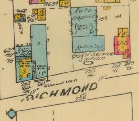
The 1922 fire insurance plan shows the vastness of the area at the time, and the future Whisper's building was the only structure at the intersection of Tweedsmuir (by then known as Strathcona) and Richmond Road.


The civic number of the building changed in the mid-20's as well, and was given the number 9 Richmond Road for the business, and 11 Richmond Road for the residence portion (the numbering was based on Richmond Road starting at Tweedsmuir, which was the eastern border of Westboro. Prior to Canada Post stepping in and enforcing addressing rules in the early 40's, villages could basically number their own buildings as they wished. So Westboro ignored the portion of Richmond Road to the east, which also had a 9 & 11 Richmond Road just east of Island Park Drive, in the village of what was known as "Ottawa West". Confusing to say the least).

Matt Larkin, manager of
"Matt's Place" (1929-1940)
By 1929, the address ceased to be listed as a grocery store, and instead was listed with the more panoptic term of "confectionery". Within a few years it also had a formal name, "Matt's Place". William and Mary's son Matthew took over operations of the store, while father William was likely back working in the contracting business. 

1937 Ottawa City Directory listing
for Richmond Road in Westboro,
showing Matt's Place at 9 Richmond.
However, the momentum of west Ottawa's growth shifted around this time, as the depression settled in, and finances became strained for all. Due to the stone cold real estate market in Ottawa, with new home construction stagnant, records indicate that the Larkins had to make a deal with the Dowlings, the mortgage-holders from back in 1916, and the house was sold to the Dowlings for the price of the mortgage balances, taxes and insurance owing (a total of $3,700). However, the Larkins continued to reside in the home, and operate Matt's Place for several more years.

Daniel and Fleur-Ange Larkin in front
of the store, circa late-1930s. This photo
gives the best view of the full front
window of the store.
Fleur-Ange (and Mary Larkin at the left
edge), late 1930s. Visible in this photo is
the name "Matt's Place" behind Fleur-Ange
in the window, as well as the small porch
that existed next to the 1919 front addition.
Sometime in December 1940 or very early 1941, the Larkins moved out of the house. As many of the kids had married and moved out, William and Mary moved to a smaller home in Ottawa. George and Mary Monsour, who had just married in 1939, moved in as the new tenants of the building. The Monsours continued operating the business, but gave it a new name: the Westboro Confectionery.

The Monsour's daughter Carolyn was born soon after, and so many years later recalled for me the details of the layout of the house. The ground floor was divided in two halves. The west half was the living and dining room for the residence (this would be the bar area of Whisper's today). The east half was entered through a door on the side of the small front addition. The Monsours operated a long lunch counter along the east wall of the store (where the huge TV screen now hangs), where they served burgers, hot dogs and fries to hungry customers. On the left side of the store portion was a long wall where they sold grocery items. The front window was filled with fruit, vegetables and penny candies. Carolyn recalled that her Dad was very generous with the neighbourhood children, giving the children free treats when they came to the shop with their parents, under the adage that "if you are good to the children, it will make the parents come back to the store".

The staircase to upstairs was in the same location it is now, and upstairs were the four bedrooms, which Carolyn lamented not having taken the opportunity to have a nostalgic look at when lunching at Whispers a few years ago (renovations within the last few years has now opened up the upstairs as additional restaurant space - very cozily done too, I might add).

In 1942, with the new post office requirements, the store was given the number it still has today, #249 Richmond Road (the residence portion was given #251). The Monsours lived upstairs, and for a while had Mrs Monsour's parents living with them as well.

After a couple of years, George Monsour purchased the property outright from the estate of Bessie Dowling, who had died in 1939. The Monsours paid $2,700 on January 19th, 1943.

Ottawa Citizen, December 30, 1944
At left is one of the few published advetisements taken out by the Monsours.


1948 Fire Insurance Plan, again showing the north side of Richmond
between Athlone (at left) and Tweedsmuir. 
Below are some great photos that Carolyn Monsour so generously shared with me. Each photo shows the front of the Westboro Confectionery, and a couple even have Mr. George Monsour as well.

George Monsour and daughter Carolyn
outside their store, mid-late 1940s.

The front window of the Westboro
Confectionery, mid-1940s

George Monsour inside the front window
of the Westboro Confectionery

George Monsour inside the window at a different date

The Pure Spring billboard which was located on the side
of the Westboro Confectionery - April 8 1946 (source: E00176
Sproul collection, City of Ottawa Archives) (this photo is just a
placeholder - I am waiting for the colour original from the Archives)

The Monsours continued to operate the Westboro Confectionery until the late 1950's. George Monsour began to feel unwell, and so in 1958 the family decided to lease out the business and residence. Sadly, George passed away a short time later in August of 1961.

On October 1st, 1958, the Monsours leased the property to Rizk (Ray) and Joseph Naufal. It was a 10-year lease, with rent at $250/month for the first year and $275/month for years two through nine. The rent was split $150/month for the shop (which increased to $175/month after the first year), plus $100/month for the residence portion of the house. The Naufals moved in upstairs, and kept the name Westboro Confectionery.

In July of 1968, Mary Monsour was listed as having sold the business to Helen Mains for $34,000. Mains immediately leased out the building to a Muriel Morrison, commencing December 1st on a 5-year lease at $450 per month to operate a "restaurant and coffee bar", but with the curious restriction: "...and the premises known as 251 Richmond will not during the term be at any time used for any other purpose than that of five rental units". This indicates that the residential living space upstairs and on the west side of the main floor was (or at least was intended to be) rented out in rooming-house style.

Morrison got out of the lease after six months (for unknown reasons) and starting June 1st, 1969, the premises were rented to Hal B. Ellis, who opened the "Ellis Coffee Bar". The four-and-a-half year lease was for $350 per month.

In May of 1972 Helen Mains, who by this time had moved to St. Catharines, sold the building to Rui De Lima and Emircio Garcia for $55,000. The pair had recently acquired the building next door at 255 Richmond and opened the Lusitania Auto Body Shop in 1970. The Ellis Coffee Bar continued to operate through most of the 1970s. I could track down nothing on Ellis or the Coffee Bar.

The front table at Sagres (from "The Key Ottawa/Hull 1979") 
1975 was the last year that occupants were listed as residing in the house. By 1977, the main floor was vacant as well. It was in early 1978 that De Lima and Garcia opened Sagres Restaurant, apparently Ottawa's first restaurant to specialize in Portugese food.


Ottawa Journal - June 7, 1979
Ottawa Journal - December 13, 1979


Sagres continued to operate until closing sometime in either late 1980 or early 1981. The business (under the name Sagres Restaurant Inc.) was purchased by Mike Kelly in July of 1981 for $75,000 and the restaurant re-opened as "Whispers".


Ottawa Citizen, October 2, 1981

In 1987, the business was sold to Don Cogan. I brought my camera in to Whispers last week and took a few photos of some photos from the late 1980's (pre-renovation) which hang on the walls of Whispers currently. They appear below:


In September of 1992, a site plan control was passed by the City of Ottawa, allowing for the expansion of the Whispers restaurant. The renovation allowed for the front expansion of the building, creating more seating area along the west side and front of the restaurant. The new footprint of the building is best shown in this aerial photo below from 2007:

Aerial photo (from 2007) showing the new Whispers
additions in 1992.
This photo below (also grabbed from the wall of Whispers) is of the staff soon after the renovations were complete:


Don Cogan brought in a co-owner in November of 2008 when long-time staff member Stacy Rennick bought in to Whispers.

On June 24th, 2011, fans of Whispers got a scare when fire crews were called to the restaurant around 8 in the morning. I came down Tweedsmuir that morning, and saw that Richmond Road was closed off due to a fire - at Whispers! Luckily it was caught early enough, and was contained to the roof and an upper floor wall. The cause of the fire was attributed to some neon lights that had recently been repaired.

June 24, 2011 - my cell phone snapped this photo through the misty
morning air, soon after the fire trucks had arrived on scene.

A current view of the front facade (from Whispers' website)

Whispers is entrenched as hub of the community - a place not only where people meet, but where events like book launches and concerts are held; where a hockey team can find a sponsor; a place, as one reviewer on Yelp said "as close as you're probably going to get to Cheers, the notorious Boston bar, in Ottawa". Even though over time the usage of the building has changed, the common thread through the years has been its tie-in to the neighbourhood. I love the fact that Carolyn Monsour shared a story about being recognized from the Westboro Confectionery last year by a former Tweedsmuir Avenue resident - impressive as the Monsours had left the store 57 years ago in 1958. I love the fact that the Larkin family still gets together on most St. Patrick's Days, and has a drink inside the home that their family patriarch William Larkin built over 100 years ago. And I love the fact that Whispers is still going strong, despite the changing neighbourhood, increased costs, higher taxes, increased competition, and all the other stuff that in many urban centres has killed off the good old fashioned neighbourhood pub.

Special thanks to Dan Larkin, Pat Larkin and Carolyn Monsour for all their help in sharing photographs,  stories and memories of 249 Richmond Road.