This week's new issue of the Kitchissippi Times features the first of a two-part article on the surprising history of Laroche Park. Recently Laroche Park was named the site of a Sens RINK, but it was delayed (and possibly cancelled) due to soil contamination. News reports and basic searching found little info on why it is contaminated, so I made it my mission to dig deep in the past and get the details. Why I unearthed shocked me! What a history this parcel of land has. You won't want to miss this article (and really cool photo) at the Kitchissippi Times: https://kitchissippitimes.wordpress.com/2015/11/13/laroche-park-westfest/
Part two will be in the next issue, due out November 26th. Cheers!
Friday, November 13, 2015
Sunday, November 8, 2015
Expanding on the old Richmond Road tollhouse & O'Neil house
In the Kitchissippi Times of October 15th (https://kitchissippitimes.wordpress.com/2015/10/16/landmark-building-of-wellington-st/), I wrote about the lot at the corner of Richmond Road and Island Park Drive, on which the Mizrahi development is slated to go. I detailed a little bit about the important history the lot holds, and profiled the house (now known as Bella's) which is going to be an innocent victim in the construction of a 12-storey condo building. The research I put in to the piece yielded a lot more information than I was able to put in the Times article, so I wanted to be sure to expand on both topics a little bit here on my blog (where I have no word count limits!).
So here is a little more info on the interesting history this important parcel of land has.
Going back in time, this property was part of the Cowley family farm which existed from Western Avenue to Patricia Avenue, back in the 19th century. The Cowleys had an old stone house, which was built closer to the Patricia edge of the property, which was lost to fire. No need for me to go too much into the Cowley history - it has already been done in a thorough and exciting manner by Mrs. Christine Jackson. I encourage you to check out her histories at:
http://champlainpark.files.wordpress.com/2014/09/cowley-family-part-1.pdf
http://champlainpark.files.wordpress.com/2014/09/cowley-family-part-2.pdf
https://champlainpark.files.wordpress.com/2013/03/cowley-part3_from-acr-fall-2015.pdf
It was from his parent's farmland that Robert H. Cowley in 1893 opened up one of the earliest subdivisions in Kitchissippi, when this area was still truly little more than open farmland. He created a plan for "Ottawa West", which was Plan 145 of Carleton County (this area was still in Nepean Township, and would not become part of Ottawa until 1950).
Island Park Drive was still 30+ years away from being created (just to the west of the subdivision), and Wellington Village (from Western to Holland) was just under 30 years away. Westboro was still not even Westboro yet.
By the spring of 1895, the first two houses were complete in the new subdivision at 5 Gould Street (demolished in 2007) and at what is now 41 Garrison Street (formerly Perth Street), which I think still exists, at least in some form, inside the house which was significantly renovated and expanded 10 years ago.
One or two other houses were built during the summer of 1895, but it would be in the fall of 1895 when the first construction of significance would occur.
I'll break the history of this property (the Mizrahi property) into the three (well, three and a half) separate lots that it is (lots 1, 2, 3 and 4 on Richmond Road) - see the plan above for the location of these lots. Essentially they are each 50 feet wide. The most westerly 50 feet (lot 1) is the office and parking lot portion of the car wash/gas station property; lot 2 is the service bay portion of the car wash; and lot 3 (and west half of 4) is Bella's.
Lot #1
As mentioned in the article, Richmond Road at the time, actually all the way back to 1853, had been a toll road. Two booths were set up at either end, and travelers on the road had to pay a toll in order to use it. The fees were used to maintain the street, and keep it clear. The toll booth at the western end was in Bells Corners, and at the eastern end, seven miles away, was in Hintonburg (though still several years away from actually being called "Hintonburg").
The toll booth was originally located on Richmond Road, on the west side of what is now Parkdale (at the time Parkdale was probably no more than a dusty lane, if that, north to the River, and south up to the concession road, aka Carling Avenue). It would later be known as Queen Street into the 20th century.
This first Hintonburg tollhouse burned down in 1883, and was replaced with a new building a little east of Parkdale, at what is now 1121 Wellington Street (the building still stands today as Tony's Shoe Repair). A fire in March of 1888 led to some rebuilding, but essentially the building is the same 130 years later.
Hintonburg elected to become an independent village in December of 1893, chiefly over their battle to allow the Ottawa Electric Railway to lay tracks down Wellington Street. With the streetcars coming, the Bytown and Nepean Road Company had to move the toll house. It was decided that it would be best to move the toll house beyond Hintonburg's limits, which in 1893 was today's Western Avenue. Cowley's new subdivision was an ideal spot, so the Road Company purchased the lot at the western edge.
The Company paid Cowley $275 for the lot on November 15th, 1895. They paid well-known Ottawa architect Moses C. Edey $78.75 (5% of the cost of construction) for him to prepare plans and superintend erection, and they paid Clement I Amey, builder of the toll house, $1,575.25, which included a $2.25 overage for extra wire fencing.
The Company sold Richmond Road to the Electric Railway Company on October 11th, 1895, and streetcar tracks began to be laid soon after. A tiny notice in the Journal the next day listed all of these incredible highlights in one brief paragraph (see at right).
Construction of the toll house was completed in the fall of 1895.
Built were a tollhouse, where the toll collector would live, and a woodshed. The house was built with the following specifications: "balloon-frame, 20 ft x 26 ft, 1 1/2 storeys high, with frame kitchen 12 ft x 14 ft 1 storey high, all to be sheeted inside and out with rough boards, felted inside and out, clapboarded with good quality of lumber and painted, all on stone foundation; said house to have shingled roof and one brick chimney."
The toll booth would remain in operation until February of 1920.
Unfortunately, I could not locate a good street-level photograph of it (my search continues though!), but I do have a few items which help demonstrate what it looked like.
Firstly is a clip from a 1915 Fire Insurance Plan, showing the structures along Richmond Road. The one at the far left is the toll house, which is shown with its approximate shape, size, and location. What makes this drawing interesting is the detail in how it shows the "toll gate office" built right on Richmond Road, and the thin little walkway which existed between the house and office.
And below, a few aerial photographs from the National Aerial Photo Library which show the area with a fair bit of clarity and detail (particularly considering the photos are 100 years old, and as you can imagine, both photography and airplanes were still primitive at the time):
Though sadly I cannot located a photo of the original toll house in action, the Ottawa Citizen in the 1950s produced this illustration showing an artist's example of a 19th century Ottawa toll gate. This drawing is likely not too far off what the original looked like:
Lot #2
This lot was originally purchased by long-time Carleton County Schools Inspector Archibald Smirle (for whom Smirle Avenue is named, and who resided on Richmond Road a little further east, not-too-coincidentally at the corner of Smirle. But more on him in an upcoming blog post later this week). Smirle purchased this lot on July 15th, 1896, perhaps for investment purposes, but died a year later. His daughters sat on the property for a few years, before finding a buyer in 1908 - tollkeeper Ashburn E. Bradley.
Bradley purchased the lot for $330, and constructed a home between 1910 and 1911. It was finished by the township assessor's visit on April 20th, and 11 days later he gave up the position of tollkeeper and moved next-door into his new house. I can only guess that Bradley smartly used his free time in between collecting tolls to work outside constructing a home next door, and then moved in once completed.
Bradley's 2 1/2-storey brick veneered house was originally used as a grocery store and post office in 1911 (it is noted as such in the 1915 fire insurance plan posted above). Bradley worked as Ottawa West's postmaster for a year, before renting the house out to 73-year old David P. Brown, retired contractor from North Gower, who took over the grocer/butcher/postmaster role for two years. By 1915, 21-year old Edgar King took over the grocery shop for a year, though the Postmaster position was given to Henry Porteous, who operated a grocery store out of a house at the northwest corner of Carleton and Richmond.
By 1916, the home's brief run as a grocery shop had ended. There was much competition on Richmond Road in the vicinity, including of course Shouldice Brothers on the northeast corner of Carleton, in what is now Metro's parking lot; not to mention the area's population was still small. Hampton Park was just a couple of years new, Cowley's subdivision had prospered, but there was really little else built between Hilson and Holland. In 1916, Bradley was listed as having moved back in to the house, while he began working as a conductor for the Ottawa Electric Railway.
In 1919, Bradley sold the house to soldier William R. Delaney and his family. Delaney ended up being posted to Winnipeg between 1926-1928, so he rented to William Tiva and family, a driver. They would be the last to reside in the house, when Delaney sold to Cities Oil in 1929. This house too would be demolished in 1930 to make way for the gas station.
I have no photo of this house either, but the 1922 fire insurance plan has some neat detail of the incredible number of outer buildings that existed on the property at the time:
Lot #3 (and part of lot #4)
Expanding a bit on the history of the house (now Bella's restaurant) which I covered in the article, the house was built during 1896 by Joseph O'Neil. He acquired the lot sometime in the spring, prior to the assessment roll being drawn up on April 22nd (it was not uncommon in this era for land transactions to not be registered at the registry office until months or sometimes years after the fact; Cowley was one such real estate dealer who operated this way. He would sometimes sell a lot, even lend money and assist the purchaser to build, but not register the transaction for some time). The transaction was officially registered as August 19th, 1897, but that was well over a year after it actually occurred.
Work was ongoing into the winter of 1896-1897, and in a cool stroke of luck, the Ottawa Journal even commented on its construction progress on the 30th of December, 1896.
J.G. Clark mentioned in the article above was constructing a home on the north-west corner of Richmond and Carleton, which was for a long time owned by Henry Porteous.
So back to the O'Neil house, as mentioned in the article O'Neil was a millwright, and in 1896 was 34 years old when he built this house. He was married in 1888 to the former Mary Ann Wilson (born 1862). They had children William Clarence (1889-1969), Thomas Wilson (1893-1964), John Ernest (1896-1961), twins Pearl E (1898-1986) and Joseph Wilbert (1898-1953), and Harold I. (1901-1969), I believe that Mary O'Neil actually had given birth to two sets of twins, but one of one of the twins passed away in infancy.
The 1901 Census also listed Joseph's brother John, John's wife and their two children Myrtle (age 6) and Clara (age 4) as residing in the home on Richmond Road as well. That would be 12 people residing in the house as of 1901. Interesting to think of today, but not all that uncommon for that era.
Joseph died on March 15th, 1903 in Byng Inlet, near Parry Sound, while working on the construction of a sawmill. He was 41 (newspaper accounts giving his age of 38 were incorrect).
After Joseph died, Mary Ann remained in the home with her children, and made it work, despite what must have been a difficult life for her alone with the six children.
On August 24th, 1903, five months after Joseph's passing, Mary Ann O'Neil acquired the lot next door, lot 4 on Richmond Road, from Robert H. Cowley, for the deeded sale price of $1. There is no way to confirm it, but Cowley may have gifted the lot to O'Neil after losing her husband. From all accounts Cowley was a very generous man, and by 1903 he still owned the vast majority of the lots in the subdivision. So the gifting of one lot, worth about $200 to $300, was something he could easily afford, and may have helped Mary Ann and the family by giving them a larger lot and/or a little extra financial stability/insurance by virtue of the additional land ownership.
The O'Neils did not do anything with the extra lot, and 50 feet of frontage on Richmond Road, other than probably use it for extra family space. It would be not until 1930 that O'Neil sold the east half of the lot to Louis Baker, of the well-known Baker Brothers outfit, who were LeBreton Flats-based auto wreckers and junk dealers. Louis Baker also acquired lot 5 that year, and he had constructed two houses on his new lots in 1930. These two houses, as well as the Porteous house mentioned above (27, 31 and 33 Richmond Road) were all torn down in the early 80s to make way for the construction of a single-storey commercial plaza which included a Quickie Convenience Store and Tommy's Donuts, and which was recently razed as well, replaced by "The Wellington at Island Park" condo building.
Meanwhile, the west half of lot 4 remained with O'Neil, and in fact is still part of the Bella's property today, which explains the extra-large parking lot the restaurant has been able to use to its advantage over the years.
I am indebted to Mrs. Heather Backs, daughter of Thomas Wilson O'Neil, for sharing some stories about her grandparents and the house on Richmond Road, and for helping me eventually connect to the right family member who had the wonderful photo of the house from the 1920s, as well as the photo of Joseph and Mary Ann O'Neil above. She still has many fond memories of the home, including her earliest childhood memories of her grandmother's sugar cookies which were kept in a tin up high in the kitchen; she recalls that before she was old enough to talk, she could point at the tin of cookies.
As I mentioned in the Times, Joseph O'Neil had also built the stone house on Churchill Avenue near Scott which is now home to the law firm of Farber, Robillard and Leith. Mrs. Backs noted that her Dad Thomas had been born in that house, in 1893.
Mrs. Backs told me that it breaks her heart that her family's home will likely be torn down soon. She feels it should be designated in some way, and of course I agree. Perhaps I am just a little too late in trying to defend the house, and I wish I had started making efforts a few years ago to have some homes of heritage significance properly recognized. Unfortunately, the O'Neil home has without any thought been considered a simple tear-down through this process. Not surprisingly, Mizrahi doesn't care about the old house, and surprisingly the owners of Bella's appear to care little either; I was a little surprised to see the owners at the City Planning Committee meeting 2 weeks ago arguing on behalf of Mizrahi and the "landmark" design. But I guess it shouldn't be all that surprising, considering they sold the lot to Mizrahi, and profited from that, and at one time during the process, were also promised to be able to re-open Bella's in the main floor of the new condo building (not sure if that's still the case).
But back to Mrs. Backs, she spoke so highly of her grandmother, and understandably so. She shared that Mary Ann had been so resourceful, particularly as she had little education, and was the eldest of 12 children in Dunrobin. Her mother died at a young age, and she essentially helped raise all her brothers and sisters. Her escape to Kitchissippi to marry Joseph O'Neil in 1888 was a second phase of raising children, but from the sounds of it, she did it happily and lovingly, working hard in whatever work she could take in, until the eldest sons were able to go to work. A great story of perseverance, strength and family, from the early days of Kitchissippi.
So here is a little more info on the interesting history this important parcel of land has.
Going back in time, this property was part of the Cowley family farm which existed from Western Avenue to Patricia Avenue, back in the 19th century. The Cowleys had an old stone house, which was built closer to the Patricia edge of the property, which was lost to fire. No need for me to go too much into the Cowley history - it has already been done in a thorough and exciting manner by Mrs. Christine Jackson. I encourage you to check out her histories at:
http://champlainpark.files.wordpress.com/2014/09/cowley-family-part-1.pdf
http://champlainpark.files.wordpress.com/2014/09/cowley-family-part-2.pdf
https://champlainpark.files.wordpress.com/2013/03/cowley-part3_from-acr-fall-2015.pdf
It was from his parent's farmland that Robert H. Cowley in 1893 opened up one of the earliest subdivisions in Kitchissippi, when this area was still truly little more than open farmland. He created a plan for "Ottawa West", which was Plan 145 of Carleton County (this area was still in Nepean Township, and would not become part of Ottawa until 1950).
 |
| Plan 145 (1893): the "Ottawa West" subdivision. Scott Street at the top and Richmond Road at bottom. |
By the spring of 1895, the first two houses were complete in the new subdivision at 5 Gould Street (demolished in 2007) and at what is now 41 Garrison Street (formerly Perth Street), which I think still exists, at least in some form, inside the house which was significantly renovated and expanded 10 years ago.
One or two other houses were built during the summer of 1895, but it would be in the fall of 1895 when the first construction of significance would occur.
I'll break the history of this property (the Mizrahi property) into the three (well, three and a half) separate lots that it is (lots 1, 2, 3 and 4 on Richmond Road) - see the plan above for the location of these lots. Essentially they are each 50 feet wide. The most westerly 50 feet (lot 1) is the office and parking lot portion of the car wash/gas station property; lot 2 is the service bay portion of the car wash; and lot 3 (and west half of 4) is Bella's.
Lot #1
As mentioned in the article, Richmond Road at the time, actually all the way back to 1853, had been a toll road. Two booths were set up at either end, and travelers on the road had to pay a toll in order to use it. The fees were used to maintain the street, and keep it clear. The toll booth at the western end was in Bells Corners, and at the eastern end, seven miles away, was in Hintonburg (though still several years away from actually being called "Hintonburg").
 |
| 1879 Map of Bells Corners, showing the toll booth on the western edge of the village, roughly at where Stinson now ends at Robertson. The double line between the words "Bells" and "Corners" would be today's Moodie Drive. |
 |
| 1879 Map of Hintonburg, showing the toll gate at the corner of Wellington and what is now Parkdale, at the eastern edge of the R.J. Hinton property |
The toll booth was originally located on Richmond Road, on the west side of what is now Parkdale (at the time Parkdale was probably no more than a dusty lane, if that, north to the River, and south up to the concession road, aka Carling Avenue). It would later be known as Queen Street into the 20th century.
This first Hintonburg tollhouse burned down in 1883, and was replaced with a new building a little east of Parkdale, at what is now 1121 Wellington Street (the building still stands today as Tony's Shoe Repair). A fire in March of 1888 led to some rebuilding, but essentially the building is the same 130 years later.
Hintonburg elected to become an independent village in December of 1893, chiefly over their battle to allow the Ottawa Electric Railway to lay tracks down Wellington Street. With the streetcars coming, the Bytown and Nepean Road Company had to move the toll house. It was decided that it would be best to move the toll house beyond Hintonburg's limits, which in 1893 was today's Western Avenue. Cowley's new subdivision was an ideal spot, so the Road Company purchased the lot at the western edge.
The Company paid Cowley $275 for the lot on November 15th, 1895. They paid well-known Ottawa architect Moses C. Edey $78.75 (5% of the cost of construction) for him to prepare plans and superintend erection, and they paid Clement I Amey, builder of the toll house, $1,575.25, which included a $2.25 overage for extra wire fencing.
 |
| Ottawa Journal - October 12, 1895 |
Construction of the toll house was completed in the fall of 1895.
Built were a tollhouse, where the toll collector would live, and a woodshed. The house was built with the following specifications: "balloon-frame, 20 ft x 26 ft, 1 1/2 storeys high, with frame kitchen 12 ft x 14 ft 1 storey high, all to be sheeted inside and out with rough boards, felted inside and out, clapboarded with good quality of lumber and painted, all on stone foundation; said house to have shingled roof and one brick chimney."
The toll booth would remain in operation until February of 1920.
Unfortunately, I could not locate a good street-level photograph of it (my search continues though!), but I do have a few items which help demonstrate what it looked like.
Firstly is a clip from a 1915 Fire Insurance Plan, showing the structures along Richmond Road. The one at the far left is the toll house, which is shown with its approximate shape, size, and location. What makes this drawing interesting is the detail in how it shows the "toll gate office" built right on Richmond Road, and the thin little walkway which existed between the house and office.
 |
| 1915 fire insurance plan |
And below, a few aerial photographs from the National Aerial Photo Library which show the area with a fair bit of clarity and detail (particularly considering the photos are 100 years old, and as you can imagine, both photography and airplanes were still primitive at the time):
 |
| Aerial photo 1920 showing Richmond Road. The 1920 aerial photos are the oldest that exist. The tollgate had been removed earlier this same year. |
 |
| Aerial photo November 1928 showing Richmond Road, with the new Island Park Drive now cutting through. This is the best photo I have that shows the detail (from above) of the toll house, the first house to the right of Island Park Drive on the north side of Richmond Road. |
Though sadly I cannot located a photo of the original toll house in action, the Ottawa Citizen in the 1950s produced this illustration showing an artist's example of a 19th century Ottawa toll gate. This drawing is likely not too far off what the original looked like:
 |
| Ottawa Citizen, August 8th, 1953. |
The toll collector was required to live in the house, and essentially was expected to work 24 hours a day, 7 days per week. The rate of pay was $1 per day, for all days of the year, with a small bonus of $10 paid in December, if the quality of work had been good during the year.
The brave souls who acted as toll collectors during the period the tollbooth was open in this location were:
John A. Owens: 2 August 1894 (he had been collector at the Hintonburg location) to 1 April 1903
Erasmus T. Duke: 1 April 1903 to 1 May 1908
Ashburn E. Bradley 1 May 1908 to 1 May 1911
Richard Bassett: 1 May 1911 to 31 Jan 1913
Justus P. Merrifield: 1 Feb 1913 to 29 Feb 1920
Here is a copy of the Tariff of Tolls issued by the B&NRC in 1881, showing the price to travel from the tollgate to certain points on the route. The price varied based on the season (summer or winter), the number of horses, and if a vehicle (carriage or cart) was present:

The Richmond Road toll road closed in 1920 after Carleton County expropriated the roadway and the tollhouses from the Bytown and Nepean Road Company (as well as the Nepean and North Gower Consolidated Road Company, the Ottawa Gloucester Road Company, and the Ottawa, Montreal and Russell Road Company). The transfer of all these toll roads occurred on February 7th, 1920
The end of the toll road era in Ottawa was celebrated by the general public and media alike. The editorial in the Ottawa Journal later that month noted "a relic of the mid-Victorian era, the toll roads should have been done away with a quarter of a century ago. Ottawa was one of the last of municipalities to continue to endure them and their retention was not only a nuisance but a poor advertisement for the city. Legal difficulties and the lack of sufficiently concerted effort on the part of the city and the rural municipalities have for many years stood in the way of the taking over of the roads from the private owners."
In the end, Carleton County paid the Bytown and Nepean Road Company $35,000 for the road (as decided by an arbitrator in 1922).
Once title of the road and tollhouses were put in the name of Carleton County officially, they were able to sell the two properties. The toll house on Richmond Road was sold to the former tollkeeper, Justus P. Merrifield and his wife Annie, for $3,500 in August of 1922.
The Merrifields would remain in the house until October 1929, when they sold to Bernard S. Rumsby of the Cities Service Oil Company. Within a short time, the house was torn down, to make way for the Cities gas station constructed by 1930.
The gas station was often referred to by it's manager, and this station had a long list of different managers over the years that I could easily dig up:
1938-39: Fred A. Farmer
1940: Ray Temple
1941: Dale & O'Meara
1942: Paul Gauthier
1943: Oscar Mastin
1948: Fred Farmer again
1953: Bert Steele
1955: Bob Bradley
1958-59: Doug Dunn
1960: Albert & Galarneau
1961: Les McCrum
1962: was known as "Parkway Garage"
1964: was known as "Island Park Cities Service Station"
It remained a Cities station until 1964 when they sold to BP Canada, then in 1973 to Frisby Tire, 1974 to Joe's Car Radio & TV, and finally in 2007 to Pro-Shine Car Wash.
The brave souls who acted as toll collectors during the period the tollbooth was open in this location were:
John A. Owens: 2 August 1894 (he had been collector at the Hintonburg location) to 1 April 1903
Erasmus T. Duke: 1 April 1903 to 1 May 1908
Ashburn E. Bradley 1 May 1908 to 1 May 1911
Richard Bassett: 1 May 1911 to 31 Jan 1913
Justus P. Merrifield: 1 Feb 1913 to 29 Feb 1920
Here is a copy of the Tariff of Tolls issued by the B&NRC in 1881, showing the price to travel from the tollgate to certain points on the route. The price varied based on the season (summer or winter), the number of horses, and if a vehicle (carriage or cart) was present:

The Richmond Road toll road closed in 1920 after Carleton County expropriated the roadway and the tollhouses from the Bytown and Nepean Road Company (as well as the Nepean and North Gower Consolidated Road Company, the Ottawa Gloucester Road Company, and the Ottawa, Montreal and Russell Road Company). The transfer of all these toll roads occurred on February 7th, 1920
 |
| Ottawa Journal - Saturday February 7, 1920 |
The end of the toll road era in Ottawa was celebrated by the general public and media alike. The editorial in the Ottawa Journal later that month noted "a relic of the mid-Victorian era, the toll roads should have been done away with a quarter of a century ago. Ottawa was one of the last of municipalities to continue to endure them and their retention was not only a nuisance but a poor advertisement for the city. Legal difficulties and the lack of sufficiently concerted effort on the part of the city and the rural municipalities have for many years stood in the way of the taking over of the roads from the private owners."
In the end, Carleton County paid the Bytown and Nepean Road Company $35,000 for the road (as decided by an arbitrator in 1922).
Once title of the road and tollhouses were put in the name of Carleton County officially, they were able to sell the two properties. The toll house on Richmond Road was sold to the former tollkeeper, Justus P. Merrifield and his wife Annie, for $3,500 in August of 1922.
The Merrifields would remain in the house until October 1929, when they sold to Bernard S. Rumsby of the Cities Service Oil Company. Within a short time, the house was torn down, to make way for the Cities gas station constructed by 1930.
The gas station was often referred to by it's manager, and this station had a long list of different managers over the years that I could easily dig up:
1938-39: Fred A. Farmer
1940: Ray Temple
1941: Dale & O'Meara
1942: Paul Gauthier
1943: Oscar Mastin
1948: Fred Farmer again
1953: Bert Steele
1955: Bob Bradley
1958-59: Doug Dunn
1960: Albert & Galarneau
1961: Les McCrum
1962: was known as "Parkway Garage"
1964: was known as "Island Park Cities Service Station"
It remained a Cities station until 1964 when they sold to BP Canada, then in 1973 to Frisby Tire, 1974 to Joe's Car Radio & TV, and finally in 2007 to Pro-Shine Car Wash.
Lot #2
This lot was originally purchased by long-time Carleton County Schools Inspector Archibald Smirle (for whom Smirle Avenue is named, and who resided on Richmond Road a little further east, not-too-coincidentally at the corner of Smirle. But more on him in an upcoming blog post later this week). Smirle purchased this lot on July 15th, 1896, perhaps for investment purposes, but died a year later. His daughters sat on the property for a few years, before finding a buyer in 1908 - tollkeeper Ashburn E. Bradley.
Bradley purchased the lot for $330, and constructed a home between 1910 and 1911. It was finished by the township assessor's visit on April 20th, and 11 days later he gave up the position of tollkeeper and moved next-door into his new house. I can only guess that Bradley smartly used his free time in between collecting tolls to work outside constructing a home next door, and then moved in once completed.
Bradley's 2 1/2-storey brick veneered house was originally used as a grocery store and post office in 1911 (it is noted as such in the 1915 fire insurance plan posted above). Bradley worked as Ottawa West's postmaster for a year, before renting the house out to 73-year old David P. Brown, retired contractor from North Gower, who took over the grocer/butcher/postmaster role for two years. By 1915, 21-year old Edgar King took over the grocery shop for a year, though the Postmaster position was given to Henry Porteous, who operated a grocery store out of a house at the northwest corner of Carleton and Richmond.
By 1916, the home's brief run as a grocery shop had ended. There was much competition on Richmond Road in the vicinity, including of course Shouldice Brothers on the northeast corner of Carleton, in what is now Metro's parking lot; not to mention the area's population was still small. Hampton Park was just a couple of years new, Cowley's subdivision had prospered, but there was really little else built between Hilson and Holland. In 1916, Bradley was listed as having moved back in to the house, while he began working as a conductor for the Ottawa Electric Railway.
In 1919, Bradley sold the house to soldier William R. Delaney and his family. Delaney ended up being posted to Winnipeg between 1926-1928, so he rented to William Tiva and family, a driver. They would be the last to reside in the house, when Delaney sold to Cities Oil in 1929. This house too would be demolished in 1930 to make way for the gas station.
I have no photo of this house either, but the 1922 fire insurance plan has some neat detail of the incredible number of outer buildings that existed on the property at the time:
 |
| 1922 Fire Insurance Plan, showing the former toll house, the Bradley-Delaney house, the O'Neil house, and the Porteous house, all along Richmond, west of Carleton. |
Lot #3 (and part of lot #4)
Expanding a bit on the history of the house (now Bella's restaurant) which I covered in the article, the house was built during 1896 by Joseph O'Neil. He acquired the lot sometime in the spring, prior to the assessment roll being drawn up on April 22nd (it was not uncommon in this era for land transactions to not be registered at the registry office until months or sometimes years after the fact; Cowley was one such real estate dealer who operated this way. He would sometimes sell a lot, even lend money and assist the purchaser to build, but not register the transaction for some time). The transaction was officially registered as August 19th, 1897, but that was well over a year after it actually occurred.
Work was ongoing into the winter of 1896-1897, and in a cool stroke of luck, the Ottawa Journal even commented on its construction progress on the 30th of December, 1896.
 |
| Ottawa Journal - December 30, 1896 |
So back to the O'Neil house, as mentioned in the article O'Neil was a millwright, and in 1896 was 34 years old when he built this house. He was married in 1888 to the former Mary Ann Wilson (born 1862). They had children William Clarence (1889-1969), Thomas Wilson (1893-1964), John Ernest (1896-1961), twins Pearl E (1898-1986) and Joseph Wilbert (1898-1953), and Harold I. (1901-1969), I believe that Mary O'Neil actually had given birth to two sets of twins, but one of one of the twins passed away in infancy.
 |
| Joseph O'Neil (builder of 1445 Wellington Street) and wife Mary Ann O'Neil. |
The 1901 Census also listed Joseph's brother John, John's wife and their two children Myrtle (age 6) and Clara (age 4) as residing in the home on Richmond Road as well. That would be 12 people residing in the house as of 1901. Interesting to think of today, but not all that uncommon for that era.
Joseph died on March 15th, 1903 in Byng Inlet, near Parry Sound, while working on the construction of a sawmill. He was 41 (newspaper accounts giving his age of 38 were incorrect).
 |
| Ottawa Journal, March 17, 1903 |
 |
| O'Neil family children (around 1906-1907) |
On August 24th, 1903, five months after Joseph's passing, Mary Ann O'Neil acquired the lot next door, lot 4 on Richmond Road, from Robert H. Cowley, for the deeded sale price of $1. There is no way to confirm it, but Cowley may have gifted the lot to O'Neil after losing her husband. From all accounts Cowley was a very generous man, and by 1903 he still owned the vast majority of the lots in the subdivision. So the gifting of one lot, worth about $200 to $300, was something he could easily afford, and may have helped Mary Ann and the family by giving them a larger lot and/or a little extra financial stability/insurance by virtue of the additional land ownership.
The O'Neils did not do anything with the extra lot, and 50 feet of frontage on Richmond Road, other than probably use it for extra family space. It would be not until 1930 that O'Neil sold the east half of the lot to Louis Baker, of the well-known Baker Brothers outfit, who were LeBreton Flats-based auto wreckers and junk dealers. Louis Baker also acquired lot 5 that year, and he had constructed two houses on his new lots in 1930. These two houses, as well as the Porteous house mentioned above (27, 31 and 33 Richmond Road) were all torn down in the early 80s to make way for the construction of a single-storey commercial plaza which included a Quickie Convenience Store and Tommy's Donuts, and which was recently razed as well, replaced by "The Wellington at Island Park" condo building.
Meanwhile, the west half of lot 4 remained with O'Neil, and in fact is still part of the Bella's property today, which explains the extra-large parking lot the restaurant has been able to use to its advantage over the years.
Mary O'Neil lived a long life, passing away in August of 1953 at the age of 91. Her son Clarence O'Neil remained in the house until the late 1960s. He purchased the property off his Mom in June of 1950. He did not marry until late in his life, marrying long-time friend Edith Bennie when he was in his 70s. Clarence sold the O'Neil family home in November of 1967 to Charlotte I. Innes, for the price of $38,000, and the couple moved to a smaller home on Laurentian Place. He passed away October 23rd, 1969 at the age of 80.
As I mentioned in the Times, Joseph O'Neil had also built the stone house on Churchill Avenue near Scott which is now home to the law firm of Farber, Robillard and Leith. Mrs. Backs noted that her Dad Thomas had been born in that house, in 1893.
Mrs. Backs told me that it breaks her heart that her family's home will likely be torn down soon. She feels it should be designated in some way, and of course I agree. Perhaps I am just a little too late in trying to defend the house, and I wish I had started making efforts a few years ago to have some homes of heritage significance properly recognized. Unfortunately, the O'Neil home has without any thought been considered a simple tear-down through this process. Not surprisingly, Mizrahi doesn't care about the old house, and surprisingly the owners of Bella's appear to care little either; I was a little surprised to see the owners at the City Planning Committee meeting 2 weeks ago arguing on behalf of Mizrahi and the "landmark" design. But I guess it shouldn't be all that surprising, considering they sold the lot to Mizrahi, and profited from that, and at one time during the process, were also promised to be able to re-open Bella's in the main floor of the new condo building (not sure if that's still the case).
But back to Mrs. Backs, she spoke so highly of her grandmother, and understandably so. She shared that Mary Ann had been so resourceful, particularly as she had little education, and was the eldest of 12 children in Dunrobin. Her mother died at a young age, and she essentially helped raise all her brothers and sisters. Her escape to Kitchissippi to marry Joseph O'Neil in 1888 was a second phase of raising children, but from the sounds of it, she did it happily and lovingly, working hard in whatever work she could take in, until the eldest sons were able to go to work. A great story of perseverance, strength and family, from the early days of Kitchissippi.
 |
| Aerial photo from 1933, showing the new Cities gas station, the O'Neil house, and the trio of houses towards Carleton. |
 |
| Aerial photo from 1965. The traffic circle is gone, the gas station has been rebuilt, and the whole area has certainly gotten a lot busier. |
 |
| Photograph of the house from the mid-1980s, when it was "Chez-Soi", a French restaurant (photo courtesy of the archives of Newswest). |
 |
| My vintage Chez Soi matchbook (found a few weeks ago at Crazy Carl's on Armstrong - thanks again Carl!) |
Friday, October 16, 2015
The true "landmark" building of Wellington West; a historical look at the controversial Mizrahi lot
This week's issue of the Kitchissippi Times is out, and features an article I wrote about the corner of Island Park Drive and Richmond, and particularly the controversial lot on the north-east corner which is the potential site of a 12-storey building by developer Mizrahi. Check out the link below to learn more about the really interesting history this lot has had, including it's years as a toll house, a gas station, and especially the original Wellington Street house which still exists today... but sadly not for long...
https://kitchissippitimes.wordpress.com/2015/10/16/landmark-building-of-wellington-st/
Check back this weekend, I'll have an expanded history of the lot posted here, including a lot more details on the old toll house (I'm limited in # of words in the newspaper, but on here I can ramble on in as much details as I like!).
Cheers!
Tuesday, October 13, 2015
When the telephone arrived in Kitchissippi
I came across this news nugget a while back, which highlights the arrival of the telephone in Kitchissippi (or at least the western part of Kitchissippi, west of probably Holland Avenue):
Just a tiny article buried deep inside the Journal on a Friday in 1906, but it represents such a significant milestone for our area. So to clarify the mentioned locations a little bit, Ottawa West was the original Cowley subdivision created in the 1890s between what is now Western and Rockhurst, and bordered by Scott and Wellington. Cleary's was a popular hotel on Richmond Road operated by Daniel Cleary for more than 30 years from approx. 1880 until 1910 (in the vicinity of Cleary Avenue; incidentally, Daniel was the younger brother of Glebe real estate trader and politician Thomas Clarey, and in numerous records both brothers go by the alternate spellings of Clarey and Cleary. Both had streets named for them, but with the two different spellings!). And thirdly, "Woodruffe" of course is an early spelling of what is now Woodroffe.
Telephones would have likely been located in the post office or general store of each of the two mentioned communities. In 1906, the Ottawa West post office was located in the toll gate office on Richmond Road operated by toll keeper Erasmus Duke, and makes for a logical location for the community's first telephone.
The Ottawa Citizen of July 16, 1906 noted as well that Riverside Park (the original name for the Champlain Park community) obtained phone service in 1906:
So 1906 really was a year of advancement for the west end of Ottawa, with the important arrival of the telephone.
This got me thinking about when the telephone was first introduced to Ottawa as a whole. So I started searching around on the net, and found a few details about it, and thought I'd include a few tidbits of trivia on the subject.
So the telephone's introduction to Ottawa is linked to Alexander Graham Bell as you may have guessed, but not as directly as you may have expected. In the mid-1870s, Bell had turned over his Canadian patent rights to his father Alexander Melville Bell, who then began promoting the telephone in Canada for the first time. Alexander Jr. had made the first telephone call on March 10, 1876 from one room to another within a house in Boston, Mass. It was just a year later that the telephone was first brought to Ottawa in 1877, by William S. Pettigrew, who had met the senior Bell on a boatride from Montreal to Ottawa (side note: when was the last time you heard of someone taking a boat ride from Montreal?). The two men of Scottish backgrounds became instant friends, and Pettigrew became Bell's agent in Ottawa.
Thus in September of 1877, Pettigrew made the first public demonstration of the telephone at the Ex (then known as the Ottawa Agricultural Exposition).
The first usage of a telephone in Ottawa came shortly afterwards, when Prime Minister Alexander Mackenzie had Pettigrew install a private line between his office downtown at the Public Works building near Parliament Hill to Rideau Hall.
Ottawa historian Harry Walker wrote that the PM's secretary William Buckingham was responsible for testing the first call. Located at Rideau Hall. He described the moment: "...this impersonal box-like thing made him nervous. Finally from out of the box came a voice. It was the Prime Minister making contact from his other office in the West Block where he doubled as Minister of Public Works. Buckingham was thrown off stance by having to talk into a mouth piece before what he knew would be a listening group of Cabinet Ministers. In his braid Scotch burr, the Prime Minister instructed Buckingham to say the Lord's Prayer. Buckingham botched it. The Presbyterian Prime Minister...told Buckingham to listen while he repeated the Prayer for Buckingham's benefit. Buckingham was relieved, but only momentarily, for Mackenzie would not let him off the hook insisting that he try it a second time. The reluctant secretary was better on the second try. Then the whole room of guests heard the Prime Minister admonish the hapless secretary: "You have got it all right now, Buckingham, but don't you ever forget it again." Then the Prime Minister formally opened the first telephone service in the Capital by talking with the Governor General. What they said to each other over a copper wire never made the record. But Buckingham's bumbling recital of the Lord's Prayer lived in history as it deserved to."
These first wooden box phones were not overly popular, due to the fact that user had to speak in to and listen through the same opening, and often parts of conversations were lost.
An Ottawa Citizen article in 1961 recalled the initial dissatisfaction in early phone service: "Mr. Pettigrew recalled that the telephone did not always work very well and the Prime Minister wanted it removed. However, music was invariably transmitted successfully and Lady Dufferin would sing and play the piano at Rideau Hall and the music would be heard distinctly in the departmental building, two miles away. And at the Ottawa end, Captain Gourdeau would sing for the edification of Lady Dufferin and Rideau Hall. Lord Dufferin countermanded the Prime Minister's order and the telephone stayed."
The Bell Telephone Company was created in November of 1880, combining the two competing upstart telephone systems which had been established earlier in the year (the Dominion Telegraph Company, managed by Warren Soper, and the Montreal Telephone Company, managed by Thomas Ahearn). Ahearn and Soper would go on to manage countless organizations in Ottawa (they formed the Ottawa Electric Company, the Ottawa Electric Railway, the Ottawa Land Association, etc.), and are arguably the most influential businessmen in Ottawa's history.
By the 1880s, wall sets were developed which featured a double transmitter-receiver, so that a user could speak into the receiver and listen to the ear piece. The crank on the side would generate the power required to call the operator. This type of phone was common until about the turn of the century.
Thanks to the efforts made by companies like Ahearn & Soper, long distance calling became a sought-after advancement in the late 1880s. It was race by telephone companies to string up lines and establish links to then-distant towns and villages. The first external link was built to Hull and Aylmer, connected on May 29th, 1882, then later to Brockville and Pembroke in 1885. Ahearn and Soper literally "built" the system, heading out in the rough and running phone lines mile by mile. Thomas's brother Morris Ahearn made a series of sketches during the building of the Ottawa-Pembroke line in 1885, a real pioneering activity in the Ottawa Valley, when they threaded the line through dense forest bordering the original road to Pembroke.
Harry Walker wrote: "Ahearn not only had to contend with the hazards of construction but with irate farmers who objected to this use of their land as a right-of-way. In particular they were disturbed by the spacing of the poles at the same distance apart, which sometimes placed a pole in a farmer's gateway or other irritating location...Also, as Ahearn progressed with his line along the old corduroy road he would frequently "call" Ottawa to test the newly-placed wire. When Ahearn "shinnied" up a pole to do this checking there would be a tobacco-chewing audience, to comment in expressive Ottawa Valley patois. The men camped in tents. They worked on a stretch of line, then moved their belongings in horse-drawn carts to another camping place. Those were the days when linemen peeled the bark off the trees they had cut down and erected them again by sheer manpower. They climbed poles without safety belts, hooked a leg around the post and with an axe cut a groove near the top for the cross-arm. At that time the Bell company did not have regular installation gangs. Their installers were a rough and ready crew who toured the country working when and where it suited them. But though they were unaware of it, these men led by Ahearn were pioneering in one of the world's greatest and most utilitarian enterprises, with the Ottawa Valley as a proving ground."
A particularly celebrated triumph in 1887 was the connection between Ottawa and Montreal. The first message carried over the line to Montreal was the result of a curling match in Montreal in which an Ottawa rink was participating (October 8th, 1887).
Below is the first recorded instance of the telephone arriving in Kitchissippi I could find. It appears as early as February of 1896 that Hintonburg was looking to get connected to the city lines and it probably did occur around this time. I can't find anything else in the papers of the era to confirm when the first phones did finally arrive. But it (somewhat surprisingly) would be another 10 years until the lines would be extended out Richmond Road to hook up Ottawa West, Champlain Park, Westboro, etc.
An additional mention of Hintonburg phone lines shows up in 1901, when efforts were made to install a telephone at the pumping station at Lemieux Island.
In 1900, the new battery-powered desk phones first arrived in Ottawa, much smaller in size, and no longer required the user to "crank and grind", as the battery power was sourced from the main switchboard at the exchange building. Also, users no longer had to "ring off" at the end of the call to alert the operator that the call was finished (many users omitted this step, requiring the operator to frequently break in to check the call to see if the conversation had finished, and thus the line would no longer report as "busy"), and instead could just replace the phone on the hook. Small incandescent lights on the operator's board would be lit for each active line in a call. When the lights between a connected call go out, the operator would know the call was finished, and could remove the connection. Canada's first battery system went into operation in Ottawa on April 13th, 1900.
The longest telephone call in history was made from Ottawa in 1921, out to Vancouver.
On October 3rd, 1927, Prime Minister Mackenzie King spoke by telephone from his office in the East Block to Rt. Hon. Stanley Baldwin in London, inaugurating trans-Atlantic service.
Dial service was introduced for all of Ottawa on November 30th, 1937 (though it had been in use as far back as 1922, when a system was installed for the federal government in the Hunter Building to serve several departments of the civil service.), and allowed users to make local calls simply by using a dial attached to their telephone.
In 1953, a microwave system was first introduced, linking Ottawa with Toronto and Montreal, providing service for a TV link, and also capacity to carry hundreds of long distance calls simultaneously. The mid-1950s also saw the elimination of the "party line" system (still in use in rural areas at the time) whereby a line was shared by multiple subscribers, and thus neighbours could (and often did) listen in on others calls.
Bringing the topic back to Kitchissippi, one of the last big changes for our area occurred in 1949, when west Ottawa became the first area of the city to have six digit phone numbers, including the new prefix of "72" (also known as the parkway exchange, or "PA"). Thus residents of this area, as many still do today, would have a phone number that begins with "72", but at the time was written/described as "PA-5726". This new exchange went in to use at midnight of July 31st, 1949.
Within a couple of years, due to the overwhelming post-WWII demand, phone numbers were increased to seven digits, but still retaining the same prefix.
So there you have it, the story of the telephone in Kitchissippi, along with a bit of the background history of the phone in Ottawa. How exciting it must have been to use such a novel invention back at the time, for something we take for granted now.
 |
| Ottawa Journal - October 19, 1906 |
Just a tiny article buried deep inside the Journal on a Friday in 1906, but it represents such a significant milestone for our area. So to clarify the mentioned locations a little bit, Ottawa West was the original Cowley subdivision created in the 1890s between what is now Western and Rockhurst, and bordered by Scott and Wellington. Cleary's was a popular hotel on Richmond Road operated by Daniel Cleary for more than 30 years from approx. 1880 until 1910 (in the vicinity of Cleary Avenue; incidentally, Daniel was the younger brother of Glebe real estate trader and politician Thomas Clarey, and in numerous records both brothers go by the alternate spellings of Clarey and Cleary. Both had streets named for them, but with the two different spellings!). And thirdly, "Woodruffe" of course is an early spelling of what is now Woodroffe.
Telephones would have likely been located in the post office or general store of each of the two mentioned communities. In 1906, the Ottawa West post office was located in the toll gate office on Richmond Road operated by toll keeper Erasmus Duke, and makes for a logical location for the community's first telephone.
The Ottawa Citizen of July 16, 1906 noted as well that Riverside Park (the original name for the Champlain Park community) obtained phone service in 1906:
 |
| Ottawa Citizen, July 16, 1906 |
So 1906 really was a year of advancement for the west end of Ottawa, with the important arrival of the telephone.
This got me thinking about when the telephone was first introduced to Ottawa as a whole. So I started searching around on the net, and found a few details about it, and thought I'd include a few tidbits of trivia on the subject.
So the telephone's introduction to Ottawa is linked to Alexander Graham Bell as you may have guessed, but not as directly as you may have expected. In the mid-1870s, Bell had turned over his Canadian patent rights to his father Alexander Melville Bell, who then began promoting the telephone in Canada for the first time. Alexander Jr. had made the first telephone call on March 10, 1876 from one room to another within a house in Boston, Mass. It was just a year later that the telephone was first brought to Ottawa in 1877, by William S. Pettigrew, who had met the senior Bell on a boatride from Montreal to Ottawa (side note: when was the last time you heard of someone taking a boat ride from Montreal?). The two men of Scottish backgrounds became instant friends, and Pettigrew became Bell's agent in Ottawa.
Thus in September of 1877, Pettigrew made the first public demonstration of the telephone at the Ex (then known as the Ottawa Agricultural Exposition).
 |
| The "wooden box" and "wooden hand" telephone introduced in Ottawa in 1877. (source: www.bellhomestead.ca) |
Ottawa historian Harry Walker wrote that the PM's secretary William Buckingham was responsible for testing the first call. Located at Rideau Hall. He described the moment: "...this impersonal box-like thing made him nervous. Finally from out of the box came a voice. It was the Prime Minister making contact from his other office in the West Block where he doubled as Minister of Public Works. Buckingham was thrown off stance by having to talk into a mouth piece before what he knew would be a listening group of Cabinet Ministers. In his braid Scotch burr, the Prime Minister instructed Buckingham to say the Lord's Prayer. Buckingham botched it. The Presbyterian Prime Minister...told Buckingham to listen while he repeated the Prayer for Buckingham's benefit. Buckingham was relieved, but only momentarily, for Mackenzie would not let him off the hook insisting that he try it a second time. The reluctant secretary was better on the second try. Then the whole room of guests heard the Prime Minister admonish the hapless secretary: "You have got it all right now, Buckingham, but don't you ever forget it again." Then the Prime Minister formally opened the first telephone service in the Capital by talking with the Governor General. What they said to each other over a copper wire never made the record. But Buckingham's bumbling recital of the Lord's Prayer lived in history as it deserved to."
These first wooden box phones were not overly popular, due to the fact that user had to speak in to and listen through the same opening, and often parts of conversations were lost.
An Ottawa Citizen article in 1961 recalled the initial dissatisfaction in early phone service: "Mr. Pettigrew recalled that the telephone did not always work very well and the Prime Minister wanted it removed. However, music was invariably transmitted successfully and Lady Dufferin would sing and play the piano at Rideau Hall and the music would be heard distinctly in the departmental building, two miles away. And at the Ottawa end, Captain Gourdeau would sing for the edification of Lady Dufferin and Rideau Hall. Lord Dufferin countermanded the Prime Minister's order and the telephone stayed."
The Bell Telephone Company was created in November of 1880, combining the two competing upstart telephone systems which had been established earlier in the year (the Dominion Telegraph Company, managed by Warren Soper, and the Montreal Telephone Company, managed by Thomas Ahearn). Ahearn and Soper would go on to manage countless organizations in Ottawa (they formed the Ottawa Electric Company, the Ottawa Electric Railway, the Ottawa Land Association, etc.), and are arguably the most influential businessmen in Ottawa's history.
 |
| The 2-page 1880 Ottawa phone book! This is the complete listing of every phone hooked up in Ottawa as of January 1880. |
By the 1880s, wall sets were developed which featured a double transmitter-receiver, so that a user could speak into the receiver and listen to the ear piece. The crank on the side would generate the power required to call the operator. This type of phone was common until about the turn of the century.
 |
| The "Blake" Magneto wall phone |
Thanks to the efforts made by companies like Ahearn & Soper, long distance calling became a sought-after advancement in the late 1880s. It was race by telephone companies to string up lines and establish links to then-distant towns and villages. The first external link was built to Hull and Aylmer, connected on May 29th, 1882, then later to Brockville and Pembroke in 1885. Ahearn and Soper literally "built" the system, heading out in the rough and running phone lines mile by mile. Thomas's brother Morris Ahearn made a series of sketches during the building of the Ottawa-Pembroke line in 1885, a real pioneering activity in the Ottawa Valley, when they threaded the line through dense forest bordering the original road to Pembroke.
Harry Walker wrote: "Ahearn not only had to contend with the hazards of construction but with irate farmers who objected to this use of their land as a right-of-way. In particular they were disturbed by the spacing of the poles at the same distance apart, which sometimes placed a pole in a farmer's gateway or other irritating location...Also, as Ahearn progressed with his line along the old corduroy road he would frequently "call" Ottawa to test the newly-placed wire. When Ahearn "shinnied" up a pole to do this checking there would be a tobacco-chewing audience, to comment in expressive Ottawa Valley patois. The men camped in tents. They worked on a stretch of line, then moved their belongings in horse-drawn carts to another camping place. Those were the days when linemen peeled the bark off the trees they had cut down and erected them again by sheer manpower. They climbed poles without safety belts, hooked a leg around the post and with an axe cut a groove near the top for the cross-arm. At that time the Bell company did not have regular installation gangs. Their installers were a rough and ready crew who toured the country working when and where it suited them. But though they were unaware of it, these men led by Ahearn were pioneering in one of the world's greatest and most utilitarian enterprises, with the Ottawa Valley as a proving ground."
 |
| 1885 Morris Ahearn sketch |
 |
| 1885 Morris Ahearn sketch |
A particularly celebrated triumph in 1887 was the connection between Ottawa and Montreal. The first message carried over the line to Montreal was the result of a curling match in Montreal in which an Ottawa rink was participating (October 8th, 1887).
 |
| Ottawa Journal - October 12, 1887 |
Below is the first recorded instance of the telephone arriving in Kitchissippi I could find. It appears as early as February of 1896 that Hintonburg was looking to get connected to the city lines and it probably did occur around this time. I can't find anything else in the papers of the era to confirm when the first phones did finally arrive. But it (somewhat surprisingly) would be another 10 years until the lines would be extended out Richmond Road to hook up Ottawa West, Champlain Park, Westboro, etc.
 |
| Ottawa Journal - February 8, 1896 |
An additional mention of Hintonburg phone lines shows up in 1901, when efforts were made to install a telephone at the pumping station at Lemieux Island.
 |
| Ottawa Journal - July 10, 1901 |
In 1900, the new battery-powered desk phones first arrived in Ottawa, much smaller in size, and no longer required the user to "crank and grind", as the battery power was sourced from the main switchboard at the exchange building. Also, users no longer had to "ring off" at the end of the call to alert the operator that the call was finished (many users omitted this step, requiring the operator to frequently break in to check the call to see if the conversation had finished, and thus the line would no longer report as "busy"), and instead could just replace the phone on the hook. Small incandescent lights on the operator's board would be lit for each active line in a call. When the lights between a connected call go out, the operator would know the call was finished, and could remove the connection. Canada's first battery system went into operation in Ottawa on April 13th, 1900.
 |
| Common desk battery phone |
 |
| Quebec Telegraph - February 18, 1921 |
Dial service was introduced for all of Ottawa on November 30th, 1937 (though it had been in use as far back as 1922, when a system was installed for the federal government in the Hunter Building to serve several departments of the civil service.), and allowed users to make local calls simply by using a dial attached to their telephone.
In 1953, a microwave system was first introduced, linking Ottawa with Toronto and Montreal, providing service for a TV link, and also capacity to carry hundreds of long distance calls simultaneously. The mid-1950s also saw the elimination of the "party line" system (still in use in rural areas at the time) whereby a line was shared by multiple subscribers, and thus neighbours could (and often did) listen in on others calls.
Bringing the topic back to Kitchissippi, one of the last big changes for our area occurred in 1949, when west Ottawa became the first area of the city to have six digit phone numbers, including the new prefix of "72" (also known as the parkway exchange, or "PA"). Thus residents of this area, as many still do today, would have a phone number that begins with "72", but at the time was written/described as "PA-5726". This new exchange went in to use at midnight of July 31st, 1949.
 |
| Ottawa Citizen - July 30, 1949 |
 |
| Ottawa Journal - February 14, 1955, an ad of Benwick's of Westboro showing the phone number with the "PA" exchange code. |
So there you have it, the story of the telephone in Kitchissippi, along with a bit of the background history of the phone in Ottawa. How exciting it must have been to use such a novel invention back at the time, for something we take for granted now.
Saturday, October 3, 2015
A vintage Carleton Tavern photo!
One of the more elusive photos I've been searching for has been an old photo of the Carleton Tavern. For some odd reason I've never come across one in my years of searching. The City Archives has none whatsoever (there is an index which lists the existence of two photos taken in the early 1970s, but those photos are "missing" from the archives), nor any other source I've investigated. When I wrote up the history of the Tavern for the Kitchissippi Times this past spring, I was in touch with descendants of the former owners, and even that did not yield me a photo. However by chance today, while googling around, I found a blog who had incidentally linked to my article, but their blog post included a photo of the Tavern from 1940! So I recommend you check out the interesting blog post about the Moran family, which provides even more details about the earliest days of the Tavern!

 |
| Source: M.C. Moran (www.ottawavalleyirish.com) |
Here is a more recent photo of the front, for comparison's sake:

It's funny how very little of the front has changed, including the concrete steps up to the raised entry doors!
Saturday, September 26, 2015
Street Profiles: The History of Carruthers Avenue
Current Street Name: Carruthers Avenue
Former Street Names: Cave Street and Hurdman Street (between Wellington and Scott) and Second Street (north of Scott).
First established: 1872 (Mechanicsville portion) and 1878 (Hintonburg portion).
Name meaning: The street is named for Aaron Carruthers (1842-1927), who was briefly a resident of Hintonburg and served on its first village council. Carruthers was the son of one of the founders of Bytown, John Carruthers, who came to Bytown with Colonel By. Aaron worked for the lumber firm Perley and Pattee for 30 years, working his way up to the position of yard superintendent, and also later worked with the Bronson Company, Ottawa Electric Railway and the Ottawa Car Company, always in the lumber divisions. The Citizen referred to him as the "Dean of Lumber Employees" in 1924. He and his family resided in the stone house at 1119 Wellington Street (the Magee House, which still exists today) from 1891 until about 1897.
How named: Cave Street was a name used only on paper, no one ever lived on it while it had that name. It was named Cave Street due to Cave Creek which ran through the street, and also because there were caves that opened up along this street. In the late 1880s, the name Hurdman Street was used briefly, as a large portion of the street had been purchased by the well-known lumberers, brothers William and Robert Hurdman. However, in 1893 Hintonburg separated from Nepean Township, and became an independent village. In 1894, several of the streets in the village were renamed to honor members of the first village council that had been stood up in 1893, thus Hurdman Street was renamed "Carruthers Avenue" (other renamed streets in Hintonburg for members of that council include Ladouceur, Gilchrist, O'Meara and Young). Carruthers Avenue at this time ran only from Wellington north to Scott. The Mechanicsville portion was renamed from "Second Street" to Carruthers Avenue in 1912 after Mechanicsville was annexed to the City of Ottawa, and of course Second Street was already a well-used street name in Ottawa. The decision was made to simply use the Carruthers name and create one single-named street from Wellington to the River.
Early Days:
The first part of Carruthers that was laid out was on the Mechanicsville side of Scott Street. The plan was filed in 1872 by Blasdell and Baldwin, who operated lumber mills near the Chaudiere, and who looked to establish a residential area for their workers. In 1872 there were only a few farming homesteads west of Bayswater, and it was just the thin, rocky Richmond Road that ran to the west. The Canada Central Railway had just opened their line from Lebreton to Carleton Place in 1870, and so this small area between the rail line and the river was chosen by Blasdell and Baldwin as an ideal spot for their small subdivision. It also helped that the land was available cheap from the Nicholas Sparks estate. Lot sales in the new "Mechanicsville" section began in that summer of 1872.
Records from this era are extremely scarce, and it requires some deep digging to come up with information on the residents of the area. The city directories of these years did not include Mechanicsville. The first Census to include Mechanicsville would not be until 1881. And even land registry records at this time are incomplete; this is not uncommon from this period that land-owners would sell a lot, even assist the owner in building a home, but nothing would be officially registered with Carleton County (Mechanicsville would not become part of the City of Ottawa until 1911). In many cases, the land-owners reneged on their purchase, or abandoned ownership, and thus their names never appeared in any official documents. The best source of data for the 1870s is the old Nepean Township assessment rolls, and even these are iffy at best. In this era, the roll-takers often wrote names phonetically, thus with a large French population, names were often badly misspelled; "Guilbault" became "Gibo", "Boudreault" became "Budrow", and so on. Also the rolls, believe it or not, were inconsistent in their completion. Many lots would be missed or skipped, and the roll was taken over a three month time frame, therefore ownership may have changed in the meantime, resulting in some lots being listed twice with two different owners, etc.
Based on available sources, it can be determined that the first 6 houses built on what is now Carruthers Avenue were built between late 1872 and early 1873. They were mostly constructed at the north end of Carruthers, which is the opposite of what you might have expected. However keep in mind at the time, that Scott Street did not exist, and in fact Hintonburg was still barely a hamlet, with a few houses located mainly just off of Richmond Road. The north location of the new homes was ideal because of the proximity to the River and the original road east to the city ran along the river, following roughly the route of Bayview Road (formerly called Little Chaudiere Road). The first houses were built near Burnside, arguably due to their water view.
These first houses built on Carruthers in late 1872/early 1873 were: on the west side of the street, on lot 1 (fronting onto Burnside, #28 Burnside, torn down in the late 1980s) built by William Guilbault; and on lot 2 (#50 Carruthers) by Charles Jubinville; and on the east side on lot 1 (at the corner, fronting onto Burnside, #20 Burnside, torn down in the 80s, now the site of the large apt complex at 18 Burnside) constructed by contractor by James Marks; lot 2 by J.C. McEwen (#49 Carruthers, also torn down in the 80s to build 18 Burnside); lot 9 (#85 Carruthers) built by F.X. Sauve; and the north half of lot 10 (now the site of #87 Carruthers, the original house burned in 1897) by Stephen Robataille.
Thus, 143 years later, there are just two of the original Carruthers Avenue houses remaining. The Jubinville house at #50 (which was not bricked until sometime between 1912-1922. It originally had a simple wood-framed exterior like all of its contemporaries. Mechanicsville only had a handful of bricked homes prior to WWI. This house later became the long-time home of Charles Vachon, well-known local ice dealer. Meanwhile, 85 Carruthers became part of a cluster of homes built by stonemason F.X. Sauve (my great-great-great-grandfather) on the east side of Carruthers. F.X. was likely one of Mechanicsville's best-known early citizens, as he bought and sold many properties over the years, building houses, and acquiring and renting out others. 81-83 Carruthers next door actually remained in our family until the 1980s.
Mechanicsville's growth was quick, with several homes constructed on Second Street (Carruthers) annually throughout the 1870s and 1880s.
The second part of Carruthers, which falls between Scott and Wellington, was created as part of Carleton County Plan 83, laid out by land-owner Christina McGaw (1805-1882) on February 22nd, 1878. Like several other of the small puzzle-pieces that make up Hintonburg, the McGaw lot was one of the individual blocks split from her mother Janet Anderson's estate in 1861 (just as discussed in the Stirling Avenue history I wrote on this blog in January). Anderson and her family were one of the pioneer families of Hintonburg, first acquiring the property in 1831, and arriving from Paisley, Scotland sometime in the 1850s. In 1861 Janet Anderson split her 80 acres of Hintonburg property into 8 blocks, providing one to each child. Christina McGaw's lot was "Block 7".
Christina and John McGaw built a home on the southwest corner of their property soon after acquiring their piece of land in 1861, on where the Ottawa West Community Support building now sits. John McGaw at first made his living as a tailor, but in 1864 (at the age of 64), opened up the area's first tavern in this home. He would continue to operate this tavern until his death in December of 1877. Following his passing, his widow Christina decided to file a subdivision for her property, and thus Carleton County Plan 83 was laid out February 22, 1878. It consisted of just one street, Cave Street, running north from Wellington to the CPR tracks (now Scott Street), split in to 43 small lots.
McGaw remained in the house on lot 1, but immediately transferred lots 2-16 to her daughter Christina, lots 17-26 to daughter Elizabeth, and lots 27-43 to son Andrew L. In 1880, she sold the home on lot 1 to her son John and moved back home to Scotland for a short period.
Development on Cave Street would be slow. By 1886, there were only 2 houses built on the Plan 83 property. Alexander Wilson, a bailiff, had purchased lot 1 from John McGaw and resided in the old house on the west half of the lot, and built a second structure on the east half of lot 1, which he rented to grocer William Hogg. In 1882, Thomas Gillespie, a foreman, purchased lots 42 and 43, and built a building on lot 42 which is now the site of 1121 Wellington (now the Oresta Apothecary, formerly Arbuthnot Drugs and Tony's Shoe Repair), but which opened as a toll house by the Bytown Nepean Road Company for travellers moving west on Richmond Road. This original building burned down, but was rebuilt in 1888, which still exists at present.
However, these buildings are both Richmond Road buildings; the first two houses to actually be built on what we now know as Carruthers Avenue on Plan 83 were constructed between 1887-1888 by 29-year old machinist Francis John Stubbington Jr. on lot 12 (226 Carruthers, which still stands today) and by 32-year old labourer William McAllister on lot 11 (torn down in the 1990s, now the site of a double that re-uses the civic number 232 Carruthers).
During the 1890s, Carruthers Avenue experienced tremendous growth, as evidenced by the fire insurance plan below, which shows the east side of the street nearly full of houses. The forest-like west side of the street would take a bit longer to develop, but by 1910, it too was nearly completely built on.
Carruthers Avenue actually grew in 1908 when the Ottawa Land Association filed Plan 258 extending all of the Mechanicsville streets all the way north to the Ottawa River's edge. This meant adding 17 new lots on what was still called Second Street, north of Burnside. Only a few houses were ever built in this area, and in 1949, the Federal District Commission (now the NCC) began expropriating homes as part of the plans to build the Ottawa River Parkway.The Vachons, the community's most famous ice-delivering family were the last to holdout, finally selling a property they owned in 1954.
Businesses on Carruthers Avenue
Over the years, a variety of mostly small, out-the-main-floor-of-the-house type businesses have operated on Carruthers, both in the Mechanicsville and Hintonburg segments. The most well-known of these is the Vachon family business opened by Charles Vachon in 1908-09 on the lots of 50-52 Carruthers Avenue. The Vachons wound remain on this location as ice, coal and wood dealers until the early 1950s; their boarded-up small office somehow still stands at #52 Carruthers, a symbol of a way of life in Mechanicsville long since lost. The Vachons also had a huge 50x50 ice house on the opposite side of Burnside (visible in the photo above). Late in its life, the ice house became a storehouse, but the massive wooden structure fell prey to fire in August of 1950.
The bay at the end of Stonehurst, officially known as "Lazy Bay" was informally known by Mechanicsville residents for years as "Vachon's Bay" because the Vachons acquired their ice from this spot.
The Vachons also had a second ice company on the Hintonburg portion of Carruthers, operating out of the lot where a multi-unit building now exists at 251 Carruthers. This business operated under the franchise name the "Hygienic Ice Company". It had originally been opened by an ice selling competitor, Louis Croteau, in 1907. But by 1920, the Vachons had taken over, and remained in business here until the early 50s. The brick house at #255 was where Desire Vachon resided while operating the ice business next door.
Neighbourhood grocery stores were very common in the pre-automobile era, and were often opened on the main floor of houses and operated by housewives looking to supplement the household income. At most any given time from the 1870s up until the 1940s, you would find one of these small grocery stores on almost every block. The first on Carruthers opened all the way back in 1874, when Stephen Robataille opened a grocery store in his house on Mechanicsville lot 10 (now the site of 87 Carruthers), just north of Lyndale.
The house at 116-118 by Michel Bourguignon was converted to a grocery store after Bourguignon in his late 50s retired from manual labor. He sold in 1921 to John Robillard, and in May of 1937 it was purchased by Isabelle and Isidore Renaud, who ran a restaurant/store from this location for many years. Across the street at 115 Carruthers was a grocery store operated by John Sugrue in the 1910s and 20s.
What many readers will most recognize and remember are the shops at the intersection of Ladouceur. This has been the site of small grocery-convenience stores dating back to 1912, when Louis Lavergne opened what is now Charlie's Confectionery at #220. A photo at left shows it in January of 1967 when it was operated by Mozart Guerin.
Kitty-corner to this building at the corner of Ladouceur is #221 Carruthers. It was built in 1922 initially as a residence, but in 1932 was renovated into a grocery store and restaurant by Rachel Kenville. Mozart Guerin took over operations in 1937, before moving across the street around 1950. #221 remained in various forms as a restaurant (Donat Lavoie in the 1950s) or confectionery (Papineau Confectionary in the 1970s) into the 1980s, before shifting back to a residence. I wrote an article for the Kitchissippi Times discussing Charlie's and the importance of the local convenience stores back in the winter, which you can check out at https://kitchissippitimes.wordpress.com/2015/04/02/what-does-the-future-hold-for-kitchissippi-corner-stores/.
Of course there has always been commerce at the corner of Carruthers and Wellington. The McGaw tavern existed on the north-west corner from 1864 to 1877, but this was prior to Carruthers Avenue actually being opened up. A block of five houses sat here until demolition in 1912, when an investor had purchased the block for development, but it sat empty for nearly 40 years until the City of Ottawa opened a Baby Health Centre here in 1949. This same building now remains as the Ottawa West Support Centre.
The north-east corner featured a small house fronting on Wellington until it too was demolished in 1912, and the three-storey apartment building Iona Mansions were built in it's place. The main floor of the building featured retail in four individual spaces, which at the outset included Victor Aubin's printer shop at 1123 Wellington (now Wellington Sandwiches), the first west-end branch of the Ottawa Public Library at 1125 Wellington (now Collection Y.B.), Thomas McComb's photography studio at 1129 Wellington (now ABC Driver's Training) and John Clademenos's fruit store at 1131 at the corner (now the Extraordinary Baby Shoppe). The store at the corner may be best remembered by long-time residents as the side of West End Sweets, which took over Clademonos's shop in 1934 and remained until the 1970s. Paul Johanis on his always-interesting blog describes it wonderfully first-hand: "This was on old soda shop, already past its prime in the mid-sixties,..Dark wood panelling, wooden benches and booths, with 3 for a quarter juke boxes in each, it was the perfect hangout for having a Coke and order of french fries with your buddies."
The early days of Carruthers also featured a lot of wood yards, and wood piles for storage. The old St. Francois D'Assise School (which faces onto Stirling) opened in 1933, with its play yard fronting Carruthers at the corner of Scott. However, on this location (the yard only) was an industrial storage site for at least 10 years (I can find evidence of existing from about 1902 until at least 1912). It was described as a "Wood yard" with slabs and piles of wood, and by 1909, a 2-storey motorized stone crusher with a large platform was installed, accessed off of Scott Street. The property at the time was owned by David Manchester, a well-known Ottawa businessman who had taken a great interest in investing in Hintonburg real estate in the 1890s, and had purchased almost the entirety of Carruthers Avenue on both sides from Scott to almost Ladouceur for $1,000 in 1901 (this section was not yet built on at the time). He had also purchased a dozen lots on the east side of Carruthers running almost to Wellington from Ladouceur in 1899. So by 1901, Manchester owned about half of the Hintonburg Carruthers section. He would gradually sell the lots one by one, and helped lot-buyers build their homes by providing extensive credit with easy terms.
Lastly, 55 Carruthers, photo at left, was for years known as Hank's Auto Service. It was built around 1946 by the Vachons, who also owned this property across from their main home and business. By the mid-50s, the Vachons began renting it out, and it became Ouimet's Garage, but was chiefly operated by Henrick "Hank" Van't Slot, from the early 60s until just recently. Incidentally I noticed by googling the address that the property is presently for sale, for the whopping price of $750,000! A pretty snazzy jump from the $20,000 the Vachons sold it to their long-time tenant Van't Slot for in 1980.
The 20th century history of Carruthers, told through photos and newspaper articles
The south-west block of Carruthers at Armstrong is now the site of a still relatively-new park and community space (McCormick Park), which opened around 2000. However, for many years, it was home to a block of five different housing structures: a two-storey wood-frame home on the corner (#278/280 Carruthers), a four-unit rowhouse attached to it's south (#282-288), a bungalow with a garage in the backyard (#294), a brick duplex (#296/298), and a small wood-frame duplex which fronted McCormick Street (#7-9 McCormick, and whose rear wall nearly touched the rear walls of both 296-298 Carruthers, and also the back wall of the Ottawa West Support building). Most of this block can be seen in the photo at right from May of 1957. The photo was actually taken after a fire decimated the building on the corner. I was surprised to find while researching that it was actually rebuilt somewhat and continued to be used for housing for another 10 years or so. It started life as a grocery store pre-WWI operated by Henry Heney.
All but the bungalow were removed as part of the Urban Renewal Project of the mid-1960s, with the bungalow surviving until the 1980s. The space sat vacant for several years, was then improved with trees and benches, before the playground arrived around 2000.
F.X. Sauve built several houses in the area, including the double at 81-83 Carruthers. It was converted into a single-family home in 1945, and was where my great-grandparents resided until 1981.
The old Ottawa City Directories are one of my main sources of historical real estate information. For each year it would list all the residents of every street in Ottawa. I've included the list from 1956 below.
Here are a few choice finds from the City of Ottawa archives, showing some of the original Carruthers Avenue houses in their vintage condition:
These photos I found particularly neat at the archives. They are from a set of photos taken of the interior of the duplex at 61-63 Carruthers in 1956. #61 Carruthers was occupied by William and Elizabeth Guilbeault at the time (thanks to the 1956 directory which confirms that). What a great couple of shots showing the interior of a Mechanicsville residence back in the mid-1950s.
Here are two views of Carruthers looking north and south in the winter of 1963:
And, as always, I like to include a few articles mentioning Carruthers and some interesting events and occurrences:
This by no means covers the complete history of Carruthers Avenue, but at least provides a sampling of some of the names and places associated to this unique street over the last 140 years. A street that has been so important to my family for so many years (my grandfather, even though he moved off of Carruthers at a young age, always considered himself a Carruthers Avenue man), and likewise, the home and heart of so many other west-enders for the last 143 years.
I invite readers with particular memories (or photos!) of Carruthers Avenue to share them in the comment section below! Thanks very much!
Former Street Names: Cave Street and Hurdman Street (between Wellington and Scott) and Second Street (north of Scott).
First established: 1872 (Mechanicsville portion) and 1878 (Hintonburg portion).
 |
| Aaron Carruthers |
How named: Cave Street was a name used only on paper, no one ever lived on it while it had that name. It was named Cave Street due to Cave Creek which ran through the street, and also because there were caves that opened up along this street. In the late 1880s, the name Hurdman Street was used briefly, as a large portion of the street had been purchased by the well-known lumberers, brothers William and Robert Hurdman. However, in 1893 Hintonburg separated from Nepean Township, and became an independent village. In 1894, several of the streets in the village were renamed to honor members of the first village council that had been stood up in 1893, thus Hurdman Street was renamed "Carruthers Avenue" (other renamed streets in Hintonburg for members of that council include Ladouceur, Gilchrist, O'Meara and Young). Carruthers Avenue at this time ran only from Wellington north to Scott. The Mechanicsville portion was renamed from "Second Street" to Carruthers Avenue in 1912 after Mechanicsville was annexed to the City of Ottawa, and of course Second Street was already a well-used street name in Ottawa. The decision was made to simply use the Carruthers name and create one single-named street from Wellington to the River.
Early Days:
The first part of Carruthers that was laid out was on the Mechanicsville side of Scott Street. The plan was filed in 1872 by Blasdell and Baldwin, who operated lumber mills near the Chaudiere, and who looked to establish a residential area for their workers. In 1872 there were only a few farming homesteads west of Bayswater, and it was just the thin, rocky Richmond Road that ran to the west. The Canada Central Railway had just opened their line from Lebreton to Carleton Place in 1870, and so this small area between the rail line and the river was chosen by Blasdell and Baldwin as an ideal spot for their small subdivision. It also helped that the land was available cheap from the Nicholas Sparks estate. Lot sales in the new "Mechanicsville" section began in that summer of 1872.
 |
| The original Mechanicsville Plan (Carleton County Plan 35). Note the "Road to Ottawa" at the bottom, and the original buildings built near the water at the north end (the subject of a future blog post!). Blasdell and Baldwin kept the area north of what is now Burnside undivided (but would later create a plan for that portion of the land) |
Records from this era are extremely scarce, and it requires some deep digging to come up with information on the residents of the area. The city directories of these years did not include Mechanicsville. The first Census to include Mechanicsville would not be until 1881. And even land registry records at this time are incomplete; this is not uncommon from this period that land-owners would sell a lot, even assist the owner in building a home, but nothing would be officially registered with Carleton County (Mechanicsville would not become part of the City of Ottawa until 1911). In many cases, the land-owners reneged on their purchase, or abandoned ownership, and thus their names never appeared in any official documents. The best source of data for the 1870s is the old Nepean Township assessment rolls, and even these are iffy at best. In this era, the roll-takers often wrote names phonetically, thus with a large French population, names were often badly misspelled; "Guilbault" became "Gibo", "Boudreault" became "Budrow", and so on. Also the rolls, believe it or not, were inconsistent in their completion. Many lots would be missed or skipped, and the roll was taken over a three month time frame, therefore ownership may have changed in the meantime, resulting in some lots being listed twice with two different owners, etc.
Based on available sources, it can be determined that the first 6 houses built on what is now Carruthers Avenue were built between late 1872 and early 1873. They were mostly constructed at the north end of Carruthers, which is the opposite of what you might have expected. However keep in mind at the time, that Scott Street did not exist, and in fact Hintonburg was still barely a hamlet, with a few houses located mainly just off of Richmond Road. The north location of the new homes was ideal because of the proximity to the River and the original road east to the city ran along the river, following roughly the route of Bayview Road (formerly called Little Chaudiere Road). The first houses were built near Burnside, arguably due to their water view.
 |
| 50 Carruthers in 2014 |
 |
| 85 Carruthers in 2014 |
Thus, 143 years later, there are just two of the original Carruthers Avenue houses remaining. The Jubinville house at #50 (which was not bricked until sometime between 1912-1922. It originally had a simple wood-framed exterior like all of its contemporaries. Mechanicsville only had a handful of bricked homes prior to WWI. This house later became the long-time home of Charles Vachon, well-known local ice dealer. Meanwhile, 85 Carruthers became part of a cluster of homes built by stonemason F.X. Sauve (my great-great-great-grandfather) on the east side of Carruthers. F.X. was likely one of Mechanicsville's best-known early citizens, as he bought and sold many properties over the years, building houses, and acquiring and renting out others. 81-83 Carruthers next door actually remained in our family until the 1980s.
Mechanicsville's growth was quick, with several homes constructed on Second Street (Carruthers) annually throughout the 1870s and 1880s.
The second part of Carruthers, which falls between Scott and Wellington, was created as part of Carleton County Plan 83, laid out by land-owner Christina McGaw (1805-1882) on February 22nd, 1878. Like several other of the small puzzle-pieces that make up Hintonburg, the McGaw lot was one of the individual blocks split from her mother Janet Anderson's estate in 1861 (just as discussed in the Stirling Avenue history I wrote on this blog in January). Anderson and her family were one of the pioneer families of Hintonburg, first acquiring the property in 1831, and arriving from Paisley, Scotland sometime in the 1850s. In 1861 Janet Anderson split her 80 acres of Hintonburg property into 8 blocks, providing one to each child. Christina McGaw's lot was "Block 7".
Christina and John McGaw built a home on the southwest corner of their property soon after acquiring their piece of land in 1861, on where the Ottawa West Community Support building now sits. John McGaw at first made his living as a tailor, but in 1864 (at the age of 64), opened up the area's first tavern in this home. He would continue to operate this tavern until his death in December of 1877. Following his passing, his widow Christina decided to file a subdivision for her property, and thus Carleton County Plan 83 was laid out February 22, 1878. It consisted of just one street, Cave Street, running north from Wellington to the CPR tracks (now Scott Street), split in to 43 small lots.
 |
| Original Subdivision Plan 83 for "Cave Street" from 1878 (note lots 42 & 43 are incorrectly switched on this plan) |
McGaw remained in the house on lot 1, but immediately transferred lots 2-16 to her daughter Christina, lots 17-26 to daughter Elizabeth, and lots 27-43 to son Andrew L. In 1880, she sold the home on lot 1 to her son John and moved back home to Scotland for a short period.
Development on Cave Street would be slow. By 1886, there were only 2 houses built on the Plan 83 property. Alexander Wilson, a bailiff, had purchased lot 1 from John McGaw and resided in the old house on the west half of the lot, and built a second structure on the east half of lot 1, which he rented to grocer William Hogg. In 1882, Thomas Gillespie, a foreman, purchased lots 42 and 43, and built a building on lot 42 which is now the site of 1121 Wellington (now the Oresta Apothecary, formerly Arbuthnot Drugs and Tony's Shoe Repair), but which opened as a toll house by the Bytown Nepean Road Company for travellers moving west on Richmond Road. This original building burned down, but was rebuilt in 1888, which still exists at present.
 |
| 226 Carruthers in 2015 (at age 127). |
During the 1890s, Carruthers Avenue experienced tremendous growth, as evidenced by the fire insurance plan below, which shows the east side of the street nearly full of houses. The forest-like west side of the street would take a bit longer to develop, but by 1910, it too was nearly completely built on.
 |
| Rare fire insurance plan from 1902 showing Carruthers Avenue from Armstrong (then called "James") north to almost where Scott Street would be. Note that the area west behind the property lines is simply called "Thickly Wooded Ground". Dotted lines indicate a fence. It is evident that most of what is now Hinchey Avenue was at the time, a dense forest of pine trees. |
Carruthers Avenue actually grew in 1908 when the Ottawa Land Association filed Plan 258 extending all of the Mechanicsville streets all the way north to the Ottawa River's edge. This meant adding 17 new lots on what was still called Second Street, north of Burnside. Only a few houses were ever built in this area, and in 1949, the Federal District Commission (now the NCC) began expropriating homes as part of the plans to build the Ottawa River Parkway.The Vachons, the community's most famous ice-delivering family were the last to holdout, finally selling a property they owned in 1954.
 |
| Spring 1928 view of north Mechanicsville. The extended part of Carruthers (north of Burnside) can be seen at the foreground, backing on to the bay. There are 3 houses on the east side, and the tall Vachon ice house building across on the west side, and then a couple more houses on the west side heading north. The last house on the west side is at the corner of Emmerson (when it extended that far to the east). The emptiness of Tunney's Pasture is evident in the background. |
Businesses on Carruthers Avenue
 |
| 1933 aerial photo of the SW corner of Carruthers and Burnside, showing the Vachon empire at its peak. The large U-shaped group of various storage buildings surrounded a large wood and coal yard. The original house at #50, along with the small office building still remain. The other buildings were demolished in the mid-1950s after advances in technology replaced the need for home ice and coal delivery. |
The bay at the end of Stonehurst, officially known as "Lazy Bay" was informally known by Mechanicsville residents for years as "Vachon's Bay" because the Vachons acquired their ice from this spot.
The Vachons also had a second ice company on the Hintonburg portion of Carruthers, operating out of the lot where a multi-unit building now exists at 251 Carruthers. This business operated under the franchise name the "Hygienic Ice Company". It had originally been opened by an ice selling competitor, Louis Croteau, in 1907. But by 1920, the Vachons had taken over, and remained in business here until the early 50s. The brick house at #255 was where Desire Vachon resided while operating the ice business next door.
 |
| The Ottawa Journal - April 28th, 1928 |
 |
| Charles Vachon next to 50 Carruthers (source: Carole Anne Vachon via Facebook) |
Neighbourhood grocery stores were very common in the pre-automobile era, and were often opened on the main floor of houses and operated by housewives looking to supplement the household income. At most any given time from the 1870s up until the 1940s, you would find one of these small grocery stores on almost every block. The first on Carruthers opened all the way back in 1874, when Stephen Robataille opened a grocery store in his house on Mechanicsville lot 10 (now the site of 87 Carruthers), just north of Lyndale.
The house at 116-118 by Michel Bourguignon was converted to a grocery store after Bourguignon in his late 50s retired from manual labor. He sold in 1921 to John Robillard, and in May of 1937 it was purchased by Isabelle and Isidore Renaud, who ran a restaurant/store from this location for many years. Across the street at 115 Carruthers was a grocery store operated by John Sugrue in the 1910s and 20s.
 |
| 220 Carruthers Avenue - Guerin's (CA-24320) |
Kitty-corner to this building at the corner of Ladouceur is #221 Carruthers. It was built in 1922 initially as a residence, but in 1932 was renovated into a grocery store and restaurant by Rachel Kenville. Mozart Guerin took over operations in 1937, before moving across the street around 1950. #221 remained in various forms as a restaurant (Donat Lavoie in the 1950s) or confectionery (Papineau Confectionary in the 1970s) into the 1980s, before shifting back to a residence. I wrote an article for the Kitchissippi Times discussing Charlie's and the importance of the local convenience stores back in the winter, which you can check out at https://kitchissippitimes.wordpress.com/2015/04/02/what-does-the-future-hold-for-kitchissippi-corner-stores/.
 |
| Ottawa Journal, November 24, 1949 |
The north-east corner featured a small house fronting on Wellington until it too was demolished in 1912, and the three-storey apartment building Iona Mansions were built in it's place. The main floor of the building featured retail in four individual spaces, which at the outset included Victor Aubin's printer shop at 1123 Wellington (now Wellington Sandwiches), the first west-end branch of the Ottawa Public Library at 1125 Wellington (now Collection Y.B.), Thomas McComb's photography studio at 1129 Wellington (now ABC Driver's Training) and John Clademenos's fruit store at 1131 at the corner (now the Extraordinary Baby Shoppe). The store at the corner may be best remembered by long-time residents as the side of West End Sweets, which took over Clademonos's shop in 1934 and remained until the 1970s. Paul Johanis on his always-interesting blog describes it wonderfully first-hand: "This was on old soda shop, already past its prime in the mid-sixties,..Dark wood panelling, wooden benches and booths, with 3 for a quarter juke boxes in each, it was the perfect hangout for having a Coke and order of french fries with your buddies."
The early days of Carruthers also featured a lot of wood yards, and wood piles for storage. The old St. Francois D'Assise School (which faces onto Stirling) opened in 1933, with its play yard fronting Carruthers at the corner of Scott. However, on this location (the yard only) was an industrial storage site for at least 10 years (I can find evidence of existing from about 1902 until at least 1912). It was described as a "Wood yard" with slabs and piles of wood, and by 1909, a 2-storey motorized stone crusher with a large platform was installed, accessed off of Scott Street. The property at the time was owned by David Manchester, a well-known Ottawa businessman who had taken a great interest in investing in Hintonburg real estate in the 1890s, and had purchased almost the entirety of Carruthers Avenue on both sides from Scott to almost Ladouceur for $1,000 in 1901 (this section was not yet built on at the time). He had also purchased a dozen lots on the east side of Carruthers running almost to Wellington from Ladouceur in 1899. So by 1901, Manchester owned about half of the Hintonburg Carruthers section. He would gradually sell the lots one by one, and helped lot-buyers build their homes by providing extensive credit with easy terms.
 |
| 55 Carruthers - Hank's Auto Service (photo January 1967) (CA-24782) |
The 20th century history of Carruthers, told through photos and newspaper articles
 |
| Carruthers Avenue homes running south from Armstrong (now the site of McCormick Park) (CA-24793) |
All but the bungalow were removed as part of the Urban Renewal Project of the mid-1960s, with the bungalow surviving until the 1980s. The space sat vacant for several years, was then improved with trees and benches, before the playground arrived around 2000.
F.X. Sauve built several houses in the area, including the double at 81-83 Carruthers. It was converted into a single-family home in 1945, and was where my great-grandparents resided until 1981.
 |
| 81-83 Carruthers, circa early 70s I think. Built by F.X. Sauve around the turn of the century, in my family until 1981. My grandfather Ted Sauve loved this house. |
The old Ottawa City Directories are one of my main sources of historical real estate information. For each year it would list all the residents of every street in Ottawa. I've included the list from 1956 below.
 |
| 1956 list of residents - Mechanicsville portion of Carruthers Avenue |
 |
| 1956 list of residents - Hintonburg portion of Carruthers Avenue |
 |
| 84 Carruthers in Dec/53. I do not believe this is the same #84 which exists today, the original was likely replaced in the mid-late 1950s. (CA-24317) |
 |
| Rear view of 84 Carruthers in Oct/54 (CA-24318) |
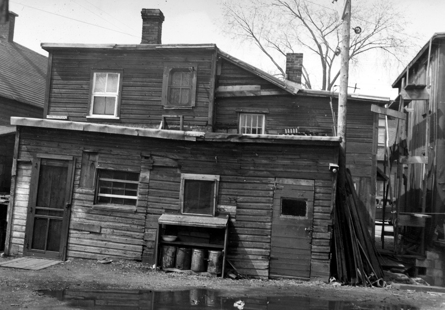 |
| The rear view of 227 & 227 1/2 Carruthers Avenue, circa 1960. (CA-24322) |
 |
| 59 Carruthers and the 61 half of the 61-63 Carruthers duplex. Photo from 1956 (CA-24784) |
These photos I found particularly neat at the archives. They are from a set of photos taken of the interior of the duplex at 61-63 Carruthers in 1956. #61 Carruthers was occupied by William and Elizabeth Guilbeault at the time (thanks to the 1956 directory which confirms that). What a great couple of shots showing the interior of a Mechanicsville residence back in the mid-1950s.
 |
| The dining room and living room of 61 Carruthers. Dec 6/63 (CA-24788) |
 |
| The kitchen of 61 Carruthers. Dec 6/63 (CA-24790) |
Here are two views of Carruthers looking north and south in the winter of 1963:
 |
| A very cool view looking south down Carruthers. Feb 15/63. Standing in front of approx #133 Carruthers, just north of Stonehurst. (CA-24805) |
 |
| Same day, same location, but looking north towards the river. (CA-24806) |
And, as always, I like to include a few articles mentioning Carruthers and some interesting events and occurrences:
 |
| Ottawa Journal, January 15, 1898. McGuire's property was lot 39 at the southeast corner of Armstrong. Now the site of 172 Armstrong Street. |
 |
| Ottawa Journal, July 30, 1903. |
 |
| Ottawa Journal, December 1, 1913. |
 |
| The first appearance of sidewalks for Carruthers Avenue. Ottawa Journal, July 5, 1916 |
 |
| Ottawa Journal, July 25, 1916 |
 |
| Ottawa Journal, September 5, 1919 |
 |
| Ottawa Journal, August 18, 1920 |
 |
| Ottawa Journal, December 16, 1922 |
 |
| Ottawa Journal, March 28, 1927 |
 |
| Ottawa Journal, January 17, 1940 |
 |
| Ottawa Journal, April 2, 1941 |
 |
| An interesting classified ad. Ottawa Journal, June 30, 1943 |
I invite readers with particular memories (or photos!) of Carruthers Avenue to share them in the comment section below! Thanks very much!
Subscribe to:
Posts (Atom)